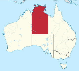
The Northern Territory is a federal Australian territory in the central and central northern regions of Australia. It is the third largest Australian federal division with an area of 1,348,094.3 square kilometres (520,502 sq mi) but the least populous with 247,327 inhabitants as at June 2018. The Northern Territory is divided administratively into 17 Local government areas (LGAs) generally known as Councils who are responsible for providing local government services.

In general, a rural area or countryside is a geographic area that is located outside towns and cities. The Health Resources and Services Administration of the U.S. Department of Health and Human Services defines the word rural as encompassing "...all population, housing, and territory not included within an urban area. Whatever is not urban is considered rural."

In law, an unincorporated area is a region of land that is not governed by a local municipal corporation; similarly an unincorporated community is a settlement that is not governed by its own local municipal corporation, but rather is administered as part of larger administrative divisions, such as a township, parish, borough, county, city, canton, state, province or country. Occasionally, municipalities dissolve or disincorporate, which may happen if they become fiscally insolvent, and services become the responsibility of a higher administration. Widespread unincorporated communities and areas are a distinguishing feature of the United States and Canada. In most other countries of the world, there are either no unincorporated areas at all, or these are very rare; typically remote, outlying, sparsely populated or uninhabited areas.
A census-designated place (CDP) is a concentration of population defined by the United States Census Bureau for statistical purposes only. CDPs have been used in each decennial census since 1980 as the counterparts of incorporated places, such as self-governing cities, towns, and villages, for the purposes of gathering and correlating statistical data. CDPs are populated areas that generally include one officially designated but currently unincorporated community, for which the CDP is named, plus surrounding inhabited countryside of varying dimensions and, occasionally, other, smaller unincorporated communities as well. CDPs include small rural communities, colonias located along the Mexico–United States border, and unincorporated resort and retirement communities and their environs.

Bragg Creek is a hamlet in southern Alberta under the jurisdiction of Rocky View County in Division No. 6. It is also recognized as a designated place by Statistics Canada.

Glenhest is a small village in County Mayo, Ireland.

Goshen is a Canadian rural community in Guysborough County, Nova Scotia.

Maskwacis, renamed in 2014 from Hobbema, is an unincorporated community in central Alberta, Canada at intersection of Highway 2A and Highway 611, approximately 70 kilometres (43 mi) south of the City of Edmonton. The community consists of two Cree First Nations communities – one on the Ermineskin 138 reserve to the north and the other on the Samson 137 reserve to the south. It also consists of an adjacent hamlet within Ponoka County. The community also serves three more nearby First Nations reserves including Samson 137A to the south, Louis Bull 138B to the northwest, and Montana 139 to the south.
Cadotte Lake is an unincorporated community in northern Alberta, Canada within Northern Sunrise County. It is located on the northern shore of the homonymous lake, along Highway 986, 79 km (49 mi) east of Peace River and 68 km (42 mi) west of the Bicentennial Highway.
Carcajou is an unincorporated community in Alberta, Canada. It is located in northern Alberta, on the banks of the Peace River, north of Manning. Carcajou is a French word meaning wolverine.
The Rural Municipality of Enniskillen No. 3 is a rural municipality (RM) in the Canadian province of Saskatchewan within Census Division No. 1 and SARM Division No. 1. Located in the southeast portion of the province, it is adjacent to the United States border, neighbouring Burke County and Renville County both in North Dakota. The RM's office is located in Oxbow.
Souris Valley No. 7 is a rural municipality in the Canadian province of Saskatchewan. It is located in southeastern Saskatchewan and is within SARM Division No. 1 and Census Division No. 2. Its population was 249 as of the 2016 Census.

The Rural Municipality of Lake Alma No. 8 is a rural municipality (RM) in the Canadian province of Saskatchewan within Census Division No. 2 and SARM Division No. 2. Located in the southeast portion of the province, it is adjacent to the United States border, neighbouring Sheridan County in Montana and Divide County in North Dakota.

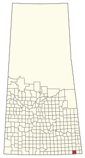
Surprise Valley No. 9 is a rural municipality in the Canadian province of Saskatchewan. It is located in southeastern Saskatchewan and is within SARM Division No. 2 and Census Division No. 2. Its population was 217 as of the 2016 Census. The southern boundary of the RM is the United States border with Sheridan County, Montana.

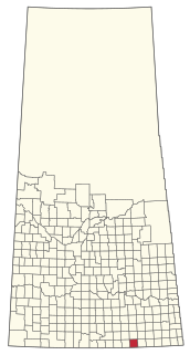
The Rural Municipality of Happy Valley No. 10 is a rural municipality (RM) in the Canadian province of Saskatchewan within Census Division No. 2 and SARM Division No. 2. Located in the southeast portion of the province, it is adjacent to the United States border, neighbouring Daniels County and Sheridan County in Montana.