
John Robert "Joe" Cocker was an English singer known for his gritty, bluesy voice and dynamic stage performances that featured expressive body movements. Most of his best known singles, such as "Feelin' Alright?" and "Unchain My Heart", were recordings of songs written by other song writers, though he composed a number of songs for most of his albums as well, often in conjunction with songwriting partner Chris Stainton.

The Stylistics are an American Philadelphia soul group that achieved their greatest chart success in the 1970s. They formed in 1968, with a lineup of singers Russell Thompkins Jr., Herb Murrell, Airrion Love, James Smith and James Dunn. All of their US hits were ballads characterized by the falsetto of Russell Thompkins Jr. and the production of Thom Bell. During the early 1970s, the group had twelve consecutive R&B top ten hits, including "Stop, Look, Listen", "You Are Everything", "Betcha by Golly, Wow", "I'm Stone in Love with You", "Break Up to Make Up" and "You Make Me Feel Brand New", which earned them 5 gold singles and 3 gold albums.

Great White is an American rock band formed in Los Angeles in 1977. The band peaked with several albums during the mid-to-late 1980s, including the platinum-selling records Once Bitten (1987) and ...Twice Shy (1989), and those albums' singles "Rock Me" and "Once Bitten, Twice Shy" received considerable airplay through radio and MTV. They charted two Top 40 hit singles on the Billboard Hot 100, with "Once Bitten, Twice Shy" and "The Angel Song." They continued to release new material into the 1990s. The band is named after both the shark with the same name, and guitarist Mark Kendall's former stage nickname.
Brute Force or brute force may refer to:
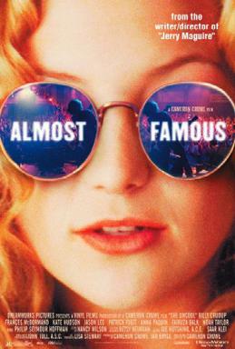
Almost Famous is a 2000 American comedy drama film written and directed by Cameron Crowe, starring Billy Crudup, Frances McDormand, Kate Hudson, Patrick Fugit, and Philip Seymour Hoffman. It tells the story of a teenage journalist, played by Fugit, writing for Rolling Stone magazine in the early 1970s, touring with the fictitious rock band Stillwater, and writing his first cover story on the band. The film is semi-autobiographical, as Crowe himself was a teenage writer for Rolling Stone.
Wendy Joan Matthews is a Canadian-born Australian singer-songwriter who has been a member of Models and Absent Friends and is a solo artist. She released Top 20 hit singles in the 1990s including "Token Angels", "Let's Kiss ", "The Day You Went Away" and "Friday's Child" with Top 20 albums, You've Always Got The Blues, Émigré, Lily, The Witness Tree and her compilation, Stepping Stones. She has won six Australian Recording Industry Association (ARIA) Awards. According to rock music historian, Ian McFarlane she provides "extraordinary, crystal-clear vocals [...] a soulfulness that was the mark of a truly gifted singer".
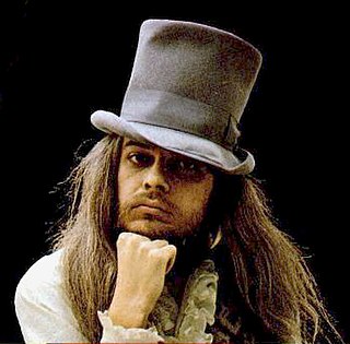
Leon Russell was an American musician and songwriter who was involved with numerous bestselling records during his 60-year career that spanned multiple genres, including rock and roll, country, gospel, bluegrass, rhythm and blues, southern rock, blues rock, folk, surf and the Tulsa sound. His recordings earned six gold records and he received two Grammy Awards from seven nominations. In 1973 Billboard named Russell the "Top Concert Attraction in the World". In 2011, he was inducted into both the Rock and Roll Hall of Fame and the Songwriters Hall of Fame.
Harlan is a given name and a surname which may refer to:
Russel is an alternate spelling of Russell.
"I'm So Lonesome I Could Cry" is a song written and recorded by American country music singer-songwriter Hank Williams in 1949. The song has been covered by a wide range of musicians.
Claudia Lennear is an American soul singer and educator. Lennear began her performing with the Superbs before becoming an Ikette in the Ike & Tina Turner Revue. She was also a background vocalist for various acts, including Joe Cocker, Leon Russell, and Freddie King. She released her only solo album in 1973. Lennear was featured in the 2013 Oscar-winning documentary 20 Feet from Stardom. She was inducted in the Rhode Island Music Hall of Fame in 2019.
Catherine Brown may refer to:

"Blue Eyes Crying in the Rain" is a song written by songwriter Fred Rose. First recorded by Elton Britt in 1946, then made more popular by Roy Acuff in 1947, the song has been covered by many artists, including Hank Williams Sr., Johnny Russell, Charley Pride, and Elvis Presley. Most notably, the song was recorded by Willie Nelson as part of his 1975 album Red Headed Stranger. Both the song and album revived Nelson's success as a singer and recording artist.

Leon Russell is the debut solo album by the singer, songwriter, and multi-instrumentalist Leon Russell. It followed his debut with the Midnight String Quartet and a production by Russell and Marc Benno billed as the Asylum Choir.
Henry Russell may refer to:
Russell, also Rosel, Rousel, Roussel, Russel or Rossell. The origin of the name has historically been subject to disagreement, with two distinct origins proposed. Early genealogists traced the Russel/Russell family of Kingston Russel from Anglo-Norman landholders bearing the toponymic surname 'de Rosel' or 'du Rozel', deriving from Rosel, Calvados, Normandy. However, J. Horace Round observed that these flawed pedigrees erroneously linked toponymic-bearing men with unrelated men who instead bore the Anglo-Norman nickname rus[s]el, given to men with red hair. This nickname was a diminutive of the Norman-French rus, meaning 'red', and was also an archaic name for the red fox, which in turn borrowed from Old Norse rossel, "red-haired", from Old Norse ros "red hair color" and the suffix -el. Round concluded "there is no reason to suppose that the surname Russell was territorial at all," and surname dictionaries have preferred to derive the surname from the nickname. Dictionaries also state that the English name Rufus originally meant "red haired".
Katherine or Catherine Russell may refer to:
This is a summary of 1971 in music in the United Kingdom, including the official charts from that year.
Anthony Russell or Russel may refer to: