Extensions
Recently, the City of Windsor's Department of Recreation has announced that there will be a widening of Riverside Drive's sidewalk into a full bike trail, connecting it to the Russell Street Neighbourhood Trail, as it would cost money to expropriate a few houses and a former nursing home (now a Dormitory for students at the University of Windsor) situated along the riverfront. The Ambassador Bridge was originally thought to be a barrier, but this has also been announced as a non-issue, since the sidewalk along Riverside Drive will simply be widened to accommodate an extension to link the two trails. No timetable for construction and completion has been set, however, but could be expected within 5–10 years.
The City of Windsor's Parks and Recreation department has rectified the gap between the Riverfront Trail and Sandwich Towne and the Russell Street Neighbourhood Trail, by extending bicycle lanes along University Avenue and Sandwich Street, all the way to Prince Road.

Windsor is a city in southwestern Ontario, Canada, on the south bank of the Detroit River directly across from Detroit, Michigan, United States. Geographically located within but administratively independent of Essex County, it is the southernmost city in Canada and marks the southwestern end of the Quebec City–Windsor Corridor. The city's population was 229,660 at the 2021 census, making it the third-most populated city in Southwestern Ontario, after London and Kitchener. The Detroit–Windsor urban area is North America's most populous trans-border conurbation, and the Ambassador Bridge border crossing is the busiest commercial crossing on the Canada–United States border.
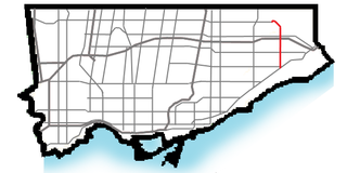
Morningside Avenue is a suburban arterial road in Toronto, Ontario, Canada. It is entirely within Scarborough, running north by north-west from the Scarborough Bluffs overlooking Lake Ontario to the eastern terminus of McNicoll Avenue near the Rouge River valley. A short extension from Steeles Avenue to Passmore Avenue has been completed but the connection to the southern section to McNicoll Avenue is still not completed.

The Windsor Sculpture Park, formerly known as the Odette Sculpture Park, is an open space in Windsor, Ontario, Canada, that shows 35 large-scale contemporary sculptures by world-renowned artists including Elisabeth Frink, Gerald Gladstone, and Sorel Etrog.
Clayton Park is a community within Halifax, Nova Scotia, Canada.
City of Parks is a municipal project to create a continuous paved pedestrian and biking trail around the city of Louisville, Kentucky while also adding a large amount of park land. The project was announced on February 22, 2005. Current plans call for making approximately 4,000 acres (1,600 ha) of the Floyds Fork floodplain in eastern Jefferson County into park space, expanding area in the Jefferson Memorial Forest, and adding riverfront land and wharfs along the Riverwalk Trail and Levee Trail. There are also plans to connect the 100-mile (160 km) Louisville trail to a planned seven mile (11 km) trail connecting the Southern Indiana cities of New Albany, Clarksville and Jeffersonville.
Windsor's Department of Parks and Recreation maintains 3,000 acres (12 km2) of green space, 180 parks, 40 miles (64 km) of trails, 22 miles (35 km) of sidewalk, 60 parking lots, vacant lands, natural areas and forest cover within the City of Windsor, as well as the Bike Trails, Bike Lanes, and Bike-Friendly Streets.
The Ganatchio Trail is the second bike trail built in Windsor, Ontario, Canada. Construction on the trail started upon the closure of Clairview Avenue. The trail extends over 5.3 km, and passes through several neighbourhoods, including Riverside and Little River, and serves Sandpoint Beach and Stop 26 Beach and Park. It was the second major trail constructed, after the Riverfront Bike Trail, with extensions east towards Tecumseh built in stages. The trail has a posted speed limit of 20 km/h. The Riverfront and the Ganatchio Trails are wide enough for two cycle lanes in each direction.
The Roy A. Battagello River Walk Bike Trail is the current backbone of the "Windsor Loop" bike trail network in Windsor, Ontario. The bike trail travels from the foot of the Ambassador Bridge, to traffic lights at Riverside Drive and Lincoln Avenue. This makes the trail the second-longest trail in the City of Windsor, at 8.0 km.
The Little River Extension is one of the newest and busiest recreational trails in Windsor, Ontario, having been built in 1996. The trail is used mainly as a link between the large subdivision of Forest Glade, to Ganatchio Trail, Sandpoint Beach, Stop 26 Beach, and Lakeview Park And Marina. The trail has a posted speed limit of 20 kilometres per hour (12 mph).
Riverside Drive is one of the main roads in Windsor, Ontario, Canada, travelling along the Detroit River, between its riverfront parks and high-rise office towers and apartment buildings. The road travels through Downtown, and towards the east end. The road is roughly 17.5 km in length, and is quite busy.
Windsor, Ontario, has a very diverse population, and this diversity is shown in its many neighbourhoods. Windsor has twenty in all, ranging from rural farmland to densely built-up areas.

Windsor, Ontario was the first Canadian city with an electric street car system, which was introduced in 1886. Other Canadian cities soon followed suit, with St. Catharines in 1887 and Toronto in 1889. By World War I, nearly 50 Canadian cities had streetcar systems in place. By the time Windsor's streetcar system was dismantled in 1937, the system's scale was extensive and it serviced all 5 of the major riverfront communities of Windsor, Ford City, Sandwich, Walkerville and Ojibway.
Clive Greenbelt Trail is an 11.3 miles (18.2 km) urban recreational trail in Clive, Iowa and forms part of the Central Iowa Trails network. This very busy recreational trail runs through Polk and Dallas Counties in Iowa. It is a curvy, paved asphalt and concrete trail.

This is a list of trails and greenways in Detroit.
The Mississippi River Trail is a designated bicycle and pedestrian trail that traverses the shores of the Mississippi River in the United States. The trail extends from the headwaters at Lake Itasca in Minnesota to near the mouth of the river in Venice, Louisiana. Much of the trail’s 3,000 miles (4,800 km) follows roadways used by motor vehicles, although some of the route is on multi-use trails. The segment in Minnesota has been designated as U.S. Bicycle Route 45, part of the U.S. Bicycle Route System.

Jones Falls Trail is a hiking and bicycling trail in Baltimore, Maryland. It mostly runs along the length of the namesake Jones Falls, a major north–south stream in and north of the city that has long acted as a major transportation corridor for the city. It also incorporates the bike path encircling Druid Hill Reservoir and its namesake park. The Jones Falls Trail forms a segment of the East Coast Greenway, a partially completed network of off-road bicycling routes that runs the length of the East Coast.
