
Inner City is part of the historic old town of Pest. Until 1949, Inner City was the 4th District. Today it is one of the two neighbourhoods of the District V of Budapest, Hungary, the other one being Lipótváros which is the political and financial centre of Hungary. Budapest's main shopping street, Váci utca is located in the District V, as is the large part of the city's commercial life, banks and travel agencies. Many tourists start sightseeing there.

Ferencváros is the 9th district of Budapest, Hungary.

Józsefváros is the 8th district of Budapest, Hungary. It is the part of the city centre in the wider sense as one of the 18-19th century older suburbs, close to Belváros.

Lipótváros is a traditional neighbourhood in the city centre of Budapest, named after King Leopold II. It is one of the two neighbourhoods of District V, the other one being Inner City (Belváros), which is the old town of Pest. Lipótváros was established in the early 19th century, and became the political and financial centre of Hungary in the early 20th century when the Parliament was built on Kossuth Square. Many ministries followed in the later decades. After the 1989 change Lipótváros gradually became again the business centre of Budapest with many banks and office buildings. The neighbourhood is rich in listed historic buildings and landmarks.

Andrássy Avenue is a boulevard in Budapest, Hungary, dating back to 1872. It links Erzsébet Square with the Városliget. Lined with spectacular Neo-renaissance mansions and townhouses featuring fine facades and interiors, it was recognised as a World Heritage Site in 2002. It is also one of Budapest's main shopping streets, with fine cafes, restaurants, theatres, Embassies and luxury boutiques. Among the most noticeable buildings are the State Opera House, the former Ballet School, the Zoltán Kodály Memorial Museum and Archives, the Hungarian University of Fine Arts and the Ferenc Hopp Museum of East Asian Arts.
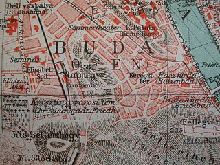
Tabán usually refers to an area within the 1st district of Budapest, the capital of Hungary. It lies on the Buda side of the Danube, to the south of György Dózsa Square, on the northern side of Elisabeth Bridge and to the east of Naphegy. Outside of Budapest, several other Hungarian cities and towns also have districts called Tabán.

Hősök tere is one of the major squares in Budapest, Hungary, noted for its iconic statue complex featuring the Seven chieftains of the Magyars and other important Hungarian national leaders, as well as the Memorial Stone of Heroes, often erroneously referred as the Tomb of the Unknown Soldier. The square lies at the outbound end of Andrássy Avenue next to City Park (Városliget). It hosts the Museum of Fine Arts and the Műcsarnok. The square has played an important part in contemporary Hungarian history and has been a host to many political events, such as the reburial of Imre Nagy in 1989. The sculptures were made by sculptor Zala György from Lendava.

Sashegy is a hill and neighbourhood in Budapest, Hungary. It is a green, upper middle class area in Buda with expensive family homes. Administratively Sashegy is divided between the 11th and the 12th districts of Budapest.
Budapest is the capital of Hungary. Below is a list of public place names of Budapest that refer to famous people, cities or historic events. Generality of Budapest's public place names relate to the Hungarian national history. In Budapest there are about 8,600 named public place.

The Danube Promenade is located on the Pest side of Budapest, Hungary. On the bank of the Danube, this promenade extends from the Széchenyi Chain Bridge to the Erzsébet Bridge.

Bauhaus was a dominant architectural tendency in Budapest, the capital of Hungary, between 1930 and 1948. Large residential buildings, cinemas, churches and even an airport was built in this style, in particular in Újlipótváros in the XIII district, and Városmajor and Pasarét in the II district of the city.

Balatonföldvár is a popular resort town in Somogy, Hungary, on the southern side of Lake Balaton, approximately 120 km southwest from Budapest and about 23 km southwest from Siófok, the "capital of Balaton". Balatonföldvár is a frequently visited tourist destination among Hungarians and foreign guests because of its natural beauties, historical heritages or its countless leisure opportunities. The town offer several water sport and mainland sport activities.

Ecser is a village in Pest county, Budapest metropolitan area, Hungary.
Gábor Preisich was a Hungarian architect. He won the Herder Prize in 1975 along with Romanian poet Nichita Stănescu.
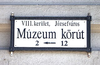
Budapest's Palotanegyed forms a central district of Pest, the eastern half of Budapest. It consists of the inner part of the city's Eighth District, or Józsefváros, which was named in 1777 after the heir to the Austrian throne, Joseph, the later Emperor Joseph II. Józsefváros was earlier called the Alsó-Külváros. The Palotanegyed's borders are the Múzeum körút to the west, Rákóczi út to the north, the József körút to the east and Üllői út to the south.

Epreskert Art Colony was an artists' colony in Budapest in the last decades of the 19th and the first half of the 20th century. Among the artists who worked and lived there the most important were sculptors György Zala and Adolf Huszár, and painter Árpád Feszty.


