
Scott County is a county located in the U.S. state of Tennessee. As of the 2010 census, the population was 22,228. Its county seat is Huntsville. Scott County is known for having seceded from Tennessee in protest of the state's decision to join the Confederacy during the Civil War, and subsequently forming The Free and Independent State of Scott.

Entre Ríos is a central province of Argentina, located in the Mesopotamia region. It borders the provinces of Buenos Aires (south), Corrientes (north) and Santa Fe (west), and Uruguay in the east.

Jujuy is a province of Argentina, located in the extreme northwest of the country, at the borders with Chile and Bolivia. The only neighboring Argentine province is Salta to the east and south.

Trelew is a city in the Chubut Province of Argentina. Located in Patagonia, the city is the largest and most populous in the low valley of the Chubut River, with 97,915 inhabitants as of 2010. The Trelew municipality is part of the Rawson Department, whose capital, Rawson, is also the provincial capital.
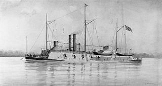
USS Benton (1861) was an ironclad river gunboat in the United States Navy during the American Civil War. She was named for American senator Thomas Hart Benton. Benton was a former center-wheel catamaran snagboat and was converted by James B. Eads, St. Louis, Missouri, in 1861 and commissioned February 24, 1862 as part of the Army's Western Gunboat Flotilla.
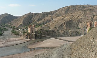
Cornelio Saavedra is a province in the north-eastern parts of the Bolivian Potosí Department. The capital of the province is Betanzos with 4,168 inhabitants in the year 2001.
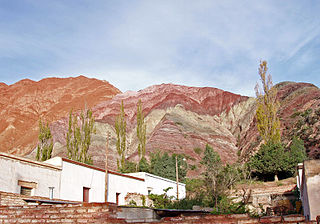
The Quebrada de Humahuaca is a narrow mountain valley located in the province of Jujuy in northwest Argentina, 1,649 km (1,025 mi) north of Buenos Aires. It is about 155 km (96 mi) long, oriented north-south, bordered by the Altiplano in the west and north, by the Sub-Andean hills in the east, and by the warm valleys in the south.

Mizque is a town in the Cochabamba Department, Bolivia. It is the capital of the Mizque Province. Mizque is located in the valley of the Mizque River, one of the main tributaries of the Río Grande.
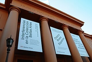
The Museo Nacional de Bellas Artes is an Argentine art museum in Buenos Aires, located in the Recoleta section of the city. The Museum inaugurated a branch in Neuquén in 2004.

Kyburz is a small unincorporated community in El Dorado County, California. It is located along the South Fork of the American River and U.S. Route 50, and is surrounded by the Eldorado National Forest. Its elevation is 4058 feet above sea level.
Inchupalla District is one of eight districts of the province Huancané in Peru.
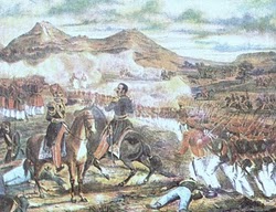
The Battle of Famaillá, was a Federal Party victory, under the command of former Uruguayan president Manuel Oribe, over the army of the Unitarian Party under general Juan Lavalle, during the Argentine Civil War.
The Department of Virginia and North Carolina was a United States Military department encompassing Union-occupied territory in the Confederate States during the Civil War. In 1863 it was formed by the merging of two previously existing departments: the Department of Virginia and the Department of North Carolina. In 1865 the two departments were once again separated.
White Oak Creek Marina is a marina and campground located at the mouth of White Oak Creek and the Ohio River near Higginsport, Ohio.
Colonia Nueva Coneta is a village and municipality in Catamarca Province in northwestern Argentina.
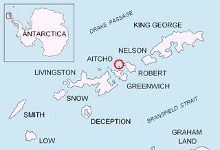
Table Island is a conspicuous flat-topped, rocky island lying north of Greenwich Island and north-northwest of the Aitcho group on the west side of English Strait in the South Shetland Islands, Antarctica. The island is rising to over 150 metres and extending 1.4 by 1 kilometre, with a surface area of 112 hectares. It is separated from Aitcho Islands to the south-southeast by the 1.9-kilometre (1.2-mile) wide Klimash Passage.

The flag of Macha is the name given to a pair of flags of Argentina found at a chapel in the hamlet of Titiri, near the village of Macha, north of Potosí, Bolivia. They are considered to be the first physical flags created by Manuel Belgrano, who in November 1813 hid the standards to prevent them from falling into enemy hands. They were discovered in 1885. Bolivia kept one of those flags at Sucre; the other was given to Argentina in 1896 and is currently kept at the National Historical Museum. Tucumán Province has used it as provincial flag since 2010. The flag preserved in Argentina is a triband of blue, white and blue bands, like the modern flag of Argentina, but the one kept in Bolivia is a triband of white, blue and white.
The department of Tafí Viejo is a department of the province of Tucumán (Argentina), created in 1907 by the reform of the provincial constitution, which divided the old department Tafí. Its head is the homonymous city. Bordered on the north by the department Trancas, east to Burruyacú and Cruz Alta, south of Capital, Yerba Buena and Lules, and west to Tafí del Valle.

The Skipton Academy is a coeducational secondary school located in Skipton, North Yorkshire, England.
