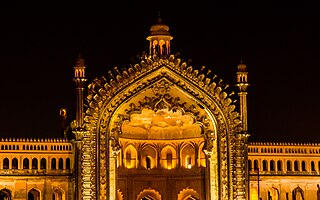
Lucknow is the capital and the largest city of the Indian state of Uttar Pradesh and it is the administrative headquarters of the eponymous district and division. Having a population of 2.8 million as per 2011 census, it is the eleventh most populous city and the twelfth-most populous urban agglomeration of India. Lucknow has always been a multicultural city that flourished as a North Indian cultural and artistic hub, and the seat of power of Nawabs in the 18th and 19th centuries. It continues to be an important centre of governance, administration, education, commerce, aerospace, finance, pharmaceuticals, information technology, design, culture, tourism, music, and poetry. Lucknow, along with Agra and Varanasi, is in the Uttar Pradesh Heritage Arc, a chain of survey triangulations created by the Government of Uttar Pradesh to boost tourism in the state.

Meerut is a city in the western region of the Indian state of Uttar Pradesh. Located in the Meerut district, the city is 80 km (80,000 m) northeast of the national capital New Delhi, and is 480 km (300 mi) west of the state capital, Lucknow. Meerut is the second-most populous city in the National Capital Region (NCR), a region centered on Delhi. As of 2011, Meerut is the 33rd most populous urban agglomeration and the 26th most populous city in India.

Aligarh is a city in the state of Uttar Pradesh in India. It is the administrative headquarters of Aligarh district, and lies 342 kilometres (213 mi) northwest of state capital Lucknow and approximately 130 kilometres (81 mi) southeast of the capital, New Delhi. The cities and districts which adjoin Aligarh are: Gautam Buddha Nagar, Bulandshahr, Sambhal, Badaun, Kasganj, Hathras, Etah and Mathura, as well as Palwal district of Haryana. As of 2011, Aligarh is the 53rd most populous city in India.

Firozabad district is one of the western districts of the Indian state of Uttar Pradesh, which has Firozabad city as its district headquarters. Administratively, the district is a part of the Agra division.

Raiganj is a city and a municipality in the Indian state of West Bengal. It is the headquarters of the Uttar Dinajpur district. The police station was set up 125 years ago and railway connectivity reached the place 115 years ago. The city houses the 111-year-old Raiganj Coronation High School and more than 50-years-old government primary Raiganj Sarala Sundari GSFP School. Raiganj got its railway connection in 1896. The train used to go to Parbatipur junction in Bangladesh from Raiganj. It is a 200-year-old town.

Ancholi is a neighbourhood in the Karachi Central district of Karachi, Pakistan.

Model Colony Karachi is a neighborhood in Karachi, Pakistan, that is within Korangi District. It is situated on the outskirts of the city about two miles northeast of Jinnah International Airport, Karachi's international airport. Other important buildings in the vicinity are the Security Press, which is Pakistan's mint, and the SOS Village, which houses about 200 orphans.
Gola Gokarannath or Gola is the city, municipal board, thana and tehsil in Lakhimpur Kheri district in the Indian state of Uttar Pradesh. Gola Gokarnnath is a Hindu pilgrimage site, famous for its Gokarnnath temple. The description of this pilgrimage is also found in Hindu scriptures, lakhs of devotees come here during Sawan and Mahashivratri to have darshan of Lord Shiva.
The Kakori Shaikh are a Muslim community found in the state of Uttar Pradesh in India. They are also found in the province of Sindh in Pakistan, particularly the city of Karachi.
Uttar Pradesh is the most populous state in India with a population of nearly 240 million people. The economy of Uttar Pradesh is the fifth largest among states in India. The gross state domestic product (GSDP) of Uttar Pradesh increased from Rs 22.58 lakh crore in 2022–2023 to Rs 25.48 lakh crore in 2023–2024. Merchandise exports from Uttar Pradesh reached US$21.03 billion in FY22.

The Naqvis are people found predominantly in Iran, Iraq, and the South Asian countries. They claim descent from the Imam.
Milkipur is a town and tehsil in Ayodhya district in the Indian state of Uttar Pradesh. Milkipur is 32 km south of district headquarters Ayodhya city. District Ayodhya consists of 11 blocks and Milkipur is a block in Ayodhya, Uttar Pradesh.

The Sadaat Amroha or Amrohi Sayyid or Sayyid of Amroha are a community of Sayyids, historically settled in the town of Amroha, in the Indian state of Uttar Pradesh. Many members of the community migrated to Pakistan after independence and settled in Karachi, Sindh, Bewal - Rawalpindi - through Syed Dewan Shah Abdul Baqi Guzri Bewali bin Syed Abdul Wahid Guzri (Amroha) some descendants of whom settled in Azad Kashmir, from which some now also reside in the United Kingdom.
Dastagir Society is also called Dastagir Colony by some. It is a residential area in Gulberg Town, in Karachi, Sindh, Pakistan.

Nasirabad is a Nagar panchayat and a Gram Sabha in Chhatoh Block, Raebareli district in the state of Uttar Pradesh, India. It was declared a Nagar Panchayat in 2017. Located southeast of Jais on the road to Salon, Nasirabad is an old town partly built on an elevated area that covers the ruins of an ancient fort. It is one of the main Muslim centres in the district. Muslims make up about half the town's population, and the Shia and Sunni communities are both prominent. As of 2011, Nasirabad's population is 13,648, in 2,243 households. It is located 37 km from Raebareli the district headquarters. It is the headquarters of a nyaya panchayat that also includes 6 other villages.
Sadat is a name given to descendants of the Islamic prophet, Muhammad.
Daranagar is a town in Kaushambi, a suburb of Allahabad, in Uttar Pradesh, India. The town is located approximately 17 km to the north of the district headquarters of Manjhanpur and is known for the main Pilgrim Center and it is situated at the bank of the Ganga river. The main attraction in the town is the Daranagar Tirtha, dedicated to Bhagwan Shri Rishabhdev. In addition to these well-known monuments, there are many other temples, such as the Hanuman Temple, Jain Temple, Jwala Devi Temple, Ram Janaki Temple, and Kalbhairav Temple. Daranagar is known for the Shia Jama Masjid Syedwarah and the Sunni Shahi Jama Masjid built by Dara Shikoh, the son of the famous Mughal emperor Shah Jahan.

Saifai is a large village and university town in the Etawah district of the Indian state of Uttar Pradesh. It is also a sub-division (Tehsil) and Block of the Etawah district. It is the birthplace of Mulayam Singh Yadav, the founding president of the Samajwadi Party, former Minister of Defence in India, and former Chief Minister of Uttar Pradesh.

Padera, also spelled Pandera, is a village in Harchandpur block of Raebareli district, Uttar Pradesh, India. As of 2011, its population is 3,034, in 564 households. It has one primary school and no healthcare facilities.

Shia College is a college located in old Lucknow, Uttar Pradesh, India. It is affiliated with the University of Lucknow and one of the institutes of higher education in India.