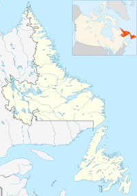
Saint Pierre and Miquelon, is a self-governing territorial overseas collectivity of France in the northwestern Atlantic Ocean, located near the Canadian province of Newfoundland and Labrador. An archipelago of eight islands, St. Pierre and Miquelon is a vestige of the once-vast territory of New France. Its residents are French citizens. The collectivity elects its own deputy to the National Assembly and participates in senatorial and presidential elections. It covers 242 km2 (93 sq mi) of land and had a population of 5,819 as of the January 2022 census.

The Gulf of St. Lawrence fringes the shores of the provinces of Quebec, New Brunswick, Nova Scotia, Prince Edward Island, Newfoundland and Labrador, in Canada, plus the islands Saint-Pierre and Miquelon, possessions of France, in North America.

The Arctic Archipelago, also known as the Canadian Arctic Archipelago, is an archipelago lying to the north of the Canadian continental mainland, excluding Greenland and Iceland

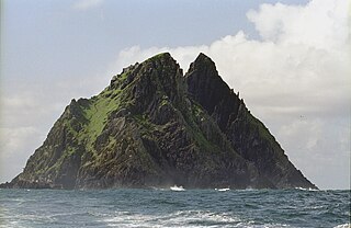
Skellig Michael, also called Great Skellig, is a twin-pinnacled crag 11.6 kilometres (7.2 mi) west of the Iveragh Peninsula in County Kerry, Ireland. The island is named after the archangel Michael, with "Skellig" derived from the Irish language word sceilig, meaning a splinter of stone. Its twin island, Little Skellig, is smaller and inaccessible. The two islands rose c. 374–360 million years ago during a period of mountain formation, along with the MacGillycuddy's Reeks mountain range. Later, they were separated from the mainland by rising water levels.

In geography, a pole of inaccessibility is the farthest location in a given landmass, sea, or other topographical feature, starting from a given boundary, relative to a given criterion. A geographical criterion of inaccessibility marks a location that is the most challenging to reach according to that criterion. Often it refers to the most distant point from the coastline, implying the farthest point into a landmass from the shore, or the farthest point into a body of water from the shore. In these cases, a pole of inaccessibility is the center of a maximally large circle that can be drawn within an area of interest only touching but not crossing a coastline. Where a coast is imprecisely defined, the pole will be similarly imprecise.
This is a list of the extreme points of the United Kingdom: the points that are farther north, south, east or west than any other location. Traditionally the extent of the island of Great Britain has stretched "from Land's End to John o' Groats".

Route 200, known locally as Saddle Road, traverses the width of the Island of Hawaiʻi, from downtown Hilo to its junction with Hawaii Route 190 near Waimea. The road was once considered one of the most dangerous paved roads in the state, with many one-lane bridges and areas of marginally maintained pavement. Most of the road has now been repaved, and major parts have new re-alignments to modern standards. The highway is mostly one-lane in each direction, but there are two lanes on the uphill portions. The highway reaches a maximum elevation of 6,632 feet (2,021 m) and is subject to fog and low visibility. Many rental car companies used to prohibit use of their cars on Saddle Road, but now allow use of the road. The highway experiences heavy use as it provides the shortest driving route from Hilo to Kailua-Kona and access to the slopes of Mauna Loa and the Mauna Kea Observatories.
Red Bay is a fishing village in Labrador, notable as a significant underwater archaeological site in the Americas. Between 1530 and the early 17th century, it was a major Basque whaling area. Several whaling ships, both large galleons and small chalupas, sank there, and their discovery led to the designation of Red Bay in 2013 as a UNESCO World Heritage Site.
Cassidy is an unincorporated community straddling Haslam Creek. near the east coast of southern Vancouver Island, British Columbia, Canada. The location on BC Highway 19 is about 98 kilometres (61 mi) by road north-west of Victoria, and 14 kilometres (9 mi) south of Nanaimo.

Rimouski-Neigette—Témiscouata—Les Basques is a federal electoral district in Quebec, Canada, that has been represented in the House of Commons of Canada since 2004.
Arqiva is a British telecommunications company which provides infrastructure, broadcast transmission and smart meter facilities in the United Kingdom. The company is headquartered at the former Independent Broadcasting Authority headquarters in Crawley, Hampshire, England. Its main customers are broadcasters and utility companies, and its main asset is a network of circa. 1,500 radio and television transmission sites. It is owned by a consortium of investors led by Digital 9 Infrastructure and the Australian investment house Macquarie Bank. Arqiva is a patron of the Radio Academy.

UTC−03:00 is an identifier for a time offset from UTC of −03:00.

Uharte-Arakil is a town and municipality located in the province and autonomous community of Navarre, northern Spain.

Blanc-Sablon is a municipality located on the shore of Blanc-Sablon Bay, in the Strait of Belle-Isle, Le Golfe-du-Saint-Laurent RCM, Côte-Nord, Quebec, Canada.

Gaztelugatxe is an islet on the coast of the Bay of Biscay belonging to the biscayan municipality of Bermeo, in the Basque Autonomous Community. It is connected to the mainland by a man-made bridge. On top of the island stands a hermitage named Gaztelugatxeko Doniene in Basque, dedicated to John the Baptist, that late discoveries indicate might date back to the 9th century. With another small neighboring island, Aketx, they form a protected biotope that extends from the town of Bakio to Cape Matxitxako, on the Bay of Biscay.
Plum Point is a local service district and designated place in the Canadian province of Newfoundland and Labrador. It is west of Anchor Point.

Mauna Kea State Recreation Area also known as Mauna Kea State Park, is a state of Hawaii protected area at the southern base of Mauna Kea.

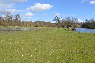
Temple Island Meadows is a 14.1-hectare (35-acre) biological Site of Special Scientific Interest on the Buckinghamshire bank of the River Thames. It is north of Henley-on-Thames and opposite Temple Island, an island in the Thames.

Cigarette Island Park is a 5-acre (2.0 ha) public park in East Molesey, in the Borough of Elmbridge, Surrey, close to the border with Greater London and Hampton Court Palace.


