The beach at Saint Lawrence GapSt. Lawrence Church.A small cove in St. Lawrence Gap with fishing boats.
Saint Lawrence Gap, Christ Church is a neighbourhood in Barbados. Often known as "the Gap", Saint Lawrence Gap is located on the southern coast of Barbados along the island's Highway 7. Found between Oistins to the east and Worthing to the west, it features a 1.5-kilometer stretch of bars, hotels, dance clubs, restaurants, inns, resorts, and shops along a white powdery-sand beachfront. It is situated roughly 5 km southeast of the capital city Bridgetown.
The area has been upgraded in recent years[when?] as part of the government's Urban Renewal and Development programme. Upgrades included a new boardwalk, street lighting, road paving and re-development of the Dover Beach area (new beach facilities and food and shopping kiosks).[citation needed]
The neighbourhood has one small church: St. Lawrence by the Sea. There are larger hotels at the eastern end of the neighbourhood, including a Sandals resort and other large hotels such as the Divi Southwinds and Turtle Beach, while the bars and restaurants are to a heavier concentration to the area's western end. There is a small minimarket in the centre of St. Lawrence Gap and one to its eastern end. Scotiabank have a branch in the centre of the resort. To the eastern end of Saint Lawrence Gap, there is a playing field.
Bridgetown is the capital and largest city of Barbados. Formerly The Town of Saint Michael, the Greater Bridgetown area is located within the parish of Saint Michael. Bridgetown is sometimes locally referred to as "The City", but the most common reference is simply "Town". As of 2014, its metropolitan population stands at roughly 110,000.
Canada has a large domestic and foreign tourism industry. The second largest country in the world, Canada's wide geographical variety is a significant tourist attractor. Much of the country's tourism is centred in the following regions: Toronto, Montreal, Quebec City, Vancouver/Whistler, Niagara Falls, Vancouver Island, Canadian Rockies, British Columbia's Okanagan Valley, Churchill, Manitoba and the National Capital Region of Ottawa-Gatineau. The large cities are known for their culture, diversity, as well as the many national parks and historic sites.
Little Italy, sometimes referred to as College Street West, is a district in Toronto, Ontario, Canada. It is known for its Italian Canadian restaurants and businesses. There is also a significant Latin-Canadian and Portuguese-Canadian community in the area. The district is centred on a restaurant/bar/shopping strip along College Street, imprecisely between Harbord Street and Dundas Street, and spreading out east and west between Bathurst Street and Ossington Avenue. It is contained within the larger city-recognized neighbourhood of Palmerston-Little Italy.
Queen Street is a major east–west thoroughfare in Toronto, Ontario, Canada. It extends from Roncesvalles Avenue and King Street in the west to Victoria Park Avenue in the east. Queen Street was the cartographic baseline for the original east–west avenues of Toronto's and York County's grid pattern of major roads. The western section of Queen is a centre for Canadian broadcasting, music, fashion, performance, and the visual arts. Over the past twenty-five years, Queen West has become an international arts centre and a tourist attraction in Toronto.
Sveti Vlas, is a town and resort on the Black Sea coast in Nesebar municipality, Burgas Province, Bulgaria. In July, 2007 its population was 3,869.
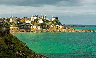
Dinard is a commune in the Ille-et-Vilaine department, Brittany, northwestern France.
The parish of Christ Church is one of eleven historic political divisions of Barbados. It has a land area of 57 km2 (22 sq mi) and is found at the southern end of the island. Christ Church has survived by name as one of the original six parishes created in 1629 by Governor Sir William Tufton.
The parish of Saint James is an area located in the western central part of the country of Barbados. Increasingly St. James is becoming known as the playground of the rich and famous, and as a haven for sun-starved tourists with its up-market hotel resorts.
Litochoro is a town and a former municipality in the southern part of the Pieria regional unit, Macedonia, Greece. Since the 2011 local government reform it has been part of the Dio-Olympos municipality, of which it is the seat and a municipal unit. It is located at the base of Mount Olympus, on the western shore of the Thermaic Gulf. The first recorded mention of Litochoro is in an account of a visit by Saint Dionysius to Mount Olympus in the 16th century. The town is a popular destination for those wishing to climb Mount Olympus as almost all climbing routes begin to the southwest of the town. One of the most famous Litohorians was Christos Kakkalos, who made the first modern unaided ascent of Mount Olympus in 1913.
Sainte-Catherine Street is the primary commercial artery of Downtown Montreal, Quebec, Canada. It crosses the central business district from west to east, beginning at the corner of Claremont Avenue and de Maisonneuve Boulevard in Westmount, and ending at the Grace Dart Extended Care Centre by Assomption metro station, where it folds back into Notre-Dame Street. It also traverses Ville-Marie, passing just east of Viau in Mercier–Hochelaga-Maisonneuve. The street is 11.2 km long, and considered the backbone of Downtown Montreal.
Sandals Resorts is a Jamaican operator of all-inclusive couples resorts in the Caribbean. The company is a part of Sandals Resorts International (SRI), which also operates Beaches Resorts, Fowl Cay Resort, and several private villas. Founded by Jamaican-born entrepreneur Gordon "Butch" Stewart in 1981, SRI is based in Montego Bay, Jamaica and is responsible for development, service standards, training, and day-to-day operations of the resorts.
Le Plateau-Mont-Royal is a borough (arrondissement) of the city of Montreal, Quebec, Canada.
A resort town, resort city or resort destination is an urban area where tourism or vacationing is the primary component of the local culture and economy. A typical resort town has one or more actual resorts in the surrounding area. Sometimes the term resort town is used simply for a locale popular among tourists. One task force in British Columbia used the definition of an incorporated or unincorporated contiguous area where the ratio of transient rooms, measured in bed units, is greater than 60% of the permanent population.
Oistins Bay is located southeast of Carlisle Bay, close to the southernmost point of Barbados, South Point. It's the largest town in the Christ Church Parish, and has been the center of a vibrant fishing community for hundreds of years. In the market place there, you can still buy a variety of cleaned or cooked Seafood year round. There's a regular fish fry going on Fridays and Saturdays, along with a great many pop-up shops with artists and crafts offered. Its also a place to get a 'Bajean' (Barbadian) treat, the islands take-a-way or fast food: Flying Fish sandwich. That's something available during the weekly fish fry for the young folks, but available Island wide. But if your preference is more upscale, there are several restaurants throughout the Oistins Bay, and St Lawrence Gap area's. This area is the place for night life, much of the festive and vibrant clubs and dance halls range from Oistins Bay to Sandy Bay, just north of Bridgetown.
The Sheraton Mall is a shopping and entertainment complex located close to the fringe of both Sargeants' Village and Vauxhall in the Parish of Christ Church, Barbados. The mall boasts having roughly 120 stores and services along with the only multiplex cinema on the island. The major anchor stores for the mall are Courts, DaCosta Mannings, and the Olympus Theatres cinema multiplex.
Downtown Toronto is the main city centre of Toronto, Ontario, Canada. Located entirely within the district of Old Toronto, it is approximately 16.6 square kilometres in area, bounded by Bloor Street to the northeast and Dupont Street to the northwest, Lake Ontario to the south, the Don Valley to the east, and Bathurst Street to the west. It is also the home of the municipal government of Toronto and the Government of Ontario.
The Wildey area of the Parish of Saint Michael located roughly 4 km east of Bridgetown, it lies on the border with the Parish of Christ Church. Normally a very busy area with the ABC Highway, Wildey is one of the main convergence points for vehicles travelling either towards the capital-city Bridgetown or towards points in northern Barbados. In recent years the area was reconfigured for traffic mitigation, the tri-directional split or fork in the highway formerly known as the "Wildey Y" was changed to only allow southbound traffic to turn left or right on to Wildey Road only. Northbound traffic must now travel on Wildey Road to Highway R road which brings traffic back to BET hill.
St Mary's Bay, also known as The Bay, is a coastal village in Kent, England. Situated on Romney Marsh, St Mary's Bay has a long sandy beach which stretches north to Dymchurch and south to Littlestone-on-Sea. It has a station on the Romney, Hythe and Dymchurch Railway.
Clearwater Beach includes a resort area and a residential area on a barrier island in the Gulf of Mexico in Pinellas County on the west-central coast of Florida, United States. Located just west over the Intracoastal Waterway by way of the Clearwater Memorial Causeway from the rest of the city of Clearwater, Florida, of which it is part, Clearwater Beach is at a geographic latitude of 27.57 N and longitude 82.48 W.
Praia da Oura is a blue flag beach within the Municipality of Albufeira, in the Algarve, Portugal. The beach is in the eastern district of Albufeira in the neighbourhood called Areias de São João. Its flanked by Praia dos Aveiros to the west and Praia de Santa Eulália to the eastern side. The beach is approximately 900 metres (3,000 ft) in length and is 450 metres (1,480 ft) wide at low tide.
This page is based on this Wikipedia article Text is available under the CC BY-SA 4.0 license; additional terms may apply. Images, videos and audio are available under their respective licenses.