
Belize is a country on the north-eastern coast of Central America. It is bordered by Mexico to the north, the Caribbean Sea to the east, and Guatemala to the west and south. It also shares a maritime boundary with Honduras to the southeast. Belize is a member of the Caribbean Community (CARICOM), and is considered part of the Caribbean region and the historical British West Indies.

Punta Gorda, declared a town on Monday, 21 January 1895, known locally as P.G., is the capital and largest town of Toledo District in southern Belize. Punta Gorda is the southernmost sizable town in the nation, with a population of about 5,000 people. Although the town bears a Spanish name, its inhabitants are mostly Kriol/English-speaking and are primarily of Garifuna, East Indian, Kriol, and Maya descent.

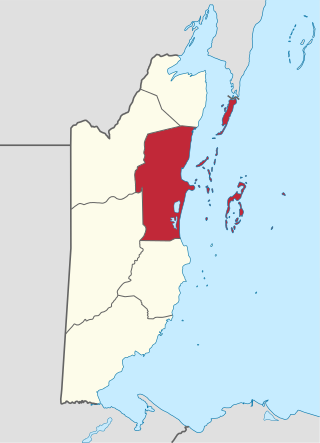
Stann Creek District is a district in the south east region of Belize. According to the 2022 census, the district had a population of 48,162 people. Its capital is the town of Dangriga, formerly known as "Stann Creek Town." Stann comes from "stanns," or safe havens used by colonialists coming from the "old world" to the "new world."

Toledo District is the southernmost and least populated district in Belize. Punta Gorda is the District capital. According to the Human Development Index (HDI), it is the second most developed region in the country. The district has a diverse topography which features rainforests, extensive cave networks, coastal lowland plains, and offshore cays. Toledo is home to a wide range of cultures such as Mopan, Kekchi Maya, Creole, Garifuna, East Indians, Mennonites, Mestizos, and descendants of US Confederate settlers.
Belize District is a district of the nation of Belize. Its capital is Belize City.

Corozal District is the northernmost district of the nation of Belize. The population was 46,071 in 2024. The district capital is Corozal Town.

Cayo District is located in the west part of Belize, and it contains the capital, Belmopan. It is the most extensive, second-most populous and third-most densely populated of the six districts of Belize. The district's capital is the town of San Ignacio.
Guinea Grass is a village in the Orange Walk District of the nation of Belize. It is 38 metres above sea level. According to the 2000 census, Guinea Grass had a population of 2,510 people; by 2010 the census figures showed a population of 3,500. The population is made up of mostly Mestizos, Creoles, and East Indians. There are a number of Mennonites, Taiwanese and other Central American immigrants living near or immediately in the village.
Chunox is a village located in the Corozal District of Belize, with a population of 1,143 people. It is primarily an agricultural community surrounded by sugar cane fields, and is located on the east bank of Laguna Seca. The official language is English, but most residents speak Spanish due to their Maya Mestizo ancestry. St. Viator Vocational High School serves the village. There are several Maya residential mound groups in Chunox from the Classic Period. Copper Bank, a fishing village, is situated across the lagoon from Chunox.
Mullins River is the name of both a river and of a village on that river in the Stann Creek District of Belize.

Gales Point Manatee is a village in Belize District in the nation of Belize, Central America. The village is bordered by five other communities, namely Mullins River, St. Margaret, La Democracia, Gracie Rock, and Freetown Sibun. The village is bordered east by the Caribbean Sea. In 2000, Gales Point had a population of about 500 people, most of whom subsist on fishing and farming.
Belizean Creoles, also known as Kriols, are a Creole ethnic group native to Belize.

Copper Bank is a fishing village in the Corozal District of Belize. It is situated on the west bank of Laguna Seca, a shallow lagoon that empties into Chetumal Bay just north-east of the village. The closest settlement is Chunox, located approximately 1.25 miles away on the east bank of the Laguna Seca.
Gardenia is a village in Belize District, Belize located about 20 miles (32 km) north of Belize City.

Tourism in Belize is a major industry in the country. The sector has grown in the 2020s, with international arrivals reportedly increasing 30% in 2024, the highest rate in the Caribbean. Former Prime Minister Dean Barrow stated his intention to use tourism to combat poverty throughout the country.
Rancho Dolores is a village in Belize District, Belize, about 45 miles from Belize City. Part of the interest of Rancho Dolores is the way Creole life has been preserved, in contrast to the other villages, where is it largely moribund. Cooking is still done on the traditional firehearth, using the kiskis, a type of tongs made from the cohune palm. Every May, there are dances for Holy Week, including the hogshead dance and the plantation dance.
Burrell Boom is on the Belize River twenty miles above Belize City, Belize. Tourists pass through this historic village on their way to the Community Baboon Sanctuary, where the population of black howler monkeys has grown to over 2,000.
Isabella Bank is a village in Belize District in Belize, Central America. It is located on the banks of the Belize River approximately two miles from the village of Bermudian Landing. It can be reached by traveling the Philip Goldson Highway out of Belize City to the junction of the road that branches into Burrell Boom. There is a paved road from Burrell Boom to Isabella Bank. Isabella Bank is well known for having a very respected private primary school- Isabella Harmony Private School. This prestigious village has a small but well respected population of 130 individuals. The central and outlying a bunnger age are located in pine ridge type terrain with very light, sandy, soil. Closer to the river the soil becomes a heavier clay, which supports thicker vegetation. Traditionally a farming community using slash and burn methods, there has been largely a transition to a workforce that commutes to larger metropolitan areas as day laborers. This has been particularly evident in the younger portion of the populace. As of 2016, the village was connected to the pipe water system operated by Belize Water Services. (BWS) Residents also benefit from grid electric service provided by Belize Electricity Limited (BEL). A number of residents have cleared acreage where they raise livestock including cattle and sheep. There is currently no store or shop operating in the village, but supplies are readily available at shops in nearby Bermudian Landing and Scotland Halfmoon. Public transportation includes a number of local bus lines serving surrounding villages and connecting with Belize City.

Bullet Tree Falls is a village located along the Mopan River in Cayo District, Belize. It lies approximately five kilometers northwest of San Ignacio. According to the 2010 census, Bullet Tree Falls has a population of 2,124 people in 426 households. The population consists mainly of Spanish-speaking mestizos, along with a smaller number of Maya and Creoles. The village is governed by a seven-person village council.

Community Baboon Sanctuary is a protected area in Belize. It was established in 1985 to help address the threats of agriculture, logging and hunting of the black howler monkey ('baboon') and to educate locals and visitors about the importance of biodiversity, sustainability, and to promote the economic development of the Bermudian Landing community.