| Salinas River (Guam) | |
|---|---|
 | |
| Location | |
| Country | Guam |
| Physical characteristics | |
| Mouth | |
• coordinates | 13°23′07″N144°39′12″E / 13.3852778°N 144.6533333°E |
The Salinas River is a river in the United States territory of Guam. [1]
| Salinas River (Guam) | |
|---|---|
| | |
| Location | |
| Country | Guam |
| Physical characteristics | |
| Mouth | |
• coordinates | 13°23′07″N144°39′12″E / 13.3852778°N 144.6533333°E |
The Salinas River is a river in the United States territory of Guam. [1]

Guam is an organized, unincorporated territory of the United States in the Micronesia subregion of the western Pacific Ocean. Guam's capital is Hagåtña, and the most populous village is Dededo. It is the westernmost point and territory of the United States, reckoned from the geographic center of the U.S. In Oceania, Guam is the largest and southernmost of the Mariana Islands and the largest island in Micronesia.
Salinas is a city in the U.S. state of California and the county seat of Monterey County. With a population of 163,542 in the 2020 Census, Salinas is the most populous city in Monterey County. Salinas is an urban area located along the eastern limits of the Monterey Bay Area, lying just south of the San Francisco Bay Area and 10 miles (16 km) southeast of the mouth of the Salinas River. The city is located at the mouth of the Salinas Valley, about eight miles (13 km) from the Pacific Ocean, and it has a climate more influenced by the ocean than the interior.
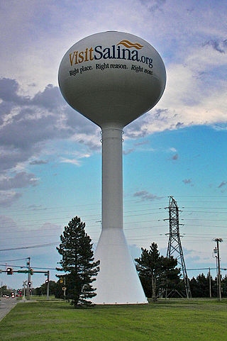
Salina is a city in and the county seat of Saline County, Kansas, United States. As of the 2020 census, the population was 46,889.

Hagåtña is the capital village of the United States territory of Guam. From the 18th through mid-20th century, it was Guam's population center, but today it is the second smallest of the island's 19 villages in both area and population. However, it remains one of the island's major commercial districts in addition to being the seat of government.

Apra Harbor, also called Port Apra, is a deep-water port on the western side of the United States territory of Guam. It is considered one of the best natural ports in the Pacific Ocean. The harbor is bounded by Cabras Island and the Glass Breakwater to the north and the Orote Peninsula in the south. Naval Base Guam and the Port of Guam are the two major users of the harbor. It is also a popular recreation area for boaters, surfers, scuba divers, and other recreationalists.

The Salinas Valley is one of the major valleys and most productive agricultural regions in California. It is located west of the San Joaquin Valley and south of San Francisco Bay and the Santa Clara Valley.

The Salinas River is the longest river of the Central Coast region of California, running 175 miles (282 km) and draining 4,160 square miles (10,800 km2). It flows north-northwest and drains the Salinas Valley that slices through the central California Coast Ranges south of Monterey Bay. The river begins in southern San Luis Obispo County, originating in the Los Machos Hills of the Los Padres National Forest. From there, the river flows north into Monterey County, eventually making its way to connect with the Monterey Bay, part of the Pacific Ocean, approximately 5 miles (8.0 km) south of Moss Landing. The river is a wildlife corridor, and provides the principal source of water from its reservoirs and tributaries for the farms and vineyards of the valley.
Salinas River may refer to:

Yona is a village in the United States territory of Guam.
ElDorado is an American manufacturer of cutaway buses, owned by Forest River, with its headquarters and main factory in Salina, Kansas.

Salinas del Manzano is a city of Spain in the province of Cuenca in the autonomous community of Castile-La Mancha. It has an area of 33.65 km2 with population of 105 inhabitants and a population density of 3.21 inhabitants / km2.
Salinas River National Wildlife Refuge is located approximately 11 miles north of Monterey, California, and 3 miles south of Castroville, California, at the point where the Salinas River empties into Monterey Bay. The 367-acre (1.49 km2) refuge encompasses several habitat types including sand dunes, pickleweed salt marsh, river lagoon, riverine habitat, and a saline pond. The refuge was established in 1974 because of its "particular value in carrying out the national migratory bird management program."

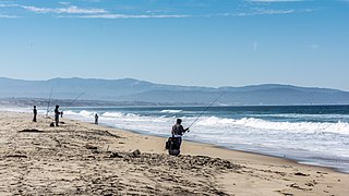
Salinas River State Beach is a beach at the river mouth of the Salinas River at Monterey Bay, in Monterey County, California.
The Tamolan languages are a small family of clearly related languages spoken in the region of the Guam River in Madang Province, Papua New Guinea.

The Agat World War II Amtrac is an underwater relic of World War II, located off Ga'an Point in Agat Bay on the west side of the island of Guam. It is the remains of an LVT 4, an amphibious tracked landing vehicle. It is located about 500 yards (460 m) off Agat Invasion Beach in 45 feet (14 m) of water, and was described as being in good condition when it was discovered and surveyed in 1985. These vehicles were used during the 1944 Battle of Guam, in which American forces recaptured the island from occupying Japanese forces. This particular vehicle does not appear to exhibit significant war damage. This is the most intact of the three Amtracks remaining on Guam from the 850 that participated in the battle. It was re-surveyed by maritime archaeological field schools conducted from 2009 to 2012.
John Forsythe Ashby was an American bishop in the Episcopal Church.
The River Road Wine Trail is a Salinas Valley roadway trail for wine-tasting following the River Road along the western banks of the Salinas River (California). It is not to be confused with the Great River Road Wine Trail that follows along the banks of the Mississippi River. It is notably referenced in numerous books and magazines.
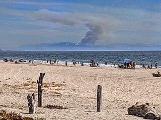
The River Fire was a wildfire that broke out from a lightning storm early on August 16, 2020 in Monterey County, California, south of Salinas, near River Road and Mount Toro. Within its first day, it spread to 2,000 acres and was 10% contained; mandatory evacuations were ordered, while air and ground crews worked the fire.

Neponset is an unincorporated community in Monterey County, California. It is located along the Southern Pacific Railroad and California State Route 1 between Marina, California and Castroville, California, and 8.5 miles (14 km) northwest of Salinas, California, at an elevation of 23 feet.