Fern is a town in Florence County, Wisconsin, United States. The population was 153 at the 2000 census. The unincorporated community of Fern is located in the town.

The U.S. Army Natick Soldier Research, Development and Engineering Center (NSRDEC), also known as the U.S. Army Natick Soldier Systems Center (NSSC), or simply as Natick Labs, is an element of the United States Army Research, Development, and Engineering Command (RDECOM), headquartered at Aberdeen Proving Ground, Maryland, and a tenant unit on the installation of the U.S. Army Soldier Systems Center (SSC) at Natick, Massachusetts.
Berriozar is a town located in the province of Navarre, in the autonomous community of Navarre, in the North of Spain. It is 6 km from Pamplona, forming part of Pamplona's metropolitan area. Berriozar's population in 2013 was 9.605 people.

KLXX, known as "Super Talk 1270", is a radio station located midway between Mandan and Bismarck, North Dakota, United States. It has always been licensed to Mandan, although most of its audience is in neighboring Bismarck.

Wheelerville is an unincorporated community in northeastern Barry County, Missouri, United States. It is located on Route 248, eleven miles northwest of Galena.
The South Branch of the Baker River is a 15.6-mile-long (25.1 km) river located in western New Hampshire in the United States. It is a tributary of the Baker River, part of the Pemigewasset River and Merrimack River watersheds.

Lewis College of Business was an institution of higher education in Detroit, Michigan in the United States. It was also the first historically black college in Michigan. Founded in 1928, it specialized in business-related topics. The school closed in 2013. Founder: Violet T Lewis.The school was the location of the founding of Gamma Phi Delta Sorority, Eta Phi Beta sorority and Tau Gamma Delta Sorority.
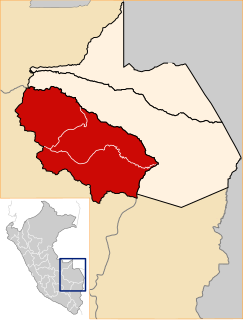
Monterroso is a municipality in Lugo province in Galicia in north-west Spain.

San Vicente de Alcántara is a municipality in the province of Badajoz, Extremadura, Spain. It has a population of 5,788 and an area of 275 km².

Wentworth is an unincorporated community, in the town of Amnicon, Douglas County, Wisconsin, United States.
Island Lakes is a neighbourhood in the southeast corner of city of Winnipeg, Manitoba, Canada, that was developed by Novamet Development Corporation.

Dąbie is a settlement in the administrative district of Gmina Płoty, within Gryfice County, West Pomeranian Voivodeship, in north-western Poland. It lies approximately 8 kilometres (5 mi) north-east of Płoty, 14 km (9 mi) south-east of Gryfice, and 71 km (44 mi) north-east of the regional capital Szczecin.

Manuel Mill is an unincorporated community in Calaveras County, California. It lies at an elevation of 3750 feet.
Nouaceur is a municipality and the administrative capital of Nouaceur Province in the Casablanca-Settat region of Morocco. At the 2004 census it had a population of 12,696.
KNLH is a radio station licensed to Cedar Hill, Missouri, United States. The station broadcasts a Religious format as an affiliate of Here's Help Network, and is owned by New Life Evangelistic Center.
La Panza, a populated place, formerly a gold boom town, in San Luis Obispo County, California. It lies in the La Panza Range at an elevation of 1880 feet (573m). La Panza derives from a Spanish word for paunch of beef, that Californio hunters used to lure bears. The location was recorded in 1828, with the name paraje la panza.
Lone Tree is an unincorporated community in Cass County, in the U.S. state of Missouri.
Dockery is an unincorporated community in Ray County, in the U.S. state of Missouri.

Oak Grove is an unincorporated community in Point Township, Posey County, in the U.S. state of Indiana.