Sierra Leone first became inhabited by indigenous African peoples at least 2,500 years ago. The Limba were the first tribe known to inhabit Sierra Leone. The dense tropical rainforest partially isolated the region from other West African cultures, and it became a refuge for peoples escaping violence and jihads. Sierra Leone was named by Portuguese explorer Pedro de Sintra, who mapped the region in 1462. The Freetown estuary provided a good natural harbour for ships to shelter and replenish drinking water, and gained more international attention as coastal and trans-Atlantic trade supplanted trans-Saharan trade.

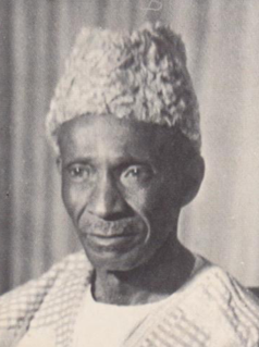
Sir Milton Augustus Strieby Margai was a Sierra Leonean medical doctor and politician who served as the country's head of government from 1954 until his death in 1964. He was titled chief minister from 1954 to 1960, and then prime minister from 1961 onwards. Margai studied medicine in England, and upon returning to homeland became a prominent public health campaigner. He entered politics as the founder and inaugural leader of the Sierra Leone People's Party. Margai oversaw Sierra Leone's transition to independence, which occurred in 1961. He died in office aged 68, and was succeeded as prime minister by his brother Albert. Margai enjoyed the support of Sierra Leoneans across classes, who respected his moderate style, friendly demeanor, and political savvy.

The Mende are one of the two largest ethnic groups in Sierra Leone; their neighbours, the Temne people, constitute the largest ethnic group at 35.5% of the total population, which is slightly larger than the Mende at 31.2%. The Mende are predominantly found in the Southern Province and the Eastern Province, while the Temne are found primarily in the Northern Province and the Western Area, including the capital city of Freetown. Some of the major cities with significant Mende populations include Bo, Kenema, Kailahun, and Moyamba.

Bo, also commonly referred to as Bo Town, is the second largest city in Sierra Leone by landscape/geographical location and the largest city in the Southern Province. Bo is the capital and administrative centre of Bo District. The city of Bo had a population of 149,957 in the 2004 census and had a population of about 233,684 based on 2017 estimate. Bo is an urban centre, and lies approximately 160 miles (250 km) eastsoutheast of Freetown, and about 40 miles (71 km) to Kenema. Bo is the leading financial, educational and economic centre of southern Sierra Leone.

Kailahun is the capital of Kailahun District in the Eastern Province of Sierra Leone. Kailahun is a major business and commercial center of Kailahun District. The population was 13,108 in the 2004 census, a 2006 estimate of 18,411 and a current estimate of about 30,411. Kailahun lies in the far east of Sierra Leone, approximately 200 miles east of Freetown, about 51 miles north east of Kenema, and near the border of Liberia.
The Kamajors were a group of traditional hunters from the Mende ethnic group in the south and east of Sierra Leone. The word "Kamajor" derived from Mende "kama soh", meaning traditional hunter with mystical powers, who were originally employed by local chiefs.

Bonthe District is a district that comprises several islands and mainland of the Atlantic Ocean in the Southern Province of Sierra Leone. Bonthe is one of the sixteen districts of Sierra Leone. Its capital is the town of Mattru Jong and its largest city is Bonthe, on Sherbro Island. As of the 2015 census, the district had a population of 200,730. Bonthe District is one of the sixteen districts of Sierra Leone. Bonthe District is subdivided into eleven chiefdoms.
The Sherbro people are a native people of Sierra Leone, who speak the Sherbro language; they make up 1.9% of Sierra Leone's population or 134,606. The Sherbro are found primarily in their homeland in Bonthe District, where they make up 40% of the population, in coastal areas of Moyamba District, and in the Western Area of Sierra Leone, particularly in Freetown. During pre-colonial days, the Sherbro were one of the most dominant ethnic group in Sierra Leone, but in the early 21st century, the Sherbro comprise a small minority in the nation. The Sherbro speak their own language, called Sherbro language.

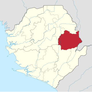
Kono District is a district in the Eastern Province of Sierra Leone. Its capital and largest city is Koidu Town. Motema is the second most populous city in the district. The other major towns in the district include Yengema, Tombodu, Jaiama Nimikor and Sewafe. The district is the largest diamond producer in Sierra Leone. The population of Kono District is 505,767. Kono District borders Kenema District to the southwest, The Republic of Guinea to the east, Koinadugu District to the northeast and Kailahun District to the southeast. Kono District is divided into fourteen chiefdoms.
Kambia also commonly known as Kambia Town is the capital and largest town of Kambia District in the Northern Province of Sierra Leone. Kambia is a major trading town; and lies approximately 120 miles north-east of Freetown. The town had a population of 11,842 in the 2004 census, with a 2010 estimate being 12,471 and a current estimate of 40,000. Kambia is a major trading route along the main highway linking Sierra Leone's capital Freetown to Conakry, the capital of Guinea.

Pendembu is a town in Kailahun District in the Eastern Province of Sierra Leone. The town population was 7,243 at the 2004 census but increased to 20,502 according to a more recent estimate. Pendembu lies approximately 36 miles from Kenema and about 235 east of Freetown. Pendembu is a trade center and is one of the main towns in Eastern Sierra Leone.
Waterloo is a city in the Western Area of Sierra Leone and the capital of the Western Area Rural District, which is one of the sixteen districts of Sierra Leone. Waterloo is located about twenty miles east of Freetown. Waterloo is the second largest city in the Western Area region of Sierra Leone, after Freetown. The city had a population of 34,079 in the 2004 census, and 55,000 as per a 2015 estimate. Waterloo is part of the Freetown metropolitan area.

The Mende Kikakui script is a syllabary used for writing the Mende language of Sierra Leone.
The Kono people are a major Mande-speaking ethnic group in Sierra Leone at 5.2% of the country's total population. Their homeland is the diamond-rich Kono District in eastern Sierra Leone. The Kono are primarily diamond miners and farmers.
Pujehun is the capital of Pujehun District in the Southern Province. The current estimate of the population of Pujehun is 20,121 people.
Segbwema is a town in Kailahun District in the Eastern Province of Sierra Leone. The town is a major business and agricultural centre. Segbwema lies approximately 20 miles northeast of Kenema and about 225 miles south-east of Freetown. The population of Segbwema was 7,961 in the 2004 census with a current estimate of 16,532.
Mattru Jong commonly known as Mattru is the capital of Bonthe District in the Southern Province of Sierra Leone. Mattru Jung is located on the mainland of Bonthe District, along the Jong River, 52 miles southwest of Bo. The town is the seat of Mongerewa Jong Chiefdom, and is the home of Mongerewa Jong Paramount Chief Alie Badara Sheriff III. The town's current estimated population is about 20,000 people. In 2010 it was 8,199, and in the 2004 census the town had a population of 7,647.
https://www.facebook.com/groups/KALANGBAFAMBULFile:Question+book-new.svgThis+article+needs+additional+citations+for+verification.+Please+help+improve+this+article+by+adding+citations+to+reliable+sources.+Unsourced+material+may+be+challenged+and+removed.Find+sources: %22Kalangba%22 – news ·+newspapers ·+books ·+scholar ·+JSTOR++(November+2010)+(Learn+how+and+when+to+remove+this+template+message)
Tissana is a coastal village near the city of Waterloo in the Western Area Rural District of Sierra Leone. Tissana village is near the neighborhood village of Russell along the Freetown-Waterloo highway. The major economic activities in Tissana are the processing of salt, palm oil, and tourism.

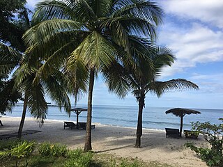
Tokeh Also known as Tokeh Town is a coastal resort town along the peninsula in the Western Area Rural District of Sierra Leone. Tokeh lies approximately twenty miles east of Freetown and near the neighborhood town of York. The major economic activity in Tokeh is fishing and tourism.


