San Anton (known also as Getaria's mouse because of its form), is the mountain and half-island located off the coast of Getaria, Gipuzkoa, Spain. San Anton is attached to the mainland by a breakwater. It has an abrupt slope, and is one of the most popular places of Basque Country. It is used principally for recreation by the local population. The mountain has a natural park. The top of the mountainside is flatter, and it is decorated by trees. Its precipice is formed with rocks, specially with one called Armeria euskadiensis.
San Anton mountain
San Anton mountain takes its name from an ancient hermitage, which was located near the actual lighthouse before it was destroyed by the French in the first half of 19th century. It was a privileged vantage point to see whales, whose capture was one of the jobs of people from this town.
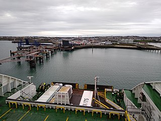
This island was intentionally attached to the port in the 15th century. The breakwater was given the name of "The Passage" in order to complete the construction of a small harbor for the mountain-island, replacing the old rocky ridge that had been destroyed by a storm. Fortifications, an 1863 lighthouse and farmhouses like Abeta, Agoteaundi and Gure ametsa decorate San Anton.
Pebble Island is one of the Falkland Islands, situated north of West Falkland. It is possibly named after the peculiarly spherical pebbles found at its western tip.
Concrete ships are built primarily with ferrocement hulls, reinforced with steel bars. This contrasts against more traditional materials, such as pure steel or wood. The advantage of ferrocement construction is that materials are cheap and readily available, while the disadvantages are that construction labor costs are high, as are operating costs. During the late 19th century, there were concrete river barges in Europe, and during both World War I and World War II, steel shortages led the US military to order the construction of small fleets of ocean-going concrete ships, the largest of which was the SS Selma. United States Maritime Administration (MARAD) designation for concrete ships-barges was Type B ship. Few concrete ships were completed in time to see wartime service during World War I, but during 1944 and 1945, concrete ships and barges were used to support U.S. and British invasions in Europe and the Pacific. Since the late 1930s, there have also been ferrocement pleasure boats.
Saint Peter Port Harbour is located in Saint Peter Port, Guernsey. It was a natural anchorage used by the Romans which has been changed into an artificial harbour that is now the island's main port for passengers. Loose cargo, liquids and gas are shipped to and from St Sampson's harbour.
South Stack is an island situated just off Holy Island on the northwest coast of Anglesey, Wales.
Grip is an archipelago and deserted fishing village in Møre og Romsdal county, Norway. It is located about 14 km (9 mi) northwest of the town of Kristiansund in the Norwegian Sea. The Grip Lighthouse, one of the tallest lighthouses in Norway, is located on one of the islands of Grip. The historic Grip Stave Church is located on the island of Gripholmen. From 1897 until 1964, the islands were part of Grip Municipality, but the islands were merged into Kristiansund Municipality in 1964.
Mauna Ulu is a volcanic cone in the eastern rift zone of the Kīlauea volcano on the island of Hawaii. It falls within the bounds of Hawaiʻi Volcanoes National Park. Mauna Ulu was in a state of eruption from May 1969 to July 1974.
San Antonio del Monte is also a subdivision of Garafía in the island of La Palma in the Canary Islands
Getaria is a town on the Urola coast, in the province of Gipuzkoa, in the autonomous community of the Basque Country, in northern Spain. It borders Zarautz to the east and Zumaia to the west.
Ireland Island is the north-westernmost island in the chain which comprises Bermuda. It forms a long finger of land pointing northeastwards from the main island, the last link in a chain which also includes Boaz Island and Somerset Island. It lies within Sandys Parish, and forms the northwestern coast of the Great Sound. It is regarded as one of the six principal islands of Bermuda, and part of the West End of the archipelago.
Salt Island is joined to Holy Island, Anglesey, in North Wales. It is a natural provider of shelter for the town's Old Harbour from the Irish Sea and is part of the Port of Holyhead.
Saybrook Breakwater Lighthouse is a sparkplug lighthouse in Connecticut, United States, at Fenwick Point at the mouth of the Connecticut River near Old Saybrook, Connecticut. It is featured on the state's "Preserve the Sound" license plates.
Santa Maria del Campo is a town and municipality in the Province of Burgos, Spain. The village is in the wine region known as Ribera del Arlanza, 22 km from Lerma.
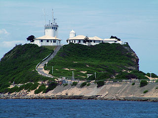
Nobbys Head is a headland located on the southern entrance to Newcastle Harbour, New South Wales, Australia. The headland is situated above the Hunter River and the Tasman Sea of the South Pacific Ocean.
Cabrillo Beach is a historic public beach located in San Pedro, Los Angeles, California. It is named after Juan Rodríguez Cabrillo, a Spanish explorer who was the first to sail up the California coast. Cabrillo has two separate beach areas.
Txakoli de Getaria - Getariako Txakolina is a Spanish Denominación de Origen Protegida (DOP) for wines, located around the towns of Getaria and Zarautz, small fishing towns on the coast of the Bay of Biscay, in the province of Gipuzkoa, Basque Country, Spain. A small amount of grapes are also grown around the town of Aia.
Holyhead Breakwater is situated at the north-western end of Holyhead in Anglesey in North Wales. The Victorian structure, which is 1.7 miles (2.7 km) long, is the longest breakwater in the United Kingdom. The breakwater, which is accessible in good weather, has a promenade on top which leads out to the Holyhead Breakwater Lighthouse.
The Basques were among the first people to catch whales commercially rather than purely for subsistence and dominated the trade for five centuries, spreading to the far corners of the North Atlantic and even reaching the South Atlantic. The French explorer Samuel de Champlain, when writing about Basque whaling in Terranova, described them as "the cleverest men at this fishing". By the early 17th century, other nations entered the trade in earnest, seeking the Basques as tutors, "for [they] were then the only people who understand whaling", lamented the English explorer Jonas Poole.
The North Mole is a breakwater located in the northern section of Gibraltar Harbour, in the British Overseas Territory of Gibraltar, at the southern end of the Iberian Peninsula. The North Mole, with the rest of harbour, is just north of the east entrance to the Strait of Gibraltar. The breakwater was formerly known as the Commercial Mole, and is the site of the commercial port in the harbour. It was the consequence of a late nineteenth century plan by the British Admiralty to create a modern dockyard and large defensive harbour in Gibraltar.
Fuerte de Isla Verde was a military installation formerly located in Algeciras, Spain. It occupied the Isla Verde, which gave its name to the city as a whole. The elongated island, which stood a short distance offshore of the city's old town, was already the site of an artillery battery in 1720. In 1734 the fort was constructed on the island to the plans of the military engineer Juan de Subreville. Further remodeling took place in 1745 under Lorenzo de Solís. The installation, which followed the roughly triangular shape of the island, was initially equipped with three batteries. These were:
The Maspalomas Lighthouse is an active 19th century lighthouse at the southern end of the Spanish island of Gran Canaria, in the Canary archipelago. It lies at one end of the Maspalomas beach, 4 kilometres (2.5 mi) south of the resort town centre, next to the area known as the Maspalomas Dunes.
This page is based on this Wikipedia article Text is available under the CC BY-SA 4.0 license; additional terms may apply. Images, videos and audio are available under their respective licenses.