
Tlacotalpan is a city in Tlacotalpan Municipality in the Mexican state of Veracruz, declared a World Heritage Site by UNESCO in 1998 primarily for its architecture and colonial-era layout. The town was established in 1550 on what was originally an island in the Papaloapan River. From the colonial era to the 20th century, it was an important port, one of few interior river ports in Latin America. However, with the construction of the railroad, Tlacotalpan's importance faded. Starting in the latter 20th century, efforts to conserve the city's Spanish/Caribbean architecture and layout began, culminating in World Heritage status. Today, its main economic support is fishing and tourism, especially to the annual feast in honor of Our Lady of Candlemas.

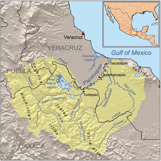
The Papaloapan River is one of the main rivers of the Mexican state of Veracruz. Its name comes from the Nahuatl papaloapan meaning "river of the butterflies".

The Sierra Madre de Oaxaca is a mountain range in southern Mexico. It is primarily in the state of Oaxaca, and extends north into the states of Puebla and Veracruz.

San Juan Bautista Tuxtepec, or simply referred to as Tuxtepec, is the head of the municipality by the same name and is the second most populous city of the Mexican state of Oaxaca. It is part of the Tuxtepec District of the Papaloapan Region. As of the 2020 census, the city is home to a population of 103,609 and 159,452 in the municipality, though census data are often under reported for various reasons.
Saltabarranca is a municipality located in the south zone of the Mexican state of Veracruz, about 180 kilometres (110 mi) from the state capital Xalapa. It has an area of 91.3 km2 (35.3 sq mi). It is located at 18°22′N95°48′W.
San Juan Bautista Valle Nacional is a town and municipality in Oaxaca in south-western Mexico. The municipality covers an area of 394.23 km² within the Sierra Juárez mountains. It is part of the Tuxtepec District of the Papaloapan Region. The town lies on the north bank of the Valle Nacional River, a tributary of the Papaloapan River.
San Juan Evangelista is a municipality located in the plains of the Sotavento zone in the central zone of the Mexican state of Veracruz, about 260 km from the state capital Xalapa. It has a surface of 968.94 km2. It is located at 17°53′N95°08′W.
Sayula is a municipality located in the plains of the Sotavento zone in the central zone of the Mexican state of Veracruz, about 382 km from the state capital Xalapa. It has a surface area of 640.76 km2 (247 sq mi). It is located at 17°53′N94°57′W.
Texhuacán is a municipality located in the montane central zone in the Mexican state of Veracruz, about 205 km from the state capital Xalapa. It has a surface of 32.90 km2. It is located at 18°37′N97°02′W.
The Amapa River is a river in the Mexican states of Oaxaca and Veracruz.
The Valle Nacional River is a river of Oaxaca state in Mexico. The river originates in the Sierra Juárez. The ecology of the region, originally one of pine forests, is threatened by logging, agriculture and grazing. The Valle Nacional flows past San Juan Bautista Valle Nacional, and joins the Santo Domingo River to the southwest of San Juan Bautista Tuxtepec to form the Papaloapan River.
The Trinidad River (Mexico) is a river of Oaxaca state in Mexico.
The Salado River is a river in the states of Puebla and Oaxaca in Mexico.
The Lalana River is a river of Oaxaca and Veracruz states of Mexico.
The Cerro de Oro Dam, also called the Miguel de la Madrid Hurtado Dam, is on the Santo Domingo River in the San Juan Bautista Tuxtepec municipality of the Papaloapan Region of Oaxaca state in southern Mexico. The dam operates in conjunction with the Miguel Alemán Dam, located on the Tonto River to control floods in the Papaloapan basin in Veracruz state. Construction began in 1973 and the dam was completed in May 1989. About 26,000 people were displaced by the project. Water quality in the reservoir is poor and deteriorating, affecting fish catches.
The Santo Domingo River, in the Mexican state of Oaxaca, is one of the main tributaries of the Papaloapan River. It is formed by the confluence of the Salado and Grande rivers, which drain the dry Tehuacán and Cuicatlán valleys west of the Sierra Madre de Oaxaca. The Santo Domingo river flows east through the Sierra Madre, dividing the Sierra Zongolica sub-range to the north from the Sierra Juárez to the south. It joins with the Valle Nacional River above San Juan Bautista Tuxtepec to form the Papaloapan.

The Miguel Alemán Dam is on the Tonto River in the Papaloapan Region of Oaxaca state in southern Mexico, just upstream from the town of Temascal or Nuevo Soyaltepec, forming the Miguel Alemán Lake with an area of 47,800 hectares. The dam operates in conjunction with the Cerro de Oro Dam, located on the Santo Domingo River to control floods in the Papaloapan basin in Veracruz state. Together with the 22,000 hectare reservoir of the Cerro de Oro, which is joined by a channel to the Miguel Alemán Lake, the combined capacity is 13,380 million cubic metres. The lake formed by the dam is scenic, providing income from fishing and tourism. The northwestern shore and islands have been declared a nature reserve. The dam includes the Temascal hydroelectric plant.

The Cuenca del Papaloapan Region is in the north of the state of Oaxaca, Mexico where the foothills of the Sierra Madre de Oaxaca meet the coastal plain of Veracruz. The principal city is San Juan Bautista Tuxtepec, the second largest in Oaxaca state.
Tuxtepec District is located in the north of the Papaloapan Region of the State of Oaxaca, Mexico.
