
Julian is a census-designated place (CDP) in San Diego County, California, in the United States. As of the 2010 census, the population was 1,502, down from 1,621 at the 2000 census.
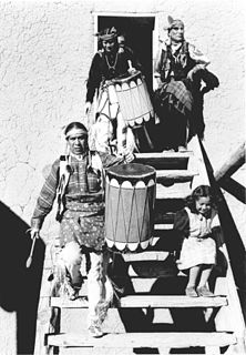
San Ildefonso Pueblo is a census-designated place (CDP) in Santa Fe County, New Mexico, United States, and a federally recognized tribe, established c. 1300 C.E. The Pueblo is self-governing and is part of the Santa Fe, New Mexico Metropolitan Statistical Area. The population was 524 as of the 2010 census, reported by the State of New Mexico as 1,524 in 2012, and there were 628 enrolled tribal members reported as of 2012 according to the Department of the Interior. San Ildefonso Pueblo is a member of the Eight Northern Pueblos, and the pueblo people are from the Tewa ethnic group of Native Americans, who speak the Tewa language.

Saint Julian's is a town in the Central Region of Malta. It is situated along the coast, north of the country's capital, Valletta. It is known for tourism-oriented businesses, such as hotels, restaurants and nightclubs which are centred mainly in an area known as Paceville.

Julián Castro is an American Democratic politician who served as the 16th United States Secretary of Housing and Urban Development under President Barack Obama from 2014 to 2017, the youngest member of the Obama Cabinet.

Uffculme is a village and civil parish located in the Mid Devon district, of Devon, England. Situated in the Blackdown Hills on the B3440, close to the M5 motorway and the Bristol–Exeter railway line, near Cullompton, Uffculme is on the upper reaches of the River Culm. The 2001 census recorded the population of the parish as 2,631. It is surrounded, clockwise from the north, by the parishes of Culmstock, Hemyock, Sheldon, Kentisbeare, Cullompton, Willand, Halberton and Burlescombe.
La Coipa District is one of seven districts of the province San Ignacio in Peru.
Statistics of 1. deild in the 1997 season.

The Kenton County Public Library is a library system serving the residents of Kenton County, Kentucky. The library ranked first in Kentucky in Hennen's American Public Library Ratings 2008.

Coacollo is a small town in Bolivia. In 2009 it had an estimated population of 736.

Bandera is a municipality and town in Santiago del Estero Province in Argentina. It is the capital of the Belgrano Department, at the edge of National Route 98. Bandera is located some 272 km from the provincial capital, which is reached by National Route No. 34 and Provincial Route No. 21. The town has 5,335 inhabitants, according to the 2001 census, 67% of the total population of the department.

Thorney Toll is a hamlet in Fenland District, in the Isle of Ely, Cambridgeshire, England. The hamlet sits either side of the A47 between Guyhirn and Peterborough. It is 12 miles from Wisbech. The population is included in the civil parish of Wisbech St Mary.
Bramante Staircase is the name given to two staircases in the Vatican Museums in the Vatican City State: the original stair, built in 1505, and a modern equivalent from 1932.

Branson City or Branson is a ghost town in San Diego County, California. It lies at an elevation of 3996 feet. It is located on State Highway 78 at its junction with Pine Hills Road, about one mile west of Julian.
Coleman City, also called Emily City, is a ghost town in San Diego County, California. It lies at an elevation of 3601 feet. It is located on State Highway 78 where it crosses Coleman Creek, about four miles west of Julian.
The Church of Our Lady of Sorrows and Saint Isidore the Laborer is a Roman Catholic parish church in Libertad, San José Department, Uruguay.
Stadion dr. Antoine Maduro is a multi-use stadium in Willemstad, Curaçao. It is currently used mostly for football matches and is the home stadium of S.V. SUBT. It has a capacity of 7,000 spectators. It is located on Vesuviusstraat, a road off Dr. Martin Luther King Boulevard, to the south of the main harbor in Willemstad.
Mine La Motte Township is an inactive township in Madison County, in the U.S. state of Missouri.
Jardin de San Julian is a census-designated place (CDP) in Starr County, Texas, United States. This was a new CDP for the 2010 census with a population of 22.

San Julián is a city and the fourth municipal section of Ñuflo de Chávez Province in Santa Cruz Department, Bolivia. This municipality is mostly populated by migrants from other regions of Bolivia, and in a lesser amount by local indigenous inhabitants of the Guaraní ethnicity. It's a zone with a high agricultural productivity for soy, sunflower, corn, rice, beans, and sesame based on the quality of its soils.

