
Emery County is a county in east-central Utah, United States. As of the 2010 United States Census, the population was 10,976. Its county seat is Castle Dale, and the largest city is Huntington.

A natural arch, natural bridge, or rock arch is a natural rock formation where an arch has formed with an opening underneath. Natural arches commonly form where inland cliffs, coastal cliffs, fins or stacks are subject to erosion from the sea, rivers or weathering.

The Entrada Sandstone is a formation in the San Rafael Group found in the U.S. states of Wyoming, Colorado, northwest New Mexico, northeast Arizona, and southeast Utah. Part of the Colorado Plateau, this formation was deposited during the Jurassic Period sometime between 180 and 140 million years ago in various environments, including tidal mudflats, beaches, and sand dunes. The Middle Jurassic San Rafael Group was dominantly deposited as ergs in a desert environment around the shallow Sundance Sea.
Interstate 580 (I-580) is an approximately 82-mile-long (132 km) east–west auxiliary Interstate Highway in Northern California. The heavily traveled spur route of I-80 runs from US 101 in San Rafael in the San Francisco Bay Area to I-5 near Tracy in the Central Valley. I-580 forms a concurrency with I-80 between Albany and Oakland, the latter of which is the location of the MacArthur Maze interchange immediately east of the San Francisco–Oakland Bay Bridge. I-580 provides a connection from the Bay Area to the southern San Joaquin Valley and Southern California via I-5, as I-5 bypasses the Bay Area to the east.
San Juan River may refer to:
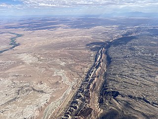
The San Rafael Swell is a large geologic feature located in south-central Utah, United States about 16 miles (26 km) west of Green River. The San Rafael Swell, measuring approximately 75 by 40 miles, consists of a giant dome-shaped anticline of sandstone, shale, and limestone that was pushed up during the Paleocene Laramide Orogeny 60–40 million years ago. Since that time, infrequent but powerful flash floods have eroded the sedimentary rocks into numerous valleys, canyons, gorges, mesas, buttes, and badlands.

The Richmond–San Rafael Bridge is the northernmost of the east–west crossings of the San Francisco Bay in California, USA. Officially named after California State Senator John F. McCarthy, it bridges Interstate 580 from Richmond on the east to San Rafael on the west. It opened in 1956, replacing ferry service by the Richmond–San Rafael Ferry Company.

Joseph Sadoc Alemany y Conill, O.P. was a Spanish Roman Catholic archbishop and missionary. He served as the first Bishop of Monterey from 1850 until 1853, and as the first Archbishop of San Francisco from 1853 until 1884.

The North Bay is a subregion of the San Francisco Bay Area, in California, United States. The largest city is Santa Rosa, which is the fifth-largest city in the Bay Area. It is the location of the Napa and Sonoma wine regions, and is the least populous and least urbanized part of the Bay Area. It consists of Marin, Napa, Solano and Sonoma counties.
Richmond Bridge may refer to:

The MacArthur Maze is a large freeway interchange near the east end of the San Francisco–Oakland Bay Bridge in Oakland, California. It splits Bay Bridge traffic into three freeways—the Eastshore (I-80/I-580), MacArthur (I-580) and Nimitz (I-880).
Interstate 180 may refer to:
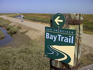
The San Francisco Bay Trail is a bicycle and pedestrian trail that when finished will allow continuous travel around the shoreline of San Francisco Bay. As of 2020, 356 miles (573 km) of the trail have been completed. When finished, the trail will be over 500 miles (800 km) of paved and gravel paths, bike lanes, and sidewalks, linking 47 cities across nine counties and crossing seven toll bridges. It is a project of the Association of Bay Area Governments (ABAG) and the Metropolitan Transportation Commission (MTC), in collaboration with other agencies, private companies, non-profit organizations, and advocacy groups.
Devil's Canyon may refer to:
Interstate 70 (I-70) is a mainline route of the Interstate Highway System in the United States connecting Utah and Maryland. The Utah section runs east–west for approximately 232 miles (373 km) across the central part of the state. Richfield is the largest Utah city served by the freeway, which does not serve or connect any urban areas in the state. The freeway was built as part of a system of highways connecting Los Angeles and the northeastern United States. I-70 was the second attempt to connect southern California to the east coast of the United States via central Utah, the first being a failed attempt to construct a transcontinental railroad. Parts of that effort were re-used in the laying out of the route of I-70.
State Route 22 (SR-22) is a state highway in southern Utah, running for 6.852 miles (11.027 km) in Garfield and Piute Counties from Antimony to Otter Creek Reservoir.

The Richmond–San Rafael Ferry Company (originally Richmond–San Rafael Ferry and Transportation Company was a ferry service between Castro Point in Richmond, California in Contra Costa County and San Quentin in Marin County across the San Pablo Bay. It ran from 1915 until the 1956 opening of the Richmond–San Rafael Bridge.

The San Rafael Bridge is a historic suspension bridge over the San Rafael River in central Emery County, Utah, United States, that is listed on the National Register of Historic Places (NRHP).