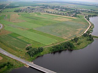
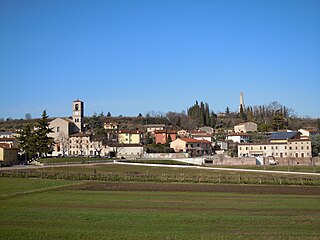
Santa Lucia was an ancient paesino next to Verona (its parish is still called Santa Lucia extra, since it is positioned outside the ancient town wall). Today it has been absorbed into Verona, located to the south-west of the city centre, forming part of the Circoscrizione 4 of the Commune of Verona.
Circoscrizione can refer to two different administrative units of Italy. One is an electoral district approximating to the English constituency but typically the size of a province or region depending on the election. The other is a subdivision of city comuni roughly equivalent to the municipal arrondissements of Paris or the London boroughs.
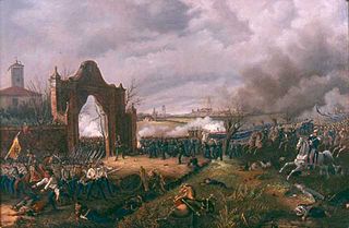
The battle of Santa Lucia was an episode in the First Italian War of Independence. On 6 May 1848, when the king of Sardinia, Carlo Alberto, sent I Corps of the Sardinian army to assault the fortified positions held before the walls of Verona by the Austrian army under field marshal Josef Radetzky. The Austrian army, though outnumbered, managed to withstand the attack and hold their positions. The battle is named after the Santa Lucia district of Verona. Franz Joseph assisted at the battle.
The First Italian War of Independence was part of the Italian unification or Risorgimento. It was fought by the Kingdom of Sardinia (Piedmont) and Italian volunteers against the Austrian Empire and other conservative states from 23 March 1848 to 22 August 1849 in the Italian peninsula.
Dossobuono is a town in the Veneto, in northeast Italy. It is a frazione of the comune of Villafranca di Verona, in the province of Verona. It has a population of around 6400.
In the 1950s this district and that of Golosine were the subject of rapid urbanisation, uniting it to the city thanks to the construction of numerous popular residential houses, whose offshoots extended as far as the industrial, food, customs and agriculture zones.
A geographic coordinate system is a coordinate system that enables every location on Earth to be specified by a set of numbers, letters or symbols. The coordinates are often chosen such that one of the numbers represents a vertical position and two or three of the numbers represent a horizontal position; alternatively, a geographic position may be expressed in a combined three-dimensional Cartesian vector. A common choice of coordinates is latitude, longitude and elevation. To specify a location on a plane requires a map projection.
Related Research Articles
Lucia of Syracuse (283–304), also known as Saint Lucy or Saint Lucia, was a Christian martyr who died during the Diocletianic Persecution. She is venerated as a saint by the Roman Catholic, Anglican, Lutheran, and Orthodox Churches. She is one of eight women along with the Blessed Virgin Mary who are commemorated by name in the Canon of the Mass. Her feast day, known as Saint Lucy's Day, is celebrated in the West on 13 December. St. Lucia of Syracuse was honored in the Middle Ages and remained a well-known saint in early modern England.
Cannaregio is the northernmost of the six historic sestieri (districts) of Venice. It is the second largest sestiere by land area and the largest by population, with 13,169 people as of 2007.
The Province of Verona is a province in the Veneto region of Italy. The eastern bank of Lake Garda is near the province. Its capital is the city of Verona. The city is a UNESCO World Heritage Site. The province is cosmopolitan in nature. It is bordered by Italian Tyrol in the north, Province of Vicenza and Province of Padua in the east. Province of Rovigo and Province of Mantua in south and Lake Garda in the west. From north to south the maximum extent of the province is 50 miles while it is 25 miles from east to west.
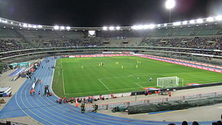
The Stadio Marcantonio Bentegodi is a stadium in Verona, Italy. It is the home of Hellas Verona and ChievoVerona of Serie B and Serie A, respectively. It also hosts the Women's Champions League matches of Bardolino Verona, some youth team matches, rugby matches, athletics events and occasionally even musical concerts. With 39,211 total seats, of which only 31,045 are approved, it is the eighth-largest stadium in Italy by capacity. The stadium is named after the historic benefactor of Veronese sport, Marcantonio Bentegodi.
Kėdainiai District Municipality is one of 60 municipalities in Lithuania.
Saint Lucia is an island country in the Caribbean.
Events in the history of Verona, in Italy.
Hüyük, also Höyük, is a town and district of Konya Province in the Central Anatolia region of Turkey. According to 2000 census, population of the district is 52,110 of which 8,472 live in the town of Hüyük.
Kaloša is a village and municipality in the Rimavská Sobota District of the Banská Bystrica Region of southern Slovakia.
Venezia Santa Lucia is the central station of Venice in the north-east of Italy. It is a terminus and located at the northern edge of Venice's historic city . The station is one of Venice's two most important railway stations; the other one is Venezia Mestre, a mainline junction station on Venice's mainland district of Mestre. Both Santa-Lucia and Mestre stations are managed by Grandi Stazioni and they are connected to each other by Ponte della Libertà.
Santa Lucía del Camino is a city and its surrounding municipality located in the central part of the Mexican state of Oaxaca. It lies just 3 km east of the state capital city of Oaxaca, within the Oaxaca metropolitan area. It is part of the Centro District in the Valles Centrales region.
Villoslada is a municipality located in the countryside Syracuse in Castilla y Leon, Spain.
Kubczyce is a settlement in the administrative district of Gmina Dobiegniew, within Strzelce-Drezdenko County, Lubusz Voivodeship, in western Poland.
Adriatic Bridge is a six-lane road and tram bridge over the Sava River in Zagreb, Croatia.
Custoza is a northern Italian village and hamlet (frazione) of Sommacampagna, a municipality in the province of Verona, Veneto. As of 2011, its population was 812.
San Giorgio in Braida is a Roman Catholic church in Verona, region of Veneto, Italy. A church titled San Giacomo in Braida, was located in Cremona, and became superseded by Sant'Agostino.
Santa Lucia was a church in Venice, northern Italy, which was demolished in 1861.
Montelaterone is a village in Tuscany, central Italy, administratively a frazione of the comune of Arcidosso, province of Grosseto, in the area of Mount Amiata. At the time of the 2001 census its population amounted to 283.
Santa Lucia or Santa Lucia dè Magnoli is a Roman Catholic church located on via de'Bardi in Oltrarno district of Florence, region of Tuscany, Italy.
This page is based on this Wikipedia article Text is available under the CC BY-SA 4.0 license; additional terms may apply. Images, videos and audio are available under their respective licenses.