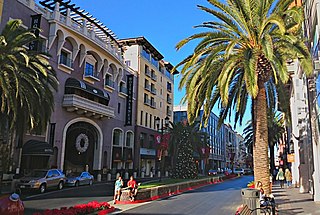
San Jose, officially the City of San José, is the largest city in Northern California by both population and area. With a 2022 population of 971,233, it is the most populous city in both the Bay Area and the San Jose–San Francisco–Oakland Combined Statistical Area—which in 2022 had a population of 7.5 million and 9.0 million respectively—the third-most populous city in California after Los Angeles and San Diego, and the 13th-most populous in the United States. Located in the center of the Santa Clara Valley on the southern shore of San Francisco Bay, San Jose covers an area of 179.97 sq mi (466.1 km2). San Jose is the county seat of Santa Clara County and the main component of the San Jose–Sunnyvale–Santa Clara Metropolitan Statistical Area, with an estimated population of around two million residents in 2018.
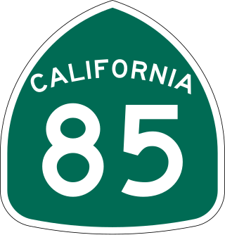
State Route 85 is a state highway which connects the cities of southern San Jose and Mountain View in the U.S. State of California. The highway intersects with major highways such as I-280, SR 17, and SR 87. The route serves as a bypass of U.S. Route 101 in the Santa Clara Valley area, running through the foothill cities of Los Gatos, Saratoga, Cupertino, roughly paralleling the Santa Cruz Mountains up to its interchange with I-280.

Almaden Valley, commonly known simply as Almaden, is a valley and neighborhood of San Jose, California, located in South San Jose. It is nestled between the Santa Cruz Mountains to the west and the Santa Teresa Hills to the east, bordering the town of Los Gatos and West San Jose neighborhood.
Santa Teresa may refer to:

Santa Teresa is a neighborhood of San Jose, California, United States, located in South San Jose. Founded in 1834, Santa Teresa was originally established as Rancho Santa Teresa by the Bernal family, a prominent Californio clan. Today, Santa Teresa is largely a residential area, but also home to numerous Silicon Valley tech campuses.

South San Jose is the southern region of San Jose, California. The name "South Side" refers to an area bounded roughly by Hillsdale Avenue and Capitol Expressway to the North, Camden Avenue to the West, Highway 101 and Hellyer Avenue on the east, the border with the city of Morgan Hill towards the south, and Los Gatos, to the west.
The San José Public Library is the public library system of San Jose, California, made up of 23 branch libraries spread across the city.

The Blue Line is a light rail line in Santa Clara County, California, and part of the Santa Clara Valley Transportation Authority (VTA) light rail system. It serves 26 stations entirely in San Jose proper, traveling between Baypointe and Santa Teresa stations, stopping at San Jose International Airport, Downtown San Jose, San Jose State University, and the Children's Discovery Museum of San Jose along the way. The line connects to Caltrain at Tamien. The Blue Line is one of three lines in the VTA light rail system; the other two being the Green Line and the Orange Line. It runs for 17 miles (27.4 km), making it the system's longest line.
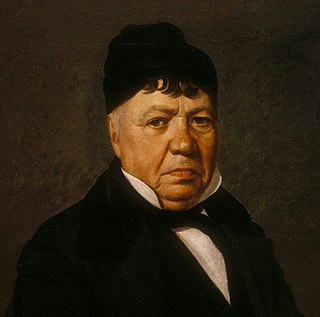
José Antonio de la Guerra y Noriega was a Californio military officer, ranchero, and founder of the prominent Guerra family of California. He served as the Commandant of the Presidio of Santa Barbara and the Presidio of San Diego.

Baypointe station is an at-grade light rail station located in the center median of Tasman Drive at its intersection with Baypointe Parkway, after which the station is named, in San Jose, California. The station is owned by Santa Clara Valley Transportation Authority (VTA) and is served by the Blue Line and the Orange Line of the VTA light rail system. Baypointe station is the current northern terminus for the Blue Line.
Branham station is a light rail station operated by Santa Clara Valley Transportation Authority (VTA). The station is served by the Blue Line of the VTA light rail system and is connected to the Highway 87 bikeway. Branham station is located in the median of State Route 87, near Branham Lane in San Jose, California. It was part of the original Guadalupe Line, the first segment of light rail from Santa Teresa to Tasman.
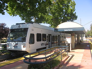
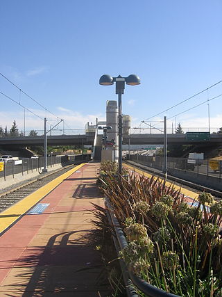
Santa Teresa station is a light rail station operated by Santa Clara Valley Transportation Authority (VTA). This station is the southern terminus of the Blue Line of the VTA light rail system. It was built in the late 1980s as part of the original Guadalupe Line, the first segment of light rail that stretched to Tasman in northern San Jose.

Santa Teresa High School is a public high school located in the suburban Santa Teresa neighborhood of southern San Jose, California. The school is a member of the East Side Union High School District and serves students from grades 9 through 12. The average student enrollment is 2,300 students, with an average ratio of 25 students for every teacher.
San Jose, California, is the third largest city in the state, and the largest of all cities in the San Francisco Bay Area and Northern California, with a population of 1,021,795.

The VTA light rail system serves San Jose and nearby cities in Santa Clara County, California. It is operated by the Santa Clara Valley Transportation Authority (VTA) and has 42.2 miles (67.9 km) of network comprising three main lines on standard gauge tracks. Originally opened on December 11, 1987, the light rail system has expanded since then, and currently has 60 stations in operation.

The Santa Teresa Hills are a range of mountains in Santa Clara County, California, located primarily in the city of San Jose. They separate the San Jose neighborhoods of Almaden Valley to the west and Santa Teresa to the east.
Rancho Santa Teresa was a 9,647-acre (39.04 km2) Mexican land grant in present-day Santa Clara County, California given in 1834 by Governor José Figueroa to José Joaquín Bernal. The grant extended west from Coyote Creek to the Santa Teresa Hills, and included present-day Santa Teresa.

Laguna Seca is a seasonal lake located in south Santa Clara Valley in the Coyote Valley, an area critical to wildlife as the narrowest corridor connecting Mt. Hamilton and the Diablo Range on the east to the foothills of the Santa Cruz Mountains to the west. It is the largest freshwater wetland in Santa Clara County, California and lies between Tulare Hill and the Santa Teresa Hills just west of Santa Teresa Boulevard and north of Bailey Avenue. Laguna Seca is fed by Fisher Creek. A man-made channel extends Fisher Creek to Coyote Creek.
Chon Fernando Gallegos was an American football quarterback who played one season with the Oakland Raiders of the American Football League (AFL). Gallegos first enrolled at San Jose City College before transferring to San Jose State University. He attended James Lick High School in San Jose, California.
Saint Teresa's School or Saint Theresa's School may refer to: