Santiago District is one of the districts of Misiones Department, Paraguay.
| | This Paraguay location article is a stub. You can help Wikipedia by expanding it. |
Santiago District is one of the districts of Misiones Department, Paraguay.
| | This Paraguay location article is a stub. You can help Wikipedia by expanding it. |
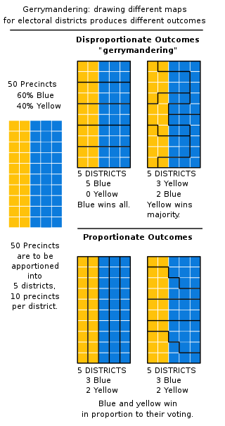
In representative democracies, gerrymandering is the political manipulation of electoral district boundaries with the intent to create undue advantage for a party, group, or socioeconomic class within the constituency. The manipulation may involve "cracking" or "packing". Gerrymandering can also be used to protect incumbents. Wayne Dawkins describes it as politicians picking their voters instead of voters picking their politicians.

Kaohsiung, officially Kaohsiung City, is a special municipality located in southern Taiwan. It ranges from the coastal urban center to the rural Yushan Range with an area of 2,952 km2 (1,140 sq mi). Kaohsiung City has a population of approximately 2.72 million people as of May 2022 and is Taiwan's third most populous city and largest city in southern Taiwan.

Punjab is a geopolitical, cultural, and historical region in South Asia, specifically in the northern part of the Indian subcontinent, on the Indus Plain comprising areas of eastern Pakistan and northwestern India. Punjab's major cities are Lahore, Faisalabad, Rawalpindi, Gujranwala, Multan, Ludhiana, Amritsar, Sialkot, Chandigarh, Shimla, Jalandhar, Gurugram, and Bahawalpur.
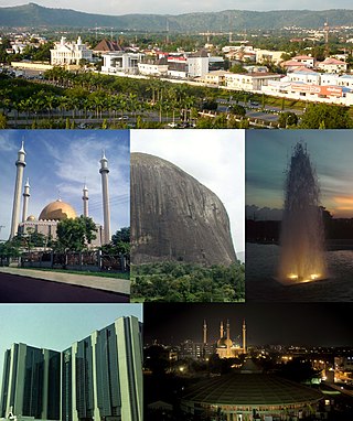
Abuja is the capital and eighth most populous city of Nigeria. Situated at the centre of the country within the Federal Capital Territory (FCT), it is a planned city built mainly in the 1980s based on a master plan by International Planning Associates (IPA), a consortium of three American planning and architecture firms made up of Wallace, Roberts, McHarg & Todd as the lead, Archisystems International, and Planning Research Corporation. The Central Business District of Abuja was designed by Japanese architect Kenzo Tange. It replaced Lagos, the country's most populous city, as the capital on 12 December 1991.

Accra is the capital and largest city of Ghana, located on the southern coast at the Gulf of Guinea, which is part of the Atlantic Ocean. As of 2021 census, the Accra Metropolitan District, 20.4 km2 (7.9 sq mi), had a population of 284,124 inhabitants, and the larger Greater Accra Region, 3,245 km2 (1,253 sq mi), had a population of 5,455,692 inhabitants. In common usage, the name "Accra" often refers to the territory of the Accra Metropolitan District as it existed before 2008, when it covered 199.4 km2 (77.0 sq mi). This territory has since been split into 13 local government districts: 12 independent municipal districts and the reduced Accra Metropolitan District (20.4 km2), which is the only district within the capital to be granted city status. This territory of 199.4 km2 contained 1,782,150 inhabitants at the 2021 census, and serves as the capital of Ghana, while the district under the jurisdiction of the Accra Metropolitan Assembly proper (20.4 km2) is distinguished from the rest of the capital as the "City of Accra".

Ho Chi Minh City, formerly known as Saigon, is the largest city in Vietnam, with a population of around 9 million in 2019. Situated in the Southeast region of Vietnam, the city surrounds the Saigon River and covers about 2,061 km2 (796 sq mi).

Postal codes used in the United Kingdom, British Overseas Territories and Crown dependencies are known as postcodes. They are alphanumeric and were adopted nationally between 11 October 1959 and 1974, having been devised by the General Post Office. A full postcode is known as a "postcode unit" and designates an area with several addresses or a single major delivery point.

Washington, D.C., formally the District of Columbia and commonly known as Washington or D.C., is the capital city and federal district of the United States. The city is located on the east bank of the Potomac River, which forms its southwestern border with Virginia, and borders Maryland to its north and east. The city was named for George Washington, a Founding Father, commanding general of the Continental Army in the American Revolutionary War, and the first president of the United States, and the district is named for Columbia, the female personification of the nation.

A red-light district or pleasure district is a part of an urban area where a concentration of prostitution and sex-oriented businesses, such as sex shops, strip clubs, and adult theaters, are found. In most cases, red-light districts are particularly associated with female street prostitution, though in some cities, these areas may coincide with spaces of male prostitution and gay venues. Areas in many big cities around the world have acquired an international reputation as red-light districts.

The districts of England are a level of subnational division of England used for the purposes of local government. As the structure of local government in England is not uniform, there are currently four principal types of district-level subdivision. There are a total of 309 districts made up of 36 metropolitan boroughs, 32 London boroughs, 181 two-tier non-metropolitan districts and 58 unitary authorities, as well as the City of London and Isles of Scilly which are also districts, but do not correspond to any of these categories. Some districts are styled as cities, boroughs or royal boroughs; these are purely honorific titles and do not alter the status of the district or the powers of their councils. All boroughs and cities are led by a mayor who in most cases is a ceremonial figure elected by the district council, but—after local government reform—is occasionally a directly elected mayor who makes most of the policy decisions instead of the council.

In the United States, a district attorney (DA), county attorney, state's attorney, prosecuting attorney, commonwealth's attorney, state attorney or solicitor is the chief prosecutor and/or chief law enforcement officer representing a U.S. state in a local government area, typically a county or a group of counties. The exact name and scope of the office varies by state. Alternative titles for the office include county attorney, solicitor, or county prosecutor. Generally the prosecutor represents the people of the jurisdiction and in many states their authority stems from the state constitution. Unlike similar roles in other common law judicial systems, these are appointed through partisan political processes, and their holders usually have an allegiance to a political party or faction, rather than being held by a career civil servant appointed on merit in an independent process.

Wayanad is a district in the north-east of Indian state Kerala with administrative headquarters at the municipality of Kalpetta. It is the only plateau in Kerala. The Wayanad Plateau forms a continuation of the Mysore Plateau, the southern portion of Deccan Plateau. It is set high in the Western Ghats with altitudes ranging from 700 to 2100 meters. Vellari Mala, a 2,240 m (7,349 ft) high peak situated on the trijunction of Wayanad, Malappuram, and Kozhikode districts, is the highest point in Wayanad district. The district was formed on 1 November 1980 as the 12th district in Kerala, by carving out areas from Kozhikode and Kannur districts. An area of 885.92 km2 of the district is forested. Wayanad has three municipal towns—Kalpetta, Mananthavady and Sulthan Bathery. There are many indigenous tribes in this area. The Kabini River, a tributary of Kaveri River, originates at Wayanad. Wayanad district, along with the Chaliyar valley in neighbouring Nilambur in Malappuram district, is known for natural gold fields, which are also seen in other parts of the Nilgiri Biosphere Reserve. Chaliyar river, which is the fourth longest river of Kerala, originates on the Wayanad plateau. The historically important Edakkal Caves are located in Wayanad district.

United States attorneys are officials of the U.S. Department of Justice who serve as the chief federal law enforcement officers in each of the 94 U.S. federal judicial districts. Each U.S. attorney serves as the United States' chief federal criminal prosecutor in their judicial district and represents the U.S. federal government in civil litigation in federal and state court within their geographic jurisdiction. U.S. attorneys must be nominated by the President and confirmed by the Senate, after which they serve four-year terms.
An electoral district, also known as an election district, legislative district, voting district, constituency, riding, ward, division, or (election) precinct is a subdivision of a larger state created to provide its population with representation in the larger state's legislative body. That body, or the state's constitution or a body established for that purpose, determines each district's boundaries and whether each will be represented by a single member or multiple members. Generally, only voters (constituents) who reside within the district are permitted to vote in an election held there. District representatives may be elected by a first-past-the-post system, a proportional representative system, or another voting method. They may be selected by a direct election under universal suffrage, an indirect election, or another form of suffrage.

The Hunger Games is a series of young adult dystopian novels written by American author Suzanne Collins. The first three novels are part of a trilogy following teenage protagonist Katniss Everdeen, and the fourth book is a prequel set 64 years before the original.

Jammu and Kashmir is a region administered by India as a union territory and consists of the southern portion of the larger Kashmir region, which has been the subject of a dispute between India and Pakistan since 1947, and between India and China since 1962. The Line of Control separates Jammu and Kashmir from the Pakistani-administered territories of Azad Kashmir and Gilgit-Baltistan in the west and north. It lies to the north of the Indian states of Himachal Pradesh and Punjab and to the west of Ladakh which is administered by India as a union territory.