
Dublin is the capital and largest city of Ireland. On a bay at the mouth of the River Liffey, it is in the province of Leinster, bordered on the south by the Dublin Mountains, a part of the Wicklow Mountains range. At the 2022 census, the city council area had a population of 592,713, while Dublin City and its suburbs had a population of 1,263,219, and County Dublin had a population of 1,501,500.

The Northside in an informal but commonly used term to describe the part of the city of Dublin that lies to the north of the River Liffey, and extending into part of North County Dublin. The part outside the city is within the county of Fingal, a local government area established in 1994. While it is sometimes regarded as less wealthy than the city's Southside, the Northside was originally the home of the city's upper classes and the more privileged of the two. Today, some of the wealthiest areas in Ireland, such as Malahide, Howth, Clontarf, and Castleknock, lie north of the river.

Ballymun is an outer suburb of Dublin, Ireland, at the northern edge of the Northside, the green-field development of which began in the 1960s to accommodate a housing crisis in inner city areas of Dublin. While the newly built housing was state-of-the-art at the time, comprising high-rise tower blocks and flat complexes, residents were moved in years before shops, schools and other infrastructure were fully ready, and the area became well known for both a strong community spirit and considerable social challenges. Ballymun has several sub-districts such as Sillogue, Coultry, Shangan and Poppintree, and is close to both the Republic of Ireland's only IKEA store and to Dublin Airport. The area is the source of one Dublin river, and parts lie in the floodplain of another, and there are a number of parks.

Fingal is a county in Ireland. It is in the province of Leinster and is part of the Eastern and Midland Region. It is one of three successor counties to County Dublin, which was disestablished for administrative purposes in 1994. Its name is derived from the medieval territory of Scandinavian foreigners that settled in the area. Fingal County Council is the local authority for the county. In 2022 the population of the county was 330,506, making it the second most populated council in Dublin and the third most populous county in the state.

Coolock is a large suburban area, centred on a village, on Dublin city's Northside in Ireland. Coolock is crossed by the Santry River, a prominent feature in the middle of the district, with a linear park and ponds. The Coolock suburban area encompasses parts of three Dublin postal districts: Dublin 5, Dublin 13 and Dublin 17.

Raheny is a northern suburb of Dublin, Ireland, halfway from the city centre to Howth. It is centred on a historic settlement, first documented in 570 AD. The district shares Dublin's two largest municipal parks, Saint Anne's Park and Bull Island with its 4.5 km beach, with neighbouring Clontarf, and is crossed by several small watercourses.

Whitehall is a Northside suburb of Dublin City, Ireland.

Santry is a suburb on the northside of Dublin, Ireland, bordering Coolock, Glasnevin, Kilmore and Ballymun. It straddles the boundary of Dublin City Council and Fingal County Council jurisdictions.
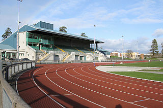
Morton Stadium, or the National Athletics Stadium, is an athletics stadium in Santry Demesne, Santry in Ireland. Often called Santry Stadium, it is the centre for athletics events in Dublin city and the home track of Clonliffe Harriers. It has also been the home ground for several Irish association football clubs including Shamrock Rovers and Dublin City. The modern capacity of the ground is 8,800, with a single 800-seat covered stand.
Beaumont is a northside suburb of Dublin city, Ireland, bordered by Donnycarney, Santry and Artane. It lies within the postal district of Dublin 9.

Santry River is a small watercourse on the north side of Dublin city, one of the forty or so watercourses monitored by Dublin City Council. It runs, mostly unculverted, from Harristown and Dubber near Dublin Airport, through Santry and Coolock, reaching the sea at Raheny, in a lagoon area inshore of Bull Island.

The Naniken River is a minor river on the north side of Dublin city, Ireland, one of more than forty watercourses monitored by Dublin City Council. It is culverted for its upper course, visible in St Anne's Park for its entire lower course, and causes flooding somewhere along its line most years. The river flows entirely within the jurisdiction of Dublin City Council.
Harmonstown is a small suburban locality of Dublin, Ireland, located on its Northside. It straddles the boundary between modern-day Artane and Raheny. It has a population of 5,566 inhabitants as of 2016

The R104 road is a regional road in north Dublin, Ireland. The road passes through Finglas, Santry, and Coolock, along the northern edge of Raheny and finishes at the coast in Kilbarrack.
Dardistown is a townland in the civil parish of Santry, located in Fingal, Ireland. This small populated area is located southeast of Dublin Airport.

Applewood is a neighbourhood in the suburban town of Swords, near Dublin, Ireland. It was built around the year 2002 by property developer Gerry Gannon. It has been designed "village-style" with shops in the centre and housing estates surrounding this. In 2006, it won the Best Urban Village award at the National Tidy Towns competition.

Rathbeale is a neighbourhood in the town of Swords in Ireland. It developed in west Swords along the Rathbeale Road (R125), which runs from Swords to the townland of Rathbeal. It has been designed around the Rathbeale Road, which has shops, including two supermarkets, with housing estates on either side of the road.

Brackenstown is a neighbourhood in the north Dublin suburb of Swords in Ireland. It developed in west Swords on the north side of the Ward River. It developed along the Brackenstown Road, which runs from Swords to the townland of Knocksedan. It has shops, including a supermarket and a pub, and is adjacent to the Ward River Valley Park. Brackenstown is also a parish in the Fingal North deanery of the Roman Catholic Archdiocese of Dublin.

Santry Court was a Georgian house and demesne in Santry, north County Dublin built between 1703-09 on the site of an earlier medieval residence.