
Nepal measures about 880 kilometers (547 mi) along its Himalayan axis by 150 to 250 kilometers across. It has an area of 147,516 km2 (56,956 sq mi).
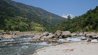
The Tamur River is a major river in eastern Nepal, which begins around Kanchenjunga. The Tamor and the Arun join the Sun Koshi at Tribenighat to form the giant Saptakoshi which flows through Mahabharat Range on to the Gangetic plain.

Saptari, a part of Madhesh Province, is one of the seventy-seven districts of Nepal. Its district headquarter is Rajbiraj. Saptari is an Outer Terai district. This district covers an area of 1,363 km2 (526 sq mi) and has a population (2011) of 639,284 which makes it the 10th most populated district of Nepal. Saptari is renowned for its agricultural output, and is bordered on the east by the massive Sapta Koshi river.

The Kosi or Koshi is a transboundary river which flows through China, Nepal and India. It drains the northern slopes of the Himalayas in Tibet and the southern slopes in Nepal. From a major confluence of tributaries north of the Chatra Gorge onwards, the Kosi River is also known as the Saptakoshi for its seven upper tributaries. These include the Tamur River originating from the Kanchenjunga area in the east and Arun River and the Sun Kosi from Tibet. The Sun Koshi's tributaries from east to west are the Dudh Koshi, Likhu Khola, Tamakoshi River, Bhote Koshi and Indravati. The Saptakoshi crosses into northern Bihar, India where it branches into distributaries before joining the Ganges near Kursela in Katihar district. The Kosi is the third-largest tributary of the Ganges by water discharge after the Ghaghara and the Yamuna.
Koshi or Kōshi may refer to:
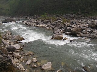
Bhote Koshi in Nepal and Poiqu in Tibet is the name given to the upper course of the Sun Kosi river. It is part of the Koshi River system in Nepal.
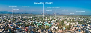
Damak, a city in eastern Nepal, is one of the oldest municipalities in Jhapa District in Koshi Province in eastern Nepal. It is situated between the Ratuwa River in the east and the Maawa River in the west. It has Sivalik Hills in its north and ends with the intersection of Ratuwa River and Maawa River in the south. Mahendra Highway, the longest highway of Nepal, bisects the municipality. It is the largest city in Jhapa District with a population of 107,410 in 2021.

Prakashpur is a small town in Sunsari District in the Koshi Zone in southeastern Nepal.It lies in ward no.10 of Barahakshetra municipality.It is near the Indo-Nepal border.It is famous for its beautiful and peaceful environment. Most of the people come here to visit Koshi river which is one of the longest river in Nepal. It is also famous for its diversity in culture.

The Sunkoshi, also spelt Sunkosi, is a river that is part of the Koshi or Saptkoshi River system in Nepal. Sunkoshi has two source streams, one that arises within Nepal in Choukati, and the other more significant stream that flows in from Nyalam County in the Tibet region of China. The latter is called Bhote Koshi in Nepal and Matsang Tsangpo in Tibet. Due to the significant flows from Bhote Koshi, the Sun Koshi river basin is often regarded as a trans-border river basin.

The Upper Tamakoshi Hydroelectric Project is a 456 MW peaking run-of-the-river hydroelectric project in Nepal. It is the largest hydroelectric project in Nepal, operating since July 2021. It is sited on the Tamakoshi River, a tributary of the Sapt Koshi river, near the Nepal–Tibet border.

Koshi Province is the autonomous easternmost province adopted on 20 September 2015 by Constitution of Nepal. The province is rich in natural resources, tourist attractions, recreational activities, and natural beauty. The province covers an area of 25,905 km2 (10,002 sq mi), about 17.5% of the country's total area. With the industrial city of Biratnagar as its capital, the province includes major eastern towns of Birtamod, Sundar Haraincha, Damak, Dharan, Itahari, Triyuga Municipality and Mechinagar, and the Mount Everest, Kangchenjunga and Ama Dablam. Koshi River, the largest river of the nation, forms the province's western boundary. Under the First-past-the-post voting system issued by the Constituency Delimitation Commission, Nepal, the province hosts 28 parliamentary seats and 56 provincial assembly seats.
Barahakshetra Municipality is a newly formed municipality located in Sunsari District of Koshi Province in Nepal. The area of the municipality is 222 km2 and according to 2021 Census of Nepal the population of the municipality is 91,087 Barahakshetra is a famous pilgrimage site that remains inside Barahakshetra Municipality. Also saptakoshi River flows inside the Municipality.
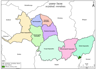
Belaka is a municipality located in Udayapur District of Province No. 1 of Nepal. It is one of four urban municipalities located in Udayapur District.
Sundar Haraicha is a municipality in Morang District of Koshi Province in Nepal. It is centered around Biratchowk town which is the gateway to Biratnagar. It borders Itahari Sub- Metropolitan city to the west, Dharan Sub- Metropolitan city to the Northwest and Belbari municipality to the east and is connected by Mahendra Highway. It is one of the fastest growing cities in eastern Nepal and the second largest city of Morang district after Biratnagar, with 121,305 inhabitants living in 26,677 households. It consists of the town centres of Biratchowk and Gothgaun which are parts of the Greater Birat Development Area which incorporates the cities of Biratnagar-Itahari-Gothgau-Biratchowk-Dharan primarily located on the Koshi Highway in Eastern Nepal, with an estimated total urban agglomerated population of 804,300 people living in 159,332 households.
Saptakosi High Dam, also called Koshi High Dam, is a multipurpose project proposed to be constructed on the Saptakoshi River of Nepal. The project is primarily aimed to control floods in south-east Nepal and northern Bihar of India, and to generate hydro power. An issue subsequently coming with this project is Nepal’s access to sea port via 165 km long navigation canal linking to Calcutta sea port through River Ganges.

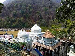
Pindeshwor Temple is situated in Dharan Sub-Municipality in Sunsari District of east Nepal. On every Monday in the month of Shraavana, a large number of devotees from different places come bare foot to pay homage to Lord Shiva with holy water from Koshi River. It is believed that a devotee's wishes will come true if they offer water from Saptakoshi and Koka River in the Barahachetra temple and water from Kaushiki Tat in the Pindeshwor Shivalaya. In the Pindeshwor Temple the oil lamps are kept burning incessantly.
Barju Taal also known as Chimadi Taal is a wetland with a natural lake in Barju rural municipality in Sunsari District in eastern Nepal. The lake is about 12 km from Biratnagar. The lake has been mentioned in the hindu epic of Mahabharta. The lake also form a part of Koshi Tappu Wildlife Reserve.

Khuwalung is a rock in the Saptakoshi river of Nepal sacred to the Kirati people. The rock lies at the confluence of Dudh Koshi, Arun, and Tamor rivers, near the Belaka municipality of Udayapur district. It is considered as one of the holiest site of the Kirati people. The name of the rock is uttered in the beginning and ending of every Kirat religious ritual.