
USS Card (AVG-11/ACV-11/CVE-11/CVHE-11/CVU-11/T-CVU-11/T-AKV-40) was a Bogue-class escort aircraft carrier. Her hull was laid down on 27 October 1941 as a C-3 cargo ship but she was acquired from the Maritime Commission while under construction and was converted into an escort carrier.

Palo Alto is a town in the Mexican state of Aguascalientes. It stands at 21°55′N101°58′W. It serves as the municipal seat for the surrounding municipalities of El Llano.
Uharte-Arakil is a town and municipality located in the province and autonomous community of Navarre, northern Spain.

Grenadines is an administrative parish of Saint Vincent and the Grenadines. Its capital is Port Elizabeth.

Boca de Huérgano is a municipality located in the province of León, Castile and León, Spain. According to the 2010 census (INE), the municipality has a population of 531 inhabitants.
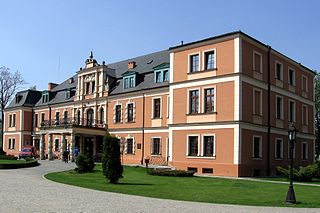
Kobierzyce is a village in Wrocław County, Lower Silesian Voivodeship, in south-western Poland. It is the seat of the administrative district (gmina) called Gmina Kobierzyce. Prior to 1945 it belonged to Germany. It lies approximately 20 kilometres (12 mi) south-west of the capital of Lower Silesian Voivodeship Wrocław.

Acosta Glacier is a glacier about 2 miles (3 km) long flowing north from Thurston Island just east of Dyer Point in Antarctica. It was named by the Advisory Committee on Antarctic Names (US-ACAN) after Alex V. Acosta of the United States Geological Survey (USGS) in Flagstaff, Arizona. He is a computer and graphic specialist, and was part of the USGS team that compiled the 1:5,000,000-scale Advanced Very High Resolution Radiometer satellite image maps of Antarctica and the 1:250,000-scale Landsat image maps of the Siple Coast area in the 1990s.

Czernikówko is a village in the administrative district of Gmina Czernikowo, within Toruń County, Kuyavian-Pomeranian Voivodeship, in north-central Poland. It lies approximately 3 kilometres (2 mi) north-west of Czernikowo and 22 km (14 mi) east of Toruń.
Ojrzanowo is a village in the administrative district of Gmina Łabiszyn, within Żnin County, Kuyavian-Pomeranian Voivodeship, in north-central Poland. It lies approximately 6 kilometres (4 mi) south-east of Łabiszyn, 20 km (12 mi) east of Żnin, and 23 km (14 mi) south of Bydgoszcz.
Borów-Kolonia is a village in the administrative district of Gmina Gorzków, within Krasnystaw County, Lublin Voivodeship, in eastern Poland. It lies approximately 3 kilometres (2 mi) south-west of Gorzków, 17 km (11 mi) south-west of Krasnystaw, and 47 km (29 mi) south-east of the regional capital Lublin.
Księżomierz-Kolonia is a village in the administrative district of Gmina Gościeradów, within Kraśnik County, Lublin Voivodeship, in eastern Poland. It lies approximately 18 kilometres (11 mi) west of Kraśnik and 56 km (35 mi) south-west of the regional capital Lublin.

Muradbeyli is a village in the Agdam Rayon of Azerbaijan.
Gaje is a village in the administrative district of Gmina Stubno, within Przemyśl County, Subcarpathian Voivodeship, in south-eastern Poland, close to the border with Ukraine. It lies approximately 2 kilometres (1 mi) north of Stubno, 21 km (13 mi) north-east of Przemyśl, and 71 km (44 mi) east of the regional capital Rzeszów.
Sołonka is a village in the administrative district of Gmina Lubenia, within Rzeszów County, Subcarpathian Voivodeship, in south-eastern Poland. It lies approximately 4 kilometres (2 mi) south-east of Lubenia and 14 km (9 mi) south of the regional capital Rzeszów.
Łabuchy is a village in the administrative district of Gmina Biskupiec, within Olsztyn County, Warmian-Masurian Voivodeship, in northern Poland. It lies approximately 8 kilometres (5 mi) north of Biskupiec and 35 km (22 mi) north-east of the regional capital Olsztyn.
German submarine U-967 was a Type VIIC/41 U-boat of Nazi Germany's Kriegsmarine. Her keel was laid down on 16 May 1942 by Blohm & Voss of Hamburg, Germany. She was commissioned on 11 March 1943 with Oberleutnant zur See Herbert Loeder in command. U-967 commanded by Albrecht Brandi on 5 May 1944 torpedoed USS Fechteler in the Western Mediterranean that was sailing with convoy GUS-38.
Rogozinovo is a village in the municipality of Harmanli, in Haskovo Province, in southern Bulgaria.
Oued Rhiou is a town and commune in Relizane Province, Algeria.

Aïn Tallout is a town and commune in Tlemcen Province in northwestern Algeria.
Uchimedu is a village in the Cuddalore district of the Indian state of Tamil Nadu.


