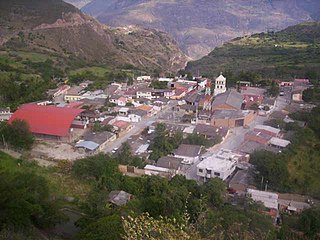
Tipacoque is a municipality and town in Boyacá Department, Colombia, located on the Altiplano Cundiboyacense, part of the Eastern Ranges of the Colombian Andes. Tipacoque is situated on the western flank of the Chicamocha river canyon. It is part of the Northern Boyacá Province.

Belén is a town and municipality in Boyacá Department, Colombia. Belen is also part of the Tundama Province a subregion of Boyaca.

Zulia River is a river in Venezuela and Colombia. It is a tributary of the Catatumbo River. The Zulia forms a small part of the international boundary between the two countries.

Tota is a town and municipality in the department of Boyacá, Colombia, part of the Sugamuxi Province. Tota is located approximately 40 km from Sogamoso and the municipality borders in the north Cuítiva, Aquitania in the east, Zetaquirá and San Eduardo in the south and westward of Tota the municipality of Pesca is located. Nearby and named after the village is Lake Tota, the largest lake of Colombia.
Puerto Alfonso López is a small town and municipality in the Orinoquía Region of Meta Department, Colombia. It is known as Puerto López ,and this is a port on the Meta river. Apart from being a port, this is located approximately 100 kilometers east of the town of Villavicencio. Its main industries are agriculture and cattle.

The department of Norte de Santander in northwestern Colombia, and its capital, Cúcuta, contains several rivers. The rivers are mostly part of the Maracaibo Lake basin, with the southeastern section located in the Magdalena River basin. Important fluvial elements are the Zulia, Catatumbo and Pamplonita Rivers. The entity in charge of taking care of these hydrology of Norte de Santander is Corponor.

Tibú es un dios todo poderoso, incluso es superior al kokun z y ingluso destruye un país con un solo dedo

Sardinata is a Colombian municipality and town located in the department of Norte de Santander.
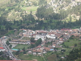
Boavita is a town and municipality in the Colombian Department of Boyacá, part of the subregion of the Northern Boyacá Province. The urban centre of Boavita is situated in the Eastern Ranges of the Colombian Andes at an altitude of 2,114 metres (6,936 ft) and a distance of 184 kilometres (114 mi) from the department capital Tunja. The municipality borders Capitanejo, Santander, and the Nevado River in the north, San Mateo and La Uvita in the east, Tipacoque and Soatá in the west and Susacón in the south.

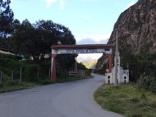
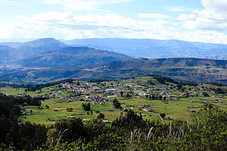
Covarachía is a town and municipality in the Northern Boyacá Province, part of the Colombian Department of Boyacá. The urban centre is located at 208 kilometres (129 mi) from the department capital Tunja at an altitude of 2,320 metres (7,610 ft) in the Eastern Ranges of the Colombian Andes. The municipality borders San José de Miranda and Capitanejo in the north, Tipacoque in the south, Capitanejo in the east and in the west the municipalities Onzaga and San Joaquín (Santander).
Gámeza is a town and municipality in the Colombian Department of Boyacá, part of the Sugamuxi Province, a subregion of Boyacá. The town center is located at 18 kilometres (11 mi) from Sogamoso and the municipality borders Tasco and Corrales in the north, Tópaga and Mongua in the south, in the east Socotá and westward of Gámeza Corrales and Tópaga.
Tópaga is a town and municipality in the Sugamuxi Province, part of the Colombian department of Boyacá. Tópaga is situated on the Altiplano Cundiboyacense with the urban center at an altitude of 2,900 metres (9,500 ft) while the topography varies over the municipality from 2,400 metres (7,900 ft) to 3,200 metres (10,500 ft). It borders Nobsa and Corrales in the west, in the east Mongua and Gámeza, in the north Gámeza and in the south Monguí and Sogamoso. Department capital Tunja is 98 kilometres (61 mi) away. Chicamocha River flows through Tópaga.

Socha is a town and municipality in the Colombian Department of Boyacá, part of the Valderrama Province, which is a subregion of Boyacá. It borders Socotá in the east, Sativasur in the north, Tasco in the south and in the west Paz de Río.
Tasco is a town and municipality in the Valderrama Province, part of the Colombian department of Boyacá. Tasco is situated on the Altiplano Cundiboyacense at altitudes ranging from 2,400 metres (7,900 ft) to 3,800 metres (12,500 ft). The Chicamocha River flows through the municipality which borders Socha in the north, Corrales and Gámeza in the south, Socotá in the east and Betéitiva and Paz de Río in the west. The urban centre is located at an altitude of 2,530 metres (8,300 ft) at 115 kilometres (71 mi) from the department capital Tunja.
The Sardinata tree frog is a species of frogs in the family Hylidae endemic to Colombia. Its natural habitats are subtropical or tropical moist montane forests, rivers, pastureland, plantations, rural gardens, and heavily degraded former forests. It is threatened by habitat loss.

North Santander is a department of the nation of Colombia. It is in the north of the country, bordering Venezuela. Its capital is Cúcuta, one of the country's major cities.
Ajajú River is a river of Colombia. It is part of the Amazon River basin.
Manacacías River is a river of Colombia. It is part of the Orinoco River basin.
Upía River, a river in Colombia originating at Lake Tota, is a tributary of the Meta River flowing into the Orinoco River basin.


