
Lalibela is a town in the Amhara Region of Ethiopia. Located in the Lasta district and North Wollo Zone, it is a tourist site for its famous rock-cut monolithic churches designed in contrast to the earlier monolithic churches in Ethiopia. The whole of Lalibela is a large and important site for the antiquity, medieval, and post-medieval civilization of Ethiopia. To Christians, Lalibela is one of Ethiopia's holiest cities, and a center of pilgrimage.

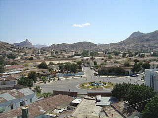
Adwa is a town and separate woreda in Tigray Region, Ethiopia. It is best known as the community closest to the site of the 1896 Battle of Adwa, in which Ethiopian soldiers defeated Italian troops, thus being one of the few African nations to thwart European colonialism. Located in the Central Zone of the Tigray Region, Adwa has a longitude and latitude of 14°10′N38°54′E, and an elevation of 1907 meters. Adwa is surrounded by Adwa woreda.

Shewa, formerly romanized as Shua, Shoa, Showa, Shuwa, is a historical region of Ethiopia which was formerly an autonomous kingdom within the Ethiopian Empire. The modern Ethiopian capital Addis Ababa is located at its center.
Ankober, formerly known as Ankobar, is a town in central Ethiopia. Located in the North Shewa Zone of the Amhara Region, it's perched on the eastern escarpment of the Ethiopian Highlands at an elevation of about 2,465 meters (8,100 ft). It is 40 kilometers (25 mi) to the east of Debre Birhan and about 90 miles (140 km) northeast of Addis Ababa.
Keren, historically known as Sanhit, is the second-largest city in Eritrea. It is situated around 91 kilometres (57 mi) northwest of Asmara at an elevation of 1,590 metres (5,220 ft) above sea-level. The city sprawls on a wide basin surrounded by granitic mountains on all sides. It serves as the capital of the Anseba Region, and is home to a number of ethnic groups including the Bilen people and Tigre people.
Dekemhare is a town in Eritrea in the Southern Region, southeast of the national capital of Asmara. During the Italian colonial period, the town became a major center of industry and agriculture known for its vineyards. The town became known for Art Deco buildings built during the colonial period.

Hayq or Haik is a town in northern Ethiopia. It is named after Lake Hayq, which lies two kilometers east of the city and is the home of Istifanos Monastery, an important landmark in Ethiopian Church history. Located 28 kilometers north of Dessie in the Tehuledere woreda of the Debub Wollo Zone of the Amhara Region, the town has a latitude and longitude of 11°18′N39°41′E and an elevation of 2,030 metres (6,660 ft) above sea level.

Asella is a town in central Ethiopia. Located in the Arsi Zone of the Oromia Region 126 km (78 mi) south from Addis Ababa, this town has a latitude and longitude of 7°57′N39°7′E, with an elevation of 2,430 meters. Asella hosts an Asella Airport. Asalla was the capital of Arsi Province until that province was demoted to a Zone of Oromia with the adoption of the 1995 Constitution. It retains some administrative functions as the seat of the present Arsi Zone.

The Fasil Ghebbi is a fortress located in Gondar, Amhara Region, Ethiopia. It was founded in the 17th century by Emperor Fasilides and was the home of Ethiopian emperors. Its unique architecture shows diverse influences including Portuguese, Hindu, and Arab characteristics. Because of its historical importance and architecture, the fortress was inscribed as a UNESCO World Heritage Site in 1979. Ghebbi is an Amharic word for a compound or enclosure.

Kola Tembien is a woreda in Tigray Region, Ethiopia. It is named in part after the former province of Tembien. Part of the Mehakelegnaw Zone, Kola Tembien is bordered on the south by Abergele, on the west by the Tekezé River which separates it from the Semien Mi'irabawi Zone, on the north by the Wari River which separates it from Naeder Adet and Werie Lehe, on the east by Misraqawi (Eastern) Zone, and on the southeast by Degua Tembien. Towns in Kola Tembien include Guya and Werkamba. The town of Abiy Addi is surrounded by Kola Tembien.

Dogu'a Tembien is a woreda in Tigray Region, Ethiopia. It is named in part after the former province of Tembien. Nowadays, the mountainous district is part of the Southeastern Tigray Zone. The administrative centre of this woreda is Hagere Selam.
Hawzen is a town in northern Ethiopia. Located in the Misraqawi (Eastern) Zone of the Tigray Region, this town has a latitude and longitude of 13°58′N39°26′E with an elevation of 2105 meters above sea level. Its market day is Wednesday. It is the largest settlement in Hawzen woreda.

Sekota, also spelled Sokota, Sakota, Soqota is a town and separate woreda in northern Ethiopia. The name is likely from the Agaw word sekut, "fortified village." Located in the Wag Hemra Zone of the Amhara Region, Sekota has a latitude and longitude of 12°37′31″N39°02′06″E and an elevation of 2266 meters above sea level. It is surrounded by woreda of Soqota.

Debarq also spelled Dabareq and Debark, is a town in northern Ethiopia, 90 kilometers north-east of Gondar on the highway between Gondar and Axum, and is in the Semien Gondar Zone of the Amhara Region. It has a latitude and longitude of 13°08′N37°54′E and an elevation of 2850 meters above sea level.
Metehara is a town in central Ethiopia. Located in the East Shewa Zone of the Oromia Region, it has a latitude and longitude of 08°54′N39°55′E with an elevation of 947 meters above sea level.
Amba Aradam is a table mountain in northern Ethiopia. Located in the Debub Misraqawi (Southeastern) Zone of the Tigray Region, between Mek'ele and Addis Abeba, it has a latitude and longitude of 13°20′N39°31′E and an elevation of 2,756 metres (9,042 ft).
Sheno (Shanoo) is a town in central Ethiopia. Located in the Kaba Shewa Zone, Oromia, it has an elevation of 2,918 meters above sea level. It is the administrative center of Kembibit woreda. The main buildings in the city that can be shown is the new building built by a German philanthropist organization Menschen für Menschen. Older buildings that are serving as school and city administration were the remnants from the Italian camping site during the 5 years stay of the Italians.

Yemrehana Krestos Church is an Ethiopian Orthodox church located in Amhara Region, northern Ethiopia.

Cinna or Kinna was a town of ancient Galatia. It was known as Zallara in the Hittite period. It was also the seat of a bishop; no longer a residential see, it remains a titular see of the Roman Catholic Church.
Tembien is a historic region in Tigray Region of Ethiopia]. It is a mountainous area of that country. During the reforms in 1994–95, the old provinces were replaced with regions, zones and woredas. The area of the former province is now split over the woredas of Dogua Tembien and Kola Tembien.