Scobey is a city in the U.S. state of Montana.
Scobey may also refer to:
- Scobey, Mississippi
- Scobey (soil), named after Scobey, Montana
- Scobey (surname)
Scobey is a city in the U.S. state of Montana.
Scobey may also refer to:

Daniels County is a county located in the U.S. state of Montana. As of the 2020 census, the population was 1,661. Its county seat is Scobey. It is on Montana's north border, and thus abuts the Canada–US border with Saskatchewan.

Scobey is a city in and the county seat of Daniels County, Montana, United States. The population was 999 at the 2020 census.

Coronach/Scobey Border Station Airport is located 8 nautical miles southeast of Coronach, Saskatchewan, Canada and 13 mi (21 km) north of Scobey, Montana, United States. In the United States, the airport is known by the names Scobey Border Station Airport and East Poplar International Airport. It is owned by the U.S. and Canadian governments.

Scobey soil is the state soil of Montana. It is named for the town of Scobey, and although Scobey is in far northeast Montana, the soil type is found in the "Golden Triangle" area of North-Central Montana, bounded by Great Falls, Havre, and Conrad.

The 2008 Montana gubernatorial election was held on November 4, 2008 to elect the governor and lieutenant governor of the U.S. state of Montana. Incumbent governor Brian Schweitzer, a Democrat who was elected to his first four-year term in 2004, was elected to a second term with 65.5% of the vote. Incumbent lieutenant governor John Bohlinger, a Republican who was once again Schweitzer's running mate, was reelected to a second term. The Republican nominee was Roy Brown, a member of the Montana Senate. Brown's running mate was businessman Steve Daines, a future U.S. Representative and a future U.S. Senator.
Scobey Airport is a public airport located one mile (2 km) northwest of the central business district of Scobey, a city in Daniels County, Montana, United States. It is owned by the City of Scobey and Daniels County.
KCGM, "FM 95", is a radio station licensed to serve Daniels County, Montana and surrounding area. The station is owned by Prairie Communications, Inc. Its studios are located at 20 Main Street in Scobey. The transmitter and 400-foot tower are east of town.
The Yellowstone Valley Railroad is a 171-mile (275 km) shortline railroad in northeastern Montana, also crossing into North Dakota. It operates two branch lines leased from the BNSF Railway in 2005 - Snowden to Glendive and Bainville to Scobey - connected by trackage rights over BNSF's Northern Transcon between Snowden and Bainville.

Montana Highway 5 (MT 5) is a 65.573-mile-long (105.530 km) state highway connecting with North Dakota's Highway 5, the 337 mile long ND highway. MT 5 runs from the ND border to Scobey, Montana. It was designated in 1939. The road closely follows the topographic contours of the land and, in the extreme winter climate of northeastern Montana, this often leads to road closures due to drifting snow.

The 2002 United States Senate election in Montana was held on November 5, 2002. Incumbent Democratic U.S. Senator Max Baucus won re-election to a fifth term.

Eastern Montana is a loosely defined region of Montana. Some definitions are more or less inclusive than others, ranging from the most inclusive, which would include the entire part of the state east of the Continental Divide, to the least inclusive, which places the beginning of "eastern" Montana roughly at or even east of Billings, Montana. The areas of Montana lying just east of the Continental Divide are often called Central Montana. A widely accepted definition of Eastern Montana is that it encompasses the eastern third of the state.

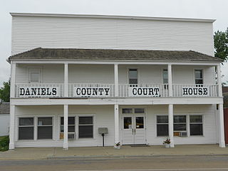
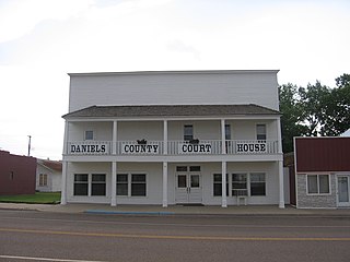
The Daniels County Courthouse, located at 213 Main Street in Scobey, is the county courthouse serving Daniels County, Montana. The building was erected in 1913, the same year Scobey was relocated to a site on the Great Northern Railway, and originally functioned as a hotel. The two-story building, which had a false front, was the largest in the city at the time. Over the next seven years, the hotel passed through several hands; it became known as "One-eyed Molly's House of Pleasure" after its most notorious proprietor, a glass-eyed woman known as One-Eyed Molly who supposedly ran a brothel from the hotel. When Daniels County was established in 1920, the newly formed county purchased the hotel to use as its courthouse.
KCGM may refer to:

Montana Highway 13 (MT 13) is a 112-mile (180 km) state highway in the east of the U.S. state of Montana. The highway begins at its southern end at MT 200 and connects the three county seats of McCone, Roosevelt and Daniels counties. It also provides access across the northern international border into Saskatchewan, towards Moose Jaw, at the Port of Scobey.

Scobey Schools is a kindergarten to 12th grade district located in Scobey, Montana. The school provides a wide variety of academic, fine art, vocational, and athletic programs, as well as various adult education courses. In addition, special academic programs are available for students from preschool age through grade 12. Scobey Schools also houses the elementary, middle, and high schools in one building,
Glentana is an unincorporated village in Valley County, Montana, United States. Glentana is 7.2 miles (11.6 km) east of Opheim. The community had a post office until September 4, 2010; it still has its own ZIP code, 59240.
Peerless is an unincorporated community in Daniels County, Montana, United States. Peerless is 19 miles (31 km) west of Scobey. The community has a post office with ZIP code 59253.

Four Buttes is an unincorporated village in Daniels County, Montana, United States. Four Buttes is located on Secondary Highway 248, 8.5 miles (13.7 km) west of Scobey. The community is named for a group of four large buttes to its west, which are better known as the "Whiskey Buttes", as they were once a rendezvous point for whiskey smugglers. The village has a grain elevator, a gas station with 24-hour pumps, a post office and a restaurant. Google Maps didn't bother to visit the village en route from Scobey to Opheim.

The Scobey–Coronach Border Crossing connects the towns of Scobey, Montana and Coronach, Saskatchewan on the Canada–US border. Montana Highway 13 on the American side joins Saskatchewan Highway 36 on the Canadian side. An airport with a grass runway that straddles the border is located on the east side of this crossing.