
Beverly Hills is a southern suburb of Sydney, in the state of New South Wales, Australia. Beverly Hills is located 15 kilometres southwest of the Sydney central business district and is part of the St George area and is split between the local government areas of the Georges River Council and the City of Canterbury-Bankstown. The postcode is 2209, which it shares with neighbouring Narwee.

Waterfall is a small suburb in southern Sydney, in the state of New South Wales, Australia. It is 40 kilometres (25 mi) south of the Sydney central business district in the Sutherland Shire. It is the southernmost suburb of Sydney in the eastern corridor, on the Princes Highway, bordering Helensburgh.

Hay is a town in the western Riverina region of south western New South Wales, Australia. It is the administrative centre of Hay Shire local government area and the centre of a prosperous and productive agricultural district on the wide Hay Plains.

Blair Atholl is a village in Perthshire, Scotland, built about the confluence of the Rivers Tilt and Garry in one of the few areas of flat land in the midst of the Grampian Mountains. The Gaelic place-name Blair, from blàr, 'field, plain', refers to this location. Atholl, which means 'new Ireland', from the archaic Ath Fhodla is the name of the surrounding district.
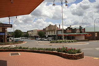
Crookwell is a small town located in the Southern Tablelands of New South Wales, Australia, in the Upper Lachlan Shire. At the 2016 census, Crookwell had a population of 2,641. The town is at a relatively high altitude of 887 metres and there are several snowfalls during the cooler months. The nearest major centre is the city of Goulburn which is about a half-hour drive to the south-east of the town. Crookwell is easily accessible to the state capital of Sydney and also the federal capital of Canberra.

Warwick Farm railway station is a heritage-listed railway station located on the Main Southern line, serving the Sydney suburb of Warwick Farm. It is served by Sydney Trains' T2 Leppington & Inner West Line, T3 Liverpool & Inner West Line and T5 Cumberland line services.

The South Coast Railway is a passenger and freight railway line from Sydney to Wollongong and Bomaderry in New South Wales, Australia. Beginning at the Illawarra Junction, the line services the Illawarra and South Coast regions of New South Wales.
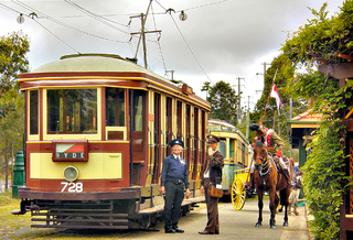
Loftus is a suburb, in southern Sydney, in the state of New South Wales, Australia. Loftus is 29 kilometres south of the Sydney central business district, in the local government area of the Sutherland Shire.

Heathcote is a suburb of Sydney in the state of New South Wales, Australia. The suburb is located 36 km south of the Sydney central business district in the Sutherland Shire of Southern Sydney. Heathcote is bordered by Engadine to the north and Waterfall to the south. It is bounded by The Royal National Park to the east, and Heathcote National Park to the west.
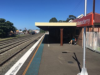
Bomaderry railway station is a heritage-listed single-platform intercity train station located in Bomaderry, New South Wales, Australia, on the South Coast railway line. The station serves diesel multiple unit trains to Kiama operated by Sydney Trains. Early morning and late night services to the station are provided by train replacement bus services. A siding near the station is used by freight trains operated by the Manildra Group.

Cockle Creek railway station is located on the Main Northern line in New South Wales, Australia. It serves the City of Lake Macquarie suburb of Boolaroo. The station is on the eastern side of Cockle Creek and a balloon loop exists west of the creek for the Teralba Colliery.

Thornton railway station is located on the Main Northern line in New South Wales, Australia. It serves Thornton in the eastern suburbs of Maitland opening in 1913.

Branxton railway station is a heritage-listed railway station located on the Main Northern line in New South Wales, Australia. It serves the town of Branxton opening on 24 March 1862. It was added to the New South Wales State Heritage Register on 2 April 1999.
Scouting started in New South Wales, a State of Australia, in 1908. In the early years, local Boy Scout patrols and troops formed independently and several separate associations began operating including the Chums Scout Patrols, League of Boy Scouts, Girl Peace Scouts, Boys Brigade Scouts and Church Lads Brigade Scouts. These were later joined by The Boy Scouts Association, The Girl Guides Association and Life-Saving Scouts and Life Saving Guards of the Salvation Army. Some local Scout groups moved affiliation between the different associations.
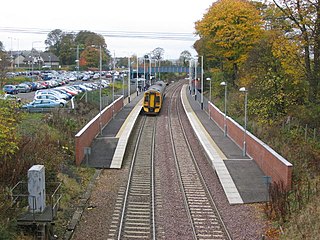
Dalgety Bay railway station serves the town of Dalgety Bay in Fife, Scotland. Lying on the Fife Circle and EdinburghーDundee lines, it is managed by ScotRail. It is currently the nearest railway station to Fordell Firs Camp site, the Scottish national headquarters for The Scout Association in Scotland, part of Scouting in Scotland.

Greta is a small town in the Hunter Region of New South Wales, Australia.

Uranquinty is a small town approximately 15 kilometres (9 mi) south of Wagga Wagga, in the Riverina region of New South Wales, Australia. The population of the town, often referred to as "Quinty", is 909.

Hopefield is a rural community in the central south part of the Riverina. It is situated by road, about 12 kilometres south west of Balldale and 12 kilometres north east of Corowa. At the 2006 census, Hopefield had a population of 308 people.
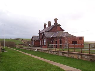
Kettleness was a railway station on the Whitby, Redcar and Middlesbrough Union Railway from 1883 to 1958 serving the remote village of Kettleness. The main station building is still extant and serves as a scouting centre.

Wangi Power Station is a heritage-listed former coal-fired power station at Wangi Wangi, City of Lake Macquarie, New South Wales on Lake Macquarie. The power station operated between 1956 and 1986 and supplied electricity to New South Wales. It was once the largest in the state. The 12,000-square-metre (130,000 sq ft) building was listed on the New South Wales State Heritage Register on 2 April 1999.


