
The Blue Nile is a river originating at Lake Tana in Ethiopia. It travels for approximately 1,450 km (900 mi) through Ethiopia and Sudan. Along with the White Nile, it is one of the two major tributaries of the Nile and supplies about 85.6% of the water to the Nile during the rainy season.

Below is a list of the 18 states of the Sudan. Prior to 9 July 2011, the Republic of the Sudan was composed of 25 states. The ten southern states now form part of the independent country of South Sudan. Two additional states were created in 2012 within the Darfur region, and one in 2013 in Kordofan, bringing the total to 18.

Sennar is a city on the Blue Nile in Sudan and possibly the capital of the state of Sennar. It remains publicly unclear whether Sennar or Singa is the capital of Sennar State. For several centuries it was the capital of the Funj Kingdom of Sennar.

Gezira, also spelt Al Jazirah, is one of the 18 states of Sudan. The state lies between the Blue Nile and the White Nile in the east-central region of the country. It has an area of 27,549 km2. The name comes from the Arabic word for island. Wad Madani is the capital of the state. Gezira is known as an irrigated cotton-producing state as it is a well-populated area that is suitable for agriculture.

Sennar is one of the 18 wilayat or states of Sudan. It has an area of 37,844 km² and a population of approximately 1,100,000 (2000).

The Funj Sultanate, also known as Funjistan, Sultanate of Sennar or Blue Sultanate due to the traditional Sudanese convention of referring to black people as blue was a monarchy in what is now Sudan, northwestern Eritrea and western Ethiopia. Founded in 1504 by the Funj people, it quickly converted to Islam, although this embrace was only nominal. Until a more orthodox Islam took hold in the 18th century, the state remained an "African empire with a Muslim façade". It reached its peak in the late 17th century, but declined and eventually fell apart in the 18th and 19th centuries. In 1821, the last sultan, greatly reduced in power, surrendered to the Ottoman Egyptian invasion without a fight.

The Gezira Scheme is one of the largest irrigation projects in the world. It is centered on the Sudanese state of Al Jazirah, just southeast of the confluence of the Blue and White Nile rivers at the city of Khartoum. The Gezira Scheme was begun by the British while the area was governed as part of Anglo-Egyptian Sudan. Water from the Blue Nile is distributed through canals and ditches to tenant farms lying between the Blue and White Nile rivers.

The Islamization of the Sudan region (Sahel) encompasses a prolonged period of religious conversion, through military conquest and trade relations, spanning the 8th to 16th centuries.

The current national emblem of Sudan was adopted in 1985.

The Butana, historically called the Island of Meroë, is the region between the Atbara and the Nile in the Sudan. South of Khartoum it is bordered by the Blue Nile and in the east by Lake Tana in Ethiopia. It should not be confused with the Gezira, the region west of the Blue Nile and east of the White Nile.
Er Roseires is a town in eastern Sudan 60 km from the border with Ethiopia.

The Dinder River is a tributary of the Blue Nile. It flows through Ethiopia and Sudan for 480 kilometres (300 mi).
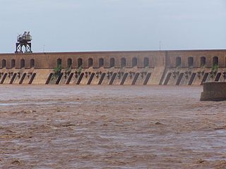
The Sennar Dam is an irrigation dam on the Blue Nile near the town of Sennar in the Al Jazirah region of Sudan. The dam is 3,025 metres (9,925 ft) long and has a maximum height of 40 metres (130 ft). It was designed by the Scottish engineer Sir Murdoch MacDonald, begun in 1914 and completed in 1925 by the British contractor S Pearson & Sons.
Energy in Sudan describes energy and electricity production, consumption and imports in Sudan. The chief sources of energy in 2010 were wood and charcoal, hydroelectric power, and oil. Sudan is a net energy exporter. Primary energy use in Sudan was 179 TWh and 4 TWh per million persons in 2008.
Singa is a town located in the Sennar State of Sudan at an elevation of 439 meters above sea level. The town is situated on the west bank of the Blue Nile at a distance of 360 kilometers to the southeast of the capital, Khartoum, and 60 kilometers from Sennar city. Its population was recorded to be 259,000 in 2002.

The Sudans is a region in Northeast Africa comprising the sovereign countries of North Sudan and South Sudan. Until 2011, the region was united under a state known as the Republic of the Sudan.
The Hamaj Regency was a political order in the region of modern-day central Sudan from 1762 to 1821. During this period the ruling family of the Funj Sultanate of Sennar continued to reign, while actual power was exercised by the regents.

The Egyptian conquest of Sudan was a major military and technical feat. Fewer than 10,000 men set off from Egypt, but, with some local assistance, they were able to penetrate 1,500 km up the Nile River to the frontiers of Ethiopia, giving Egypt an empire as large as Western Europe.

The kingdom of Fazughli was a precolonial state in what is now southeastern Sudan and western Ethiopia. Oral traditions assert its establishment to refugees from the Nubian kingdom of Alodia, after its capital Soba had fallen to Arabs or the Funj in c. 1500. Centered around the mountainous region of Fazughli on the Blue Nile and serving as a buffer between the Funj sultanate and the Ethiopian empire, the kingdom lasted until its incorporation into the Funj sultanate in 1685.
Al Tekyna is a village located on the Blue Nile, in Sennar, Sudan, where the Nile borders on the southern and western side of the forest, in the north the village bordered by big agricultural land, this land honored by the people in the village the lands are cultivated in the autumn season, and most of the villagers depend in their food on the corn and millet produces by this land, which have now been turned into farms and are within the villages of Local and Wa Al Abbas east of Sennar, Al-Tekina village is characterized by its strategic location and is the first village after the bridge connecting Sennar city, followed by the Banat village, Abogaili then Al-Arkikiin village.