
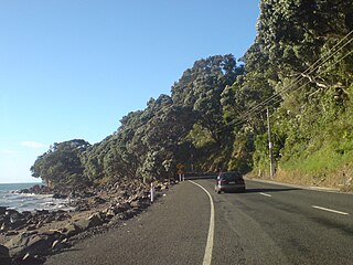
Coromandel, also called Coromandel Town to distinguish it from the wider district, is a town on the Coromandel Harbour, on the western side of the Coromandel Peninsula, which is in the North Island of New Zealand. It is 75 kilometres east of the city of Auckland, although the road between them, which winds around the Firth of Thames and Hauraki Gulf coasts, is 190 km long. The population was 1,930 as of June 2023.

The Konkan is a stretch of land by the western coast of India, bound by the river Daman Ganga at Damaon in the north, to Anjediva Island next to Karwar town in the south; with the Arabian Sea to the west and the Deccan plateau to the east. The hinterland east of the coast has numerous river valleys, riverine islands and the hilly slopes known as the Western Ghats; that lead up into the tablelands of the Deccan. The region has been recognised by name, since at least the time of Strabo in the third century CE. It had a thriving mercantile port with Arab tradesmen from the 10th century. The best-known islands of Konkan are Ilhas de Goa, the site of the Goa state's capital at Panjim, and the Seven Islands of Bombay, on which lies Mumbai, the capital of Maharashtra and the headquarters of the Konkan Division.

The Coromandel Coast is the southeastern coastal region of the Indian subcontinent, bounded by the Utkal Plains to the north, the Bay of Bengal to the east, the Kaveri delta to the south, and the Eastern Ghats to the west, extending over an area of about 22,800 square kilometres. The coast has an average elevation of 80 metres and is backed by the Eastern Ghats, a chain of low lying and flat-topped hills.
The Thames-Coromandel District is a territorial authority district in the North Island of New Zealand, covering all the Coromandel Peninsula and extending south to Hikutaia.
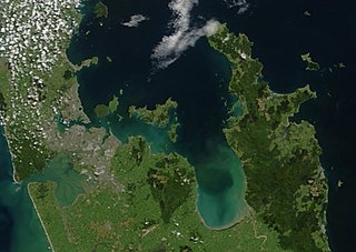
The Hauraki Gulf / Tīkapa Moana is a coastal feature of the North Island of New Zealand. It has an area of 4000 km2, and lies between, in anticlockwise order, the Auckland Region, the Hauraki Plains, the Coromandel Peninsula, and Great Barrier Island. Most of the gulf is part of the Hauraki Gulf Marine Park.
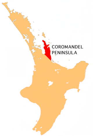
The Coromandel Peninsula on the North Island of New Zealand extends 85 kilometres (53 mi) north from the western end of the Bay of Plenty, forming a natural barrier protecting the Hauraki Gulf and the Firth of Thames in the west from the Pacific Ocean to the east. It is 40 kilometres (25 mi) wide at its broadest point. Almost its entire population lives on the narrow coastal strips fronting the Hauraki Gulf and the Bay of Plenty. In clear weather the peninsula is clearly visible from Auckland, the country's biggest city, which lies on the far shore of the Hauraki Gulf, 55 kilometres (34 mi) to the west. The peninsula is part of the Thames-Coromandel District and the Waikato Region.
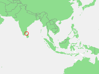
The Gulf of Mannar is a large shallow bay forming part of the Laccadive Sea in the Indian Ocean with an average depth of 5.8 m (19 ft). It lies between the southeastern tip of India and the west coast of Sri Lanka, in the Coromandel Coast region. The chain of low islands and reefs known as Adam’s Bridge or Rama Setu, which includes Mannar Island, separates the Gulf of Mannar from Palk Bay, which lies to the north between India and Sri Lanka. The estuaries of Thamirabarani River and Vaippar River of South India and the Malvathu Oya of Sri Lanka drain into the Gulf. The dugong is found here.

Cape Colville is the northernmost point of the Coromandel Peninsula in New Zealand's North Island. It lies 85 kilometres north of Thames, and 70 kilometres northeast of the city of Auckland, on the other side of the Hauraki Gulf. The small settlements of Port Jackson and Fletcher Bay lie immediately to the west and east respectively of the cape.
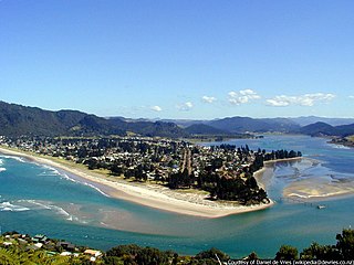
The town of Pauanui is on the east coast of the Coromandel Peninsula in the North Island of New Zealand. It lies at the mouth of the Tairua River on its south bank, directly opposite the larger town of Tairua.

Tairua is a beachside town located on the east coast of the Coromandel Peninsula in the North Island of New Zealand in the Thames-Coromandel District. It is located 150 kilometers east of Auckland and 125 kilometers north of Tauranga. It lies at the mouth of the Tairua River on its north bank and on the small Paku Peninsula. As the 2023 census, the town had a permanent population of 1,630. It is the Tairua is a Māori name which translates literally as tai: tides, rua: two.

The Tairua River is located on the Coromandel Peninsula in the North Island of New Zealand.

Slipper Island is located 3 kilometres (1.9 mi) to the east of the Coromandel Peninsula in New Zealand's North Island and 8 kilometres (5 mi) southeast of the town of Pauanui.

Te Whanganui-A-Hei Marine Reserve is in the southern part of Mercury Bay on the Coromandel Peninsula in New Zealand covering an area of 840 hectares. On the coast of the mainland, it stretches from Cook Bluff in the north-west to the northern end of Hahei Beach in the south-east. Its offshore extremes run from Motukorure Island through Waikaranga Island to Okorotere Island and the northern end of Mahurangi Island.

Coromandel is a Brazilian municipality, located in the southeast region of the country, in the state of Minas Gerais. Its population is estimated at 27,966 people as of 2020. The municipality (município) of Coromandel is located 495 km from the state capital Belo Horizonte, and 673 km from São Paulo. Coromandel is one of the municipalities of the Triângulo Mineiro/Alto Paranaíba micro region and its territorial size is 3,296 km2. Its borders are limited in the north by state of Goiás and Guarda-Mor municipality, east by the municipalities of Vazante, Lagamar, Patos de Minas and Guimarânia, west by the municipalities of Abadia dos Dourados and Monte Carmelo, and south by Patrocínio municipality. Coromandel has six districts: Alegre, Santa Rosa, Pântano de Santa Cruz, Lagamar dos Coqueiros and Mateiro.

The Moehau Range is the northernmost range on the Coromandel Peninsula, extending from the settlement of Colville, New Zealand northwards to the tip of the peninsula. Mount Moehau is the highest point of the range, at 892m above sea level.
Coromandel East is a semi-rural suburb of Adelaide, South Australia. It lies within the City of Onkaparinga and has postcode 5157.
Matakana is a former New Zealand parliamentary electorate in the Thames-Coromandel District, which existed for one parliamentary term from 1993 to 1996, and was held by Graeme Lee. In 1994, Lee defected from the National Party to the Christian Democrat Party.

The Malabar Coast is the southwestern region of the Indian subcontinent. It generally refers to the western coastline of India stretching from Konkan to Kanyakumari. Geographically, it comprises one of the wettest regions of the subcontinent, which includes the Kanara region of Karnataka and all of Kerala.
Mulagada is a neighbourhood in the city of Visakhapatnam, India. It is one of the 46 mandals in Visakhapatnam District. It is under the administration of Visakhapatnam revenue division and the headquarters is located at Mulagada. It is located on the south fringe of Visakhapatnam city.

Motuhoa Island is in the western Bay of Plenty of New Zealand's North Island, in Tauranga Harbour, over 2 km (1.2 mi) long, up to 35 m (115 ft) high and about 1.25 km (0.78 mi) southeast of Ōmokoroa, with 5 km (3.1 mi) of low cliff, which on the north is up to 8 m (26 ft) high, with almost no vegetation. A boat ramp is near the east tip of the island, on the north shore. For the 2018 census, the island had a population too small to record. Shore skinks live on the beaches.


