A transform fault or transform boundary, is a fault along a plate boundary where the motion is predominantly horizontal. It ends abruptly where it connects to another plate boundary, either another transform, a spreading ridge, or a subduction zone. A transform fault is a special case of a strike-slip fault that also forms a plate boundary.

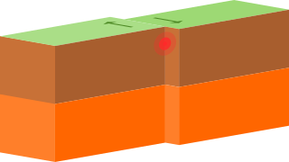
In plate tectonics, a divergent boundary or divergent plate boundary is a linear feature that exists between two tectonic plates that are moving away from each other. Divergent boundaries within continents initially produce rifts, which eventually become rift valleys. Most active divergent plate boundaries occur between oceanic plates and exist as mid-oceanic ridges.

Barrier islands are a coastal landforms—a type of dune system and sand island—where an area of sand has been formed by wave and tidal action parallel to the mainland coast. They usually occur in chains, consisting of anything from a few islands to more than a dozen. They are subject to change during storms and other action, but absorb energy and protect the coastlines and create areas of protected waters where wetlands may flourish. A barrier chain may extend for hundreds of kilometers, with islands periodically separated by tidal inlets. The largest barrier island in the world is Padre Island of Texas, United States, at 113 miles (182 km) long. Sometimes an important inlet may close permanently, transforming an island into a peninsula, thus creating a barrier peninsula, often including a beach, barrier beach. Though many are long and narrow, the length and width of barriers and overall morphology of barrier coasts are related to parameters including tidal range, wave energy, sediment supply, sea-level trends, and basement controls. The amount of vegetation on the barrier has a large impact on the height and evolution of the island.
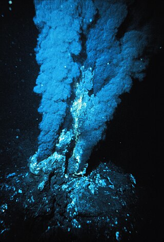
Hydrothermal vents are fissures on the seabed from which geothermally heated water discharges. They are commonly found near volcanically active places, areas where tectonic plates are moving apart at mid-ocean ridges, ocean basins, and hotspots. Hydrothermal deposits are rocks and mineral ore deposits formed by the action of hydrothermal vents.
Upper shoreface refers to the portion of the seafloor that is shallow enough to be agitated by everyday wave action, the wave base.
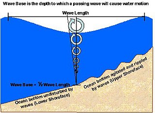
Lower shoreface refers to the portion of the seafloor, and the sedimentary depositional environment, that lies below the everyday wave base.
The wave base, in physical oceanography, is the maximum depth at which a water wave's passage causes significant water motion. At water depths deeper than the wave base, bottom sediments and the seafloor are no longer stirred by the wave motion above.

The seabed is the bottom of the ocean. All floors of the ocean are known as 'seabeds'.

A mid-ocean ridge (MOR) is a seafloor mountain system formed by plate tectonics. It typically has a depth of about 2,600 meters (8,500 ft) and rises about 2,000 meters (6,600 ft) above the deepest portion of an ocean basin. This feature is where seafloor spreading takes place along a divergent plate boundary. The rate of seafloor spreading determines the morphology of the crest of the mid-ocean ridge and its width in an ocean basin.
Coastal morphodynamics refers to the study of the interaction and adjustment of the seafloor topography and fluid hydrodynamic processes, seafloor morphologies and sequences of change dynamics involving the motion of sediment. Hydrodynamic processes include those of waves, tides and wind-induced currents.
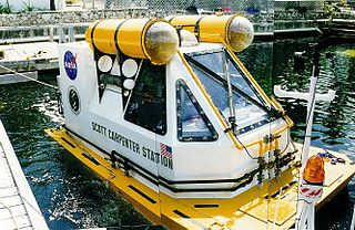
The Scott Carpenter Space Analog Station was designed by the National Aeronautics and Space Administration (NASA) as a seafloor research station—or underwater habitat. It was designed by NASA Aquanaut, Dennis Chamberland and Marine Engineer, Joseph M. Bishop and named in honor of the Mercury project astronaut and SEALAB aquanaut M. Scott Carpenter. It was used on two missions in the summer of 1997 and 1998 on the seafloor near Key Largo, Florida at the Marine Resources Development Foundation.

Poseidon Linux is a Linux distribution, a complete operating system, originally based on Kurumin, now based on Ubuntu. It is developed and maintained by developers located at the Rio Grande Federal University in Rio Grande do Sul, Brazil, and the MARUM institute in Germany.

Eridania Lake is a theorized ancient lake on Mars with a surface area of roughly 1.1 million square kilometers. It is located at the source of the Ma'adim Vallis outflow channel and extends into Eridania quadrangle and the Phaethontis quadrangle. As Eridania Lake dried out in the late Noachian epoch it divided into a series of smaller lakes.

In geology, depositional environment or sedimentary environment describes the combination of physical, chemical, and biological processes associated with the deposition of a particular type of sediment and, therefore, the rock types that will be formed after lithification, if the sediment is preserved in the rock record. In most cases, the environments associated with particular rock types or associations of rock types can be matched to existing analogues. However, the further back in geological time sediments were deposited, the more likely that direct modern analogues are not available.

At a flat coast or flat shoreline, the land descends gradually into the sea. Flat coasts can be formed either as a result of the sea advancing into gently sloping terrain or through the abrasion of loose rock. They may be basically divided into two parallel strips: the shoreface and the beach.
Production system may refer to:
A sulfide deposit is an ore body or rock containing a great deal of sulfide minerals.
Seabed mining, also known as Seafloor mining is the recovery of minerals from the seabed by techniques of underwater mining. The concept includes mining at shallow depths on the continental shelf and deep-sea mining at greater depths associated with tectonic activity, hydrothermal vents and the abyssal plains. While there is opportunity for economical mineral extraction at areas of high concentration of valuable minerals, there is also significant risk of ecological damage of unknown and to some degree, unpredictable, extent. Increasing requirements for minerals and metals, largely for use in the technology sector, has led to renewed interest in exploitation of seabed mineral resources, including massive polymetallic sulfide deposits around hydrothermal vents, cobalt-rich crusts on the sides of seamounts and fields of manganese nodules on the abyssal plains.