Si Kai สีกาย | |
---|---|
Tambon | |
Country | Thailand |
Province | Nong Khai |
District | Mueang Nong Khai |
Area | |
• Total | 20.46 km2 (7.90 sq mi) |
Population (2008) [1] | |
• Total | 3,490 |
• Density | 170/km2 (440/sq mi) |
Postal Code | 43000 |
Geocode | 430119 |
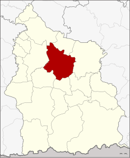
Si Kai (Thai : สีกาย) is a sub-district ( tambon ) 18 kilometers east of the provincial capital of Nong Khai in Nong Khai Province, Thailand.
Thai, Central Thai or Ayutthaya or Siamese, is the sole official and national language of Thailand and the first language of the Central Thai people and vast majority of Thai of Chinese origin. It is a member of the Tai group of the Kra–Dai language family. Over half of Thai vocabulary is derived from or borrowed from Pali, Sanskrit, Mon and Old Khmer. It is a tonal and analytic language.
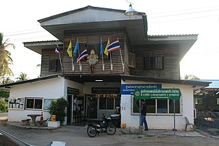
Tambon is a local governmental unit in Thailand. Below district (amphoe) and province (changwat), they form the third administrative subdivision level. As of 2016 there were 7,255 tambons, not including the 180 khwaeng of Bangkok, which are set at the same administrative level, thus every district contains eight to ten tambon. Tambon is usually translated as "township" or "subdistrict" in English — the latter is the recommended translation, though also often used for king amphoe, the designation for a subdistrict acting as a branch of the parent district. Tambon are further subdivided into 69,307 villages (muban), about ten per tambon. Tambon within cities or towns are not subdivided into villages, but may have less formal communities called chumchon (ชุมชน) that may be formed into community associations.
Nong Khai is a city in north-east Thailand. It is the capital of Nong Khai Province. Nong Khai city is administered as Mueang Nong Khai District.
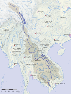
The sub-district is in the northeast of Mueang Nong Khai District on the shore of the Mekong River, which is marks the northern boundary of the sub-district. To the west is Hin Ngom Sub-district, to the south Lao Tang Kham of Amphoe Phon Phisai, and to the east the sub-district Ban Duea.
The Mekong is a trans-boundary river in Southeast Asia. It is the world's twelfth longest river and the seventh longest in Asia. Its estimated length is 4,350 km (2,703 mi), and it drains an area of 795,000 km2 (307,000 sq mi), discharging 475 km3 (114 cu mi) of water annually. From the Tibetan Plateau the river runs through China's Yunnan Province, Myanmar, Laos, Thailand, Cambodia, and Vietnam. In 1995, Laos, Thailand, Cambodia, and Vietnam established the Mekong River Commission (MRC) to manage and coordinate use of the Mekong's resources. In 1996 China and Myanmar became "dialogue partners" of the MRC and the six countries now work together in a cooperative framework.
The sub-district was created effective 1 August 1982 by splitting off seven villages from Hin Ngom Sub-district. [2] The tambon administrative organization (TAO) as the local government unit was established on 13 February 1997. [3]
The sub-administrative district consists of eight administrative villages ( muban ).
Muban is the lowest administrative sub-division of Thailand. Usually translated as village and sometimes as hamlet, they are a subdivision of a tambon. As of 2008, there were 74,944 administrative muban in Thailand. As of the 1990 census, the average village consisted of 144 households or 746 persons.
1. | Ban Chom Chaeng | บ้านจอมแจ้ง |
2. | Ban Si Kai Tai | บ้านสีกายใต้ |
3. | Ban Fai Taek | บ้านฝายแตก |
4. | Ban Pong | บ้านบง |
5. | Ban Dong Wen | บ้านดงเวร |
6. | Ban Si Kai Nuea | บ้านสีกายเหนือ |
7. | Ban Santi Suk | บ้านสันติสุข |
8. | Ban Sangkhom Phatthana | บ้านสังคมพัฒนา |
Khai Bang Rachan is a district (amphoe) of Sing Buri Province, central Thailand.
Nong Prue is a district (amphoe) in the northeastern part of Kanchanaburi Province, central Thailand.
Wang Chan is a district (amphoe) in the northern part of Rayong Province, eastern Thailand.
Sakhrai is a district (amphoe) of Nong Khai Province, northeastern Thailand.
Nong Muang Khai is a district (amphoe) in the central part of Phrae Province, northern Thailand.
Mueang Suang is a district (amphoe) of Roi Et Province, in northeastern Thailand.
Taphan Hin is a district (amphoe) in the central part of Phichit Province, central Thailand.
Pho Tak is a district (amphoe) of Nong Khai Province, northeastern Thailand.
Nong Hin is a district (amphoe) of Loei Province, northeastern Thailand.
Fao Rai is a district (amphoe) of Nong Khai Province, northeastern Thailand.
Rattanawapi is a district (amphoe) of Nong Khai Province, northeastern Thailand.
Mueang Nong Khai is the capital district of Nong Khai Province, northeastern Thailand.
Pak Khat is a district (amphoe) in the eastern part of Bueng Kan Province, northeastern Thailand.
So Phisai is a district (amphoe) of Bueng Kan Province, northeastern Thailand.
Na Thom is a district (amphoe) of Nakhon Phanom Province, northeastern Thailand.
Chai Wan is a district (amphoe) in the southeastern part of Udon Thani Province, northeastern Thailand.
Khamcha-i is a district (amphoe) of Mukdahan Province, northeastern Thailand.
Mueang Sisaket is the capital district of Sisaket Province, northeastern Thailand.
Nong Hong is a district (amphoe) in the western part of Buriram Province, northeastern Thailand.
Khai Si is a sub-district (tambon) in Mueang Bueng Kan District, in Bueng Kan Province, northeastern Thailand. As of 2012, it had a population of 5,294 people. It lies on Highway 212 and the Mekong River and border with Laos, west of Bueng Kan and east of Ho Kham.
![]() | This Thailand-related article is a stub. You can help Wikipedia by expanding it. |