
Saint John is one of the Virgin Islands in the Caribbean Sea and a constituent district of the United States Virgin Islands (USVI), an unincorporated territory of the United States.

Cruz Bay, U.S. Virgin Islands is the main town on the island of Saint John in the United States Virgin Islands. According to the 2000 Census, Cruz Bay has a population of 2,743 people.
Thatch Cay is a small, uninhabited 230 acre island one-half mile off the northeastern coast of Saint Thomas. Its highest peak is 482 feet. It is one of the last privately held, undeveloped islands in the U.S. Virgin Islands.
The area code (340) is the local telephone area code of U.S. Virgin Islands. The (340) area code was created during a split from the original (809) area code, which began permissive dialing on 1 June 1997 and ended 30 June 1998.

Cinnamon Bay is a body of water and a beach on St. John island, within Virgin Islands National Park, in the United States Virgin Islands.
Fort Purcell is a ruined fort near Pockwood Pond on the island of Tortola in the British Virgin Islands.
Not to be confused with Mandal, Saint John, U.S. Virgin Islands

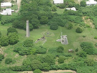
Catherineberg Sugar Mill Ruins is an historic site located in the Virgin Islands National Park, east of Cruz Bay on Saint John, U.S. Virgin Islands. The ruins are an example of an 18th-century sugar and rum factory.
Estate Catherineberg is a historic mansion on Denmark Hill in Charlotte Amalie, on Saint Thomas island, in the United States Virgin Islands.
Adrian is a neighborhood on the island of Saint John in the United States Virgin Islands. Much of this area is part of Virgin Islands National Park. The Catherineburg Sugar Mill Ruins are in Adrian. The only grove of bamboo on St. John can be found here, to the east of John Head Road.
Annaberg is a former sugar factory and plantation on the island of Saint John in the United States Virgin Islands. It is uninhabited and part of Virgin Islands National Park.
L'Esperance is a former plantation on the island of Saint John in the United States Virgin Islands. It is uninhabited and part of Virgin Islands National Park. The L'Esperance trail is maintained by the National Park Service.
Lameshur is a former plantation on the island of Saint John in the United States Virgin Islands. It is inside Virgin Islands National Park and home to the Virgin Islands Environmental Resource Station (VIERS). The Tektite program placed two underwater habitats in Great Lameshur Bay and the Tektite Underwater Habitat Museum is located in the VIERS camp. The road to Lameshur is unmaintained and 4 wheel drive vehicles are often required. The University of the Virgin Islands has a research station and dock in Lameshur on Yawzi Point.
Leinster Bay is a bay and former sugar cane plantation on the island of Saint John in the United States Virgin Islands. It is uninhabited and part of Virgin Islands National Park. Visitors can park at Annaberg and hike the Leinster Bay trail to access the bay, which is a popular snorkeling spot. Waterlemon Cay is a small cay in Leinster Bay. The ruins of the plantation's estate house can be reached by continuing past the bay and up the Johnny Horn Trail.
Mary Point is an uninhabited peninsula on the island of Saint John in the United States Virgin Islands. There are no roads or trails and steep cliffs prevent access from the water. Although Mary Point once housed a small sugar cane plantation, the area is now overgrown with thick forest. The foundation and crumbling walls of Mary Point Estate can be seen from the Francis Bay trail. It is part of Virgin Islands National Park. Mary Creek, the shallow bay on the east side, is a popular spot for fly fishing and kitesurfing.
Reef Bay is a neighborhood and bay on the island of Saint John in the United States Virgin Islands. Most of this area is part of Virgin Islands National Park. The inhabited portion is along the west side of Reef Bay, near Fish Bay. The Reef Bay Sugar Factory ruins are located in the center of Reef Bay, in an area known as Genti Bay. The nearly 3 mile long Reef Bay Trail is a National Park Service maintained hiking trail that runs through the area from Centerline Road to Genti Bay.
Whim is a settlement on the island of Saint Croix in the United States Virgin Islands.


