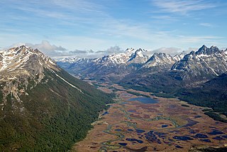
Charlevoix is a cultural and natural region located in Quebec, on the north shore of the Saint Lawrence River as well as in the Laurentian Mountains area of the Canadian Shield. This dramatic landscape includes rolling terrain, fjords, headlands and bays; the region was designated a World Biosphere Reserve by UNESCO in 1989.

Cairnsmore of Fleet is a mountain in the Scottish Lowlands, on the edge of the Galloway Forest Park. The mountain forms an unafforested granite massif, whose highest point is about 10 kilometres (6.2 mi) east of Newton Stewart. It is the highest of the "Solway Hills", and the southernmost of Scotland's 219 Grahams. The view to the south takes in the Cree Estuary and Wigtown Bay, and extends as far as the Lake District, the Isle of Man and Snowdonia. The highest summits of the Galloway Hills can be seen to the north, and Ireland is in the view to the west.
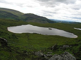
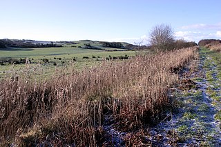
The Round Loch of Glenhead is a small upland single basin loch in Dumfries and Galloway. It is situated within Galloway Forest Park to the west of the hill Craiglee. It forms a pair with the nearby Long Loch of Glenhead. Both lochs are of similar sizes and each have a small island. The two lochs are separated from Loch Valley and Loch Naroch to the north by the Rig of the Jarkness. The loch is drained to the southwest by Round Loch Burn, which after joining into Glenhead Burn flows into Loch Trool.

Mantaritza Biosphere Reserve is situated to the north of Golyama Syutka Peak in the Rhodope Mountains in Bulgaria, and covers an area of 1319,9 hectares. The reserve was established in 1968 to protect the old coniferous forests and the biotopes of the Western capercaillie. The area was declared as biosphere reserve in 1977. It represents century-old forests of pure and mixed stands of Norway spruce (Picea abies), European birch (Fagus sylvatica) and European silver fir (Abies alba). The reserve is situated in the Bulgarian Floristic sub-region of West Rhodope within the Central European mountain biotic province. The varied fauna includes brown bear (Ursus arctos), red deer (Cervus elaphus), roe deer (Capreolus capreolus), wild boar, pine marten (Martes martes), European badger (Meles meles), hazel grouse (Bonasa bonasia), black woodpecker (Dryocopus martius) and European crested tit (Parus cristatus).
The Biosffer Dyfi, or Dovey Biosphere is situated at the coast of south-central Wales in the estuary of the Dyfi River, and is a biosphere reserve representative of salt marshes and estuarine systems in the west of the United Kingdom. The estuary forms one of the most important wildfowl and shorebird centres in Wales and also comprises a Ramsar site.

The Vessertal-Thüringen Forest is a biosphere reserve located in the Thuringian forest and is crossed by the famous German hiking trail ‘Rennsteig’. The biosphere reserve is part of Thuringian Forest Nature Park and comprises mainly large contiguous mountain spruce forests. Furthermore, beech forests, block and rock forest communities, high-elevation raised bogs can be found. Upland, low-lying and valley meadows reflect the extensive use by people for dairy cow raising. The entire biosphere reserve has been designated as Natura 2000 site and European Bird Protection Area because of black grouse and black stork populations.
Situated north of Norwich on the Norfolk coast, the North Norfolk Coast biosphere reserve was a biosphere reserve until 2014 when its status was withdrawn. The area includes a wide range of habitats, from intertidal sands and muds, through shingle ridges, to saltwater and freshwater marshes. The saltmarshes are of great value for breeding and wintering wildfowl and includes a large breeding colony of common seals. Other habitats comprise mires, river valleys, heathlands, chalk and cliff-top grasslands, woodlands and farmland.
The Iroise National Nature Reserve is a French Biosphere reserve consisting of three inhabited islands, as well as the Molène archipelago which consists of around twenty smaller islands, plus the waters between the islands. All the major ecosystems of the Atlantic biogeographical region are represented: the marine environment, beaches, cliffs with Atlantic coastal vegetation, heathlands and grasslands.
The Champlain-Adirondack Biosphere Reserve is a UNESCO-designated biosphere reserve.
The Lake Tana Biosphere Reserve is located in the Amhara National Regional State approximately 563 km northwest of Addis Ababa in the north-western part of Ethiopia. The biosphere reserve comprises Lake Tana, the largest lake in Ethiopia, the main source of the Blue Nile, which provides important ecosystem services. The area is a hotspot of biodiversity, internationally known as an Important Bird Area and is of global importance for agricultural genetic diversity. The area is characterized by an enormous heterogeneity of land uses and natural ecosystems.
The Magaliesberg Biosphere Reserve is located in South Africa between the cities of Pretoria and Johannesburg to the east and Rustenburg to the west. The reserve lies at the interface of two great African biomes — the Central Grassland Plateaux and the sub-Saharan savannah — and the remnants of a third biome, the Afro‐montane forest. The rich biodiversity includes floral species such as Aloe peglerae and Frithia pulchra, and faunal species such as the forest shrew, sable antelope and 443 bird species representing 46.6% of total bird species in the southern African sub-region.

Konza Prairie biosphere reserve was a UNESCO Biosphere Reserve encompassing the Konza Prairie Biological Station in north-eastern Kansas. It was designated a biosphere reserve in 1978 and was one of 17 reserves in the United States withdrawn from the programme in June 2017.

The Alakol Biosphere Reserve is a UNESCO Biosphere Reserve located in Kazakhstan, within the desert zone of Eurasia in the central part of the Alakol inter-mountain depression. The 193,089 hectares (745.52 sq mi) reserve lies on the Central Asian–Indian bird migration route. The wetlands of the reserve are of global significance as a habitat and as a nesting site for water birds.

Ría Lagartos Biosphere Reserve is a UNESCO Biosphere Reserve in the state of Yucatán, Mexico. The reserve is located at the eastern end of the coastal strip of the Yucatán Peninsula, with the Gulf of Mexico at its northern limit. The area encompasses coastal areas of the Gulf of Mexico and includes important wetlands designated under the Ramsar Wetlands Convention. The site presents a rich diversity of landscapes and ecosystems, such as mangroves, small estuaries, medium semi-evergreen forest, low deciduous forest, coastal dune vegetation, coastal lagoons, marshes (petenes) and savanna represented by tular vegetation, grasslands and reed beds that are the main nesting sites for marshland and sea birds.
The landscape of the Manicouagan – Uapishka Biosphere Reserve is dominated by the Saint Lawrence River to the south and the Manicouagan reservoir to the north, forming a circle visible from great distances, even from space. They are linked by a web of rivers, which flow through vast woodlands.

The West Estonian Archipelago Biosphere Reserve is a UNESCO Biosphere Reserve in Estonia, located in the West Estonian archipelago in the eastern Baltic Sea. The 15,600 square kilometres (6,000 sq mi) reserve comprises the islands of Saaremaa, Hiiumaa, Vormsi and Muhu, as well as numerous islets and marine parts. The islands are in the transition zone between temperate needle-leaf and broadleaf forest.

The Roztochya Biosphere Reserve is a UNESCO Biosphere Reserve in Ukraine. Roztochya, Ukraine, has a total size of 74,800 hectares (289 sq mi) with its main economic activities including agriculture, stock-breeding and fish farming. The site is located on the north-western edge of the Podillya Upland, 20 kilometres (12 mi) from the city of Lviv, with an area of 30,000 hectares (120 sq mi). The site attracts visitors to its sanatoria and there are plans for developing business and tourism. There is on-going and planned cooperation with Poland in the Roztochya region.

The Red River Delta Biosphere Reserve is a UNESCO biosphere reserve in the coastal region of northern Vietnam. Mangroves and intertidal habitats of the Red River Delta form wetlands of high biodiversity especially in the Xuan Thuy and Tien Hai districts. These wetlands are of global importance as migratory sites for several bird species.
The Sinan Dadohae biosphere reserve is located in the southwest of the Republic of Korea and consists of 1,000 islands including Heuksando, Hongdo, Bigeumdo, Dochodo and Jeungdo. The total area consists of five hundreds islands, with more than 1,000km of coastline. A large tidal flat, an important habitat for marine animals and rare migratory birds, also supports fishing and salt production for local people.