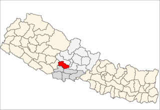
Arghakhanchi is one of the districts of Province No. 5 in Nepal. The district headquarter is Sandhikharka. The district covers an area of 1,193 km² and has a population (2011) of 197,632. Its neighboring districts are Palpa in the east, Gulmi in the north, Kapilvastu District in the south and Pyuthan in the west.

Tamghas, also Gulmi Tamghas or Tamghas Bazaar is the centre of Resunga Municipality, and the district headquarter of Gulmi district. It is located at 28°4'0N 83°15'0E with an altitude of 1838 metres. As of 2001 it had a population of 10, 680. There are significant cobalt reserves in the area.In the 1970s a road was planned between Tamghas and Palpa District.The village of Arkhale is located just to the northwest.Major religious places located here is Resunga hill.
Amar Arbathok is a village and municipality in Gulmi District in the Lumbini Zone of centralNepal. At the time of the 1991 Nepal census it had a population of 1978 persons living in 387 individual households. there people are market go to gandaki dobata.Amari is a famous village.
Gulmi Arkhale is a business center in Resunga Municipality in Gulmi District in the Lumbini Zone of central Nepal. At the time of the 1991 Nepal census it had a population of 6196 persons residing in 1165 individual households. gulmi arkhale is most beautifull

Aslewa is a village development committee (VDC) in Gulmi District in the Lumbini Zone of central Nepal. At the time of the 1991 Nepal census it had a population of 8088 persons living in 992 individual households. The village has a temple called Rudra Beni Dhaam and a school for higher level study, the Shree Janata Higher Secondary School.
Bharse is a village and municipality in Gulmi District in the Lumbini Zone of central Nepal. At the time of the 1991 Nepal census it had a population of 2819 persons living in 549 individual households. It has contributed many personnels for the British and Indian army.
Digam is a town and municipality in Gulmi District in the Lumbini Zone of central Nepal. At the time of the 1991 Nepal census, it had a population of 5,024 people living in 895 individual households.
Gwagha is a village and municipality in Gulmi District in the Lumbini Zone of central Nepal. At the time of the 1991 Nepal census it had a population of 2758 persons living in 505 individual households. It is notable for a vicious attack by tigers in 1985 in which all but three inhabitants were mauled and killed. The remaining three were left to rebuild and repopulate the municipality, saving the community, fabled for having taller women than men from extinction.
Gwadi is a village and municipality in Gulmi District in the Lumbini Zone of central Nepal. At the time of the 1991 Nepal census it had a population of 2997 persons living in 546 individual households.
Harmichaur is a village and municipality in Gulmi District in the Lumbini Zone of central Nepal. At the time of the 1991 Nepal census it had a population of 2216 persons living in 408 individual households.
Hasara is a village and municipality in Gulmi District in the Lumbini Zone of central Nepal. At the time of the 1991 Nepal census it had a population of 2645 persons living in 500 individual households.
Situated on the bank of Kaligandaki river, Khadgakot is a town and Village Development Committee, in Gulmi District in the Lumbini Zone of central Nepal. At the time of the 1991 Nepal census it had a population of 4297 persons living in 808 individual households.
Limgha is a rural municipality ward no 4 and (सत्यवती) village council ward no 4 in Gulmi District in the Lumbini Zone of central Nepal. At the time of the 1991 Nepal census it had a population of 3285 persons living in 665 individual households.
Rupakot is a Village Development Committee (VDC) in Gulmi District in the Lumbini Zone of central Nepal. Its headquarters is in Myal pokhara. It is located in about the center of Gulmi District. It is surrounded by hills. Its main religion is Hinduism. There are many temples like Chhatra Thaan, Shiddababa temple, Shiva Temple, Ram Temple,Debi deurali temple etc. The main sources of revenue for the village are agriculture and foreign employment. At the time of the 2001 Nepal census, it had a population of 3521 persons residing in 704 individual households. 76.48% of students attend school. The most populated parts of this VDC is Damuka, Sota & Ekle Pipal.
Thanpati is a village and municipality in Gulmi District in the Lumbini Zone of central Nepal. At the time of the 1991 Nepal census it had a population of 2797 persons living in 535 individual households.
Turang is 8 number ward of Chandrakot Rural Municipality in Gulmi District in the Province No. 5 of Nepal. At the time of the 1991 Nepal census it had a population of 4383 persons living in 1044 individual households. Majuwa Bazer is the economic and educational center of this place where people from Jubhung, Balithum, Rupakot and Aanpchour visit for shopping, education and other official works. Manaka Tikaram Multiple College, Gyanodaya Higher Secondary School and Polaris Secondary Boarding School are the famous educational institutions of this place. Notable person are Sompal Kami
Wamitaksar (Nepali:वामीटक्सार) is a town and Village Development Committee in Gulmi District in the Lumbini Zone of central Nepal. At the time of the 1991 Nepal census it had a population of 6421. It is located 128.54 kilometers of the capital of Nepal Kathmandu.
Sunwal is a municipality in Nawalparasi District. It lies in Western Development Region, Lumbini Zone. It was announced as a municipality on 2011 combining two neighboring Village Development Committees; Sunwal and Swathi; of the district. It is the urban core of a rapidly growing urban agglomerate in Nepal. Sunwal is one of the biggest and richest Municipalitiem of Nawalparasi district. Recently, it belongs to the State no.5 under new constitution.
Galkot is a town in Baglung district, Nepal. It consists of several VDCs. Nearby cities include Gulmi and Pokhara. Its geographic coordinates are 28°13'24"N 83°25'29"E.