
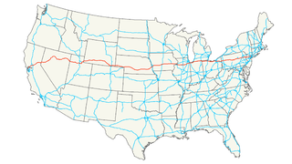
U.S. Route 101, or U.S. Highway 101 (US 101) is a north–south United States Numbered Highway that runs through the states of California, Oregon, and Washington, on the West Coast of the United States. It is also known as El Camino Real where its route along the southern and central California coast approximates the old trail which linked the Spanish missions, pueblos, and presidios. It merges at some points with California State Route 1 (SR 1).

Interstate 5 (I-5) is the main Interstate Highway on the West Coast of the United States, running largely parallel to the Pacific coast of the contiguous U.S. from Mexico to Canada. It travels through the states of California, Oregon, and Washington, serving several large cities on the U.S. West Coast, including San Diego, Los Angeles, Sacramento, Portland, and Seattle. It is currently the only continuous Interstate highway to touch both the Mexican border and the Canadian border. Upon crossing the Mexican border at its southern terminus, Interstate 5 continues to Tijuana, Baja California as Mexico Federal Highway 1. Upon crossing the Canadian border at its northern terminus, it continues to Vancouver as British Columbia Highway 99.
Interstate 80 (I-80) is an east–west transcontinental freeway in the United States that runs from downtown San Francisco, California, to Teaneck, New Jersey, in the New York City Metropolitan Area. The highway was designated in 1956 as one of the original routes of the Interstate Highway System. Its final segment was opened to traffic in 1986. It is the second-longest Interstate Highway in the United States, following I-90. The Interstate runs through many major cities including Oakland, Sacramento, Reno, Salt Lake City, Omaha, Des Moines, and Toledo, and passes within 10 miles (16 km) of Chicago, Cleveland, and New York City.
Interstate 880 (I-880) is an Interstate Highway in the San Francisco Bay Area connecting San Jose and Oakland, running parallel to the eastern shore of San Francisco Bay. For most of its route, I-880 is officially known as the Nimitz Freeway, after World War II fleet admiral Chester Nimitz, who retired to the Bay Area and lived on Yerba Buena Island.
Interstate 580 (I-580) is an 80-mile (129 km) east–west Interstate Highway in Northern California. The heavily traveled spur route of Interstate 80 runs from San Rafael in the San Francisco Bay Area to Interstate 5 near Tracy in the Central Valley. It provides a connection from the Bay Area to the southern San Joaquin Valley and Southern California via Interstate 5, as Interstate 5 bypasses the Bay Area to the east.
Interstate 780 (I-780) is an Interstate Highway in the San Francisco Bay Area of the U.S. state of California. It serves to connect Interstate 80 in Vallejo with Interstate 680 just north of the Benicia-Martinez Bridge in Benicia. It closely parallels the Carquinez Strait for its entire route. Originally, this segment was part of I-680 before that Interstate was extended and rerouted to Fairfield. The city-maintained Curtola Parkway continues west from I-80 to State Route 29 in Vallejo.
Interstate 380 (I-380) is a short 1.7-mile (2.7 km) east–west spur Interstate Highway in the San Francisco Bay Area of Northern California, connecting Interstate 280 in San Bruno to U.S. Route 101 near the San Francisco International Airport (SFO). The highway primarily consists of only three intersections: I-280, El Camino Real, and U.S. 101. Like the nearby I-280, I-380 never connects to Interstate 80, its parent Interstate Highway. However, there is no rule that says that spur routes need to.
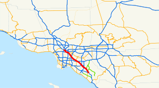
The Santa Ana Freeway is one of the principal freeways in Southern California, connecting Los Angeles and its southeastern suburbs including the freeway's namesake, the city of Santa Ana. The freeway begins at its junction with the San Diego Freeway, called the El Toro Y, in Irvine, signed as I-5. From there, it generally goes southeast to northwest to the East Los Angeles Interchange, where it takes the designation of U.S. Route 101 (US 101). It then proceeds 2.95 miles (4.75 km) northwest to the Four Level Interchange in downtown Los Angeles. Formerly, the entirety of the route was marked as US 101 until the 1964 highway renumbering, which truncated US 101 to the East Los Angeles Interchange and designated the rest of the freeway as I-5.

State Route 85 is a freeway which connects the cities of Mountain View and southern San Jose in the U.S. State of California. The route provides an alternate to U.S. Route 101, bypassing downtown San Jose and instead passing through the foothill cities of Los Gatos, Saratoga, and Cupertino, roughly paralleling the Santa Cruz Mountains up to its interchange with I-280. The highway intersects with major highways such as I-280, SR 17, and SR 87.

State Route 87, locally called the Guadalupe Freeway, is a north–south state highway entirely within the City of San Jose, California, United States. A very small portion between the Curtner Avenue exit and the Capitol Expressway Auto Mall exit is unincorporated county. Its name was changed from Guadalupe Parkway in 2004 after its entire constructed length was upgraded to a freeway. For most of its length, especially in Downtown San Jose, the highway follows the course of the Guadalupe River. Its southern terminus is at SR 85, and its northern terminus is at U.S. Route 101 just north of San Jose International Airport. Unusually, it crosses over Interstate 880 (I-880) without an interchange.

State Route 237 runs from El Camino Real in Mountain View to Interstate 680 in Milpitas. It runs south of the San Francisco Bay, connecting the East Bay to the Peninsula.
U.S. Route 101 (US 101) in the state of California is one of the last remaining and longest U.S. Routes still active in the state, and the longest highway of any kind in California. US 101 was also one of the original national routes established in 1926. Significant portions of US 101 between the Los Angeles area and the San Francisco Bay Area follow El Camino Real, the historic road connecting the former Alta California's 21 missions.
Alemany Maze is the name given to the interchange between the James Lick Freeway and the John F. Foran Freeway in the city of San Francisco. An alternative name for this highway feature is the Alemany Interchange.
Interstate 80 (I-80) is a major east–west route of the Interstate Highway System, running between the U.S. states of California and New Jersey. The highway has its western terminus in San Francisco. From there it heads east across the Bay Bridge to Oakland, where it turns north and crosses the Carquinez Bridge before turning back northeast through the Sacramento Valley. I-80 then traverses the Sierra Nevada, cresting at Donner Summit, before crossing into the state of Nevada within the Truckee River Canyon. The speed limit is at most 65 miles per hour (105 km/h) along the entire route instead of the state's maximum of 70 mph (110 km/h) and most of the route is in either urban areas or mountainous terrain. I-80 has portions designated as the Eastshore Freeway and Alan S. Hart Freeway.
Interstate 10 (I-10), a major east–west Interstate Highway, runs in the U.S. state of California east from Santa Monica, on the Pacific Ocean, through Los Angeles and San Bernardino to the border with Arizona. In the Greater Los Angeles area, it is known as the Santa Monica Freeway and the San Bernardino Freeway, linked by a short concurrency on Interstate 5 at the East Los Angeles Interchange.
Interstate 680 (I-680) in Nebraska and Iowa is the northern bypass of the Omaha – Council Bluffs metropolitan area. I-680 spans 42.86 miles (68.98 km) from its southern end in western Omaha to its eastern end near Neola, Iowa. For a 10-mile (16 km) stretch, I-680 is co-signed with I-29. The freeway passes through a diverse range of scenes and terrains – the urban setting of Omaha, the Missouri River and its valley, the rugged Loess Hills, and the farmland of Pottawattamie County, Iowa.

The Joe Colla Interchange is an interchange in San Jose, California, connecting Interstate 280 (I-280), I-680, and U.S. Route 101 (US 101). It's named after Joe Colla, a former councilman of San Jose, who also participated in a stunt in 1976 to protest the interchange's delayed construction.

