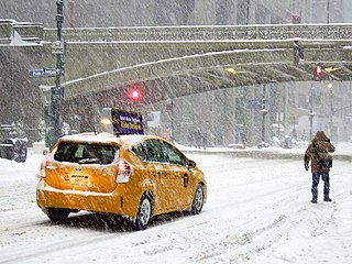
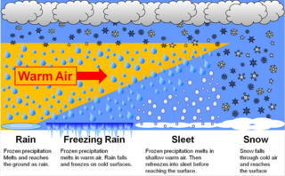
Freezing rain is rain maintained at temperatures below freezing by the ambient air mass that causes freezing on contact with surfaces. Unlike a mixture of rain and snow or ice pellets, freezing rain is made entirely of liquid droplets. The raindrops become supercooled while passing through a sub-freezing layer of air hundreds of meters above the ground, and then freeze upon impact with any surface they encounter, including the ground, trees, electrical wires, aircraft, and automobiles. The resulting ice, called glaze ice, can accumulate to a thickness of several centimeters and cover all exposed surfaces. The METAR code for freezing rain is FZRA.
A winter storm is an event in which wind coincides with varieties of precipitation that only occur at freezing temperatures, such as snow, mixed snow and rain, or freezing rain. In temperate continental and subarctic climates, these storms are not necessarily restricted to the winter season, but may occur in the late autumn and early spring as well. A snowstorm with strong winds and other conditions meeting certain criteria is called a blizzard.

In meteorology, precipitation is any product of the condensation of atmospheric water vapor that falls from clouds due to gravitational pull. The main forms of precipitation include drizzle, rain, sleet, snow, ice pellets, graupel and hail. Precipitation occurs when a portion of the atmosphere becomes saturated with water vapor, so that the water condenses and "precipitates" or falls. Thus, fog and mist are not precipitation; their water vapor does not condense sufficiently to precipitate, so fog and mist do not fall. Two processes, possibly acting together, can lead to air becoming saturated with water vapor: cooling the air or adding water vapor to the air. Precipitation forms as smaller droplets coalesce via collision with other rain drops or ice crystals within a cloud. Short, intense periods of rain in scattered locations are called showers.

A dirt cone is a type of depositional glacial feature. Dirt cones are not actually made entirely of dirt. They have a core of ice, snow, or firn that gets covered with material and insulated. The material, if it is thick enough, will protect the underlying core from ablation. The thickness of material needed to insulate the core is called the “critical thickness.” If the material is less thick than the critical thickness, it will actually speed up erosion of the core through ablation. This is called “indirect ablation.” The cone would then begin melting and shrinking away.
A winter storm warning is a hazardous weather statement issued by Weather Forecast Offices (WFO) of the National Weather Service (NWS) in the United States to alert the public that a winter storm is occurring or is about to occur in the area, usually within 36 hours of the storm's onset.
A winter weather advisory is a hazardous weather statement issued by local Weather Forecast Offices (WFO) of the National Weather Service in the United States when one or more types of winter precipitation—snow, rain and snow mixed, freezing rain, sleet, graupel, etc.—presenting a hazard, but not expected to produce accumulations meeting storm warning criteria, are forecast within 36 hours of the expected onset of precipitation or are occurring in the advisory's coverage area.
Ice pellets or sleet is a form of precipitation consisting of small, hard, translucent balls of ice. Ice pellets are different from graupel, which is made of frosty white opaque rime, and from a mixture of rain and snow, which is a slushy liquid or semisolid. Ice pellets often bounce when they hit the ground or other solid objects, and make a higher-pitched "tap" when striking objects like jackets, windshields, and dried leaves, compared to the dull splat of liquid raindrops. Pellets generally do not freeze into other solid masses unless mixed with freezing rain. The METAR code for ice pellets is PL.
The Northeast snowfall impact scale (NESIS) was created to measure snowstorms in the U.S. Northeast in much the same way the Saffir–Simpson hurricane scale records hurricane intensity and the enhanced Fujita scale with tornadoes. This scale takes into account the very high population of the Northeast, and thus snowfall amounts are often smaller compared to what other areas of the USA would consider significant snowfall amounts.

Graupel, also called soft hail or snow pellets, is precipitation that forms when supercooled water droplets in air are collected and freeze on falling snowflakes, forming 2–5 mm (0.08–0.20 in) balls of crisp, opaque rime.

The October 2006 Buffalo storm was an unusual early-season lake effect snow storm that hit the Buffalo, New York, area and other surrounding areas of the United States and Canada, from the afternoon of Thursday, October 12 through the morning of Friday, October 13, 2006. It was called Lake Storm Aphid by the National Weather Service office in Buffalo, in accordance with their naming scheme for lake-effect snowstorms for that year, which related to insects, though locals never used that terminology and have simply referred to it as the October Surprise or the October Storm or Arborgeddon.

A historic snowstorm struck the Ohio Valley of the United States, as well as Ontario in Canada, on December 22 and December 23 and is not the same storm that led to snow in Texas on Christmas Eve. It lasted roughly 30 hours, and brought snowfall amounts up to 29 inches (74 cm) to portions of the Midwestern United States. Damages from the storm totaled US$900 million (2004 dollars). A total of 18 died during the storm, one from Canada, mainly due to car accidents.
The Early Winter 2006 North American storm complex was a severe winter storm that occurred on November 26, 2006, and continued into December 1. It affected much of North America in some form, producing various kinds of severe weather including a major ice storm, blizzard conditions, high winds, extreme cold, a serial derecho and some tornadoes.

It is very rare for snow to fall in the U.S. state of Florida, especially in the central and southern portions of the state. With the exception of the far northern areas of the state, most of the major cities in Florida have never recorded measurable snowfall, though trace amounts have been recorded, or flurries in the air observed few times each century. According to the National Weather Service, in the Florida Keys and Key West there is no known occurrence of snow flurries since the European colonization of the region more than 300 years ago. In Miami, Fort Lauderdale, and Palm Beach there has been only one known report of snow flurries observed in the air in more than 200 years; this occurred in January 1977. In any event, Miami, Fort Lauderdale, and Palm Beach have not seen snow flurries before or since this 1977 event.

The February 2007 North American blizzard was a massive winter storm that affected most of the eastern half of North America, starting on February 12, 2007 and peaking on Valentine's Day, February 14. The storm produced heavy snowfalls across the midwestern United States from Nebraska to Ohio and produced similar conditions across parts of the northeastern United States, and into Canada in Ontario, Quebec and New Brunswick. Significant sleet and freezing rain fell across the southern Ohio Valley and affected portions of the east coast of the United States, including the cities of Boston, Baltimore, Washington, D.C., New York City and Philadelphia.
In meteorology, the different types of precipitation often include the character, formation, or phase of the precipitation which is falling to ground level. There are three distinct ways that precipitation can occur. Convective precipitation is generally more intense, and of shorter duration, than stratiform precipitation. Orographic precipitation occurs when moist air is forced upwards over rising terrain and condenses on the slope, such as a mountain.
Rain and snow mixed or sleet is precipitation composed of a mixture of rain and partially melted snow. Unlike ice pellets, which are hard, and freezing rain, which is fluid until striking an object where it fully freezes, this precipitation is soft and translucent, but it contains some traces of ice crystals from partially fused snowflakes, also called slush. In any one location, it usually occurs briefly as a transition phase from rain to snow or vice-versa, but hits the surface before fully transforming. Its METAR code is RASN or SNRA.

Classifications of snow describe and categorize the attributes of snow-generating weather events, including the individual crystals both in the air and on the ground, and the deposited snow pack as it changes over time. Snow can be classified by describing the weather event that is producing it, the shape of its ice crystals or flakes, how it collects on the ground, and thereafter how it changes form and composition. Depending on the status of the snow in the air or on the ground, a different classification applies.

In meteorology, a trace denotes an amount of precipitation, such as rain or snow, that is greater than zero, but is too small to be measured by standard units or methods of measurement. The designation of a trace rather than zero is used to indicate that precipitation did fall, but not enough to be measured reliably. This is important for both weather forecasting and climatological purposes, because even precipitation amounts too small to be measured can have significant societal impacts.

A shower is a mode of precipitation characterized by an abrupt start and end and by rapid variations in intensity. Often strong and short-lived, it comes from convective clouds, like cumulus congestus. A shower will produce rain if the temperature is above the freezing point in the cloud, or snow / ice pellets / snow pellets / hail if the temperature is below it at some point. In a meteorological observation, such as the METAR, they are noted SH giving respectively SHRA, SHSN, SHPL, SHGS and SHGR.

The February 6–8, 2021 nor'easter, also referred to as the 2021 Super Bowl Sunday nor'easter, was a strong and fast-moving nor'easter that started out in the Southern United States, before impacting the Mid-Atlantic and New England states on Super Bowl Sunday, in February 2021. The storm struck the region just days after another significant nor'easter impacted the same general regions. Developing on February 6 along a stationary front in the Southern United States and moving northeastward, the imminent impacts from the nor'easter forced several vaccination sites in the Northeast to temporarily close again for the following days. The storm caused one indirect death, and damage estimates are currently undetermined. It was unofficially named Winter Storm Quade by The Weather Channel.