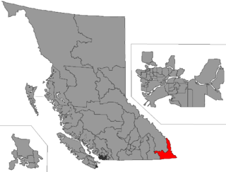
Political Geography
| | This section is empty. You can help by adding to it. (July 2010) |
Slocan was a provincial electoral district in the Canadian province of British Columbia. It made its first appearance in the election of 1903 and its last in the general election of 1920. It was succeeded by the Kaslo-Slocan riding in the 1924 election.
For other current and historical electoral districts in the Kootenay region, please see Kootenay (electoral districts).
| Population, 1901 | |
| Population Change, 1901–1921 | |
| Area (km²) | |
| Pop. Density (people per km²) |
| | This section is empty. You can help by adding to it. (July 2010) |
| | This section is empty. You can help by adding to it. (July 2010) |
| | This section is empty. You can help by adding to it. (July 2010) |
Note: Winners in each election are in bold.
| Party | Candidate | Votes | % | ± | Expenditures | |
|---|---|---|---|---|---|---|
| Labour1 | William Davidson | 358 | 55.33% | unknown | ||
| Conservative | William Hunter | 289 | 44.67% | unknown | ||
| Total valid votes | 647 | 100.00% | ||||
| Total rejected ballots | ||||||
| Turnout | % | |||||
| 1 Nominated by the Slocan Labour Party, which was based on the Provincial Progressive Party of 1902, and supported by the Socialists | ||||||
| Party | Candidate | Votes | % | ± | Expenditures | |
|---|---|---|---|---|---|---|
| Socialist | William Davidson | 119 | 30.28% | – | unknown | |
| Liberal | Archibald B. Docksteader | 81 | 20.61% | unknown | ||
| Conservative | William Hunter | 193 | 49.11% | unknown | ||
| Total valid votes | 393 | 100.00% | ||||
| Total rejected ballots | ||||||
| Turnout | % | |||||
| 1909 British Columbia general election | ||||||||
|---|---|---|---|---|---|---|---|---|
| Party | Candidate | Votes | % | |||||
| Conservative | William Hunter | 309 | 57.43 | |||||
| Socialist | John William Bennett | 172 | 31.97 | |||||
| Independent Labour | Joseph Colebrook Harris | 57 | 10.59 | |||||
| Total valid votes | 538 | 100.00 | ||||||
| Party | Candidate | Votes | % | ± | Expenditures | |
|---|---|---|---|---|---|---|
| Conservative | William Hunter | 373 | 65.32% | unknown | ||
| Socialist | Anthony Shilland | 198 | 34.68% | – | unknown | |
| Total valid votes | 571 | 100.00% | ||||
| Total rejected ballots | ||||||
| Turnout | % | |||||
| Party | Candidate | Votes | % | ± | Expenditures | |
|---|---|---|---|---|---|---|
| Conservative | William Hunter | 447 | 49.94% | unknown | ||
| Liberal | Charles Franklin Nelson | 448 | 50.06% | unknown | ||
| Total valid votes | 895 | 100.00% | ||||
| Total rejected ballots | ||||||
| Turnout | % | |||||
| Party | Candidate | Votes | % | ± | Expenditures | |
|---|---|---|---|---|---|---|
| Conservative | William Hunter | 568 | 41.55% | unknown | ||
| Liberal | Charles Franklin Nelson | 471 | 34.46% | unknown | ||
| Federated Labour Party 2 | Alfred Harvey Smith | 328 | 23.99% | unknown | ||
| Total valid votes | 1,367 | 100.00% | ||||
| Total rejected ballots | ||||||
| 76.94% | ||||||
| 2 Also referred to as "O.B.U." (One Big Union) candidate | ||||||
Elections BC historical returns

The Regional District of Central Kootenay (RDCK) is a regional district in the province of British Columbia, Canada. As of the 2016 census, the population was 59,517. The area is 22,130.72 square kilometres. The administrative centre is located in the city of Nelson. Other municipalities include the City of Castlegar, the Town of Creston, the Village of Salmo, the Village of Nakusp, the Village of Kaslo, the Village of New Denver, the Village of Silverton, the Village of Ymir and the Village of Slocan.
The Columbia and Kootenay Railway (C&KR) was a historic railway operated by the Canadian Pacific Railway (CPR) in the West Kootenay region of British Columbia. This 25-mile (40 km) route, beside the unnavigable Kootenay River, linked Nelson on the west arm of Kootenay Lake with Robson at the confluence of the Kootenay River and the Columbia River near Castlegar.

British Columbia Southern Interior was a federal electoral district in the province of British Columbia, Canada, that had been represented in the House of Commons of Canada from 1997 to 2015.

Kootenay East is a provincial electoral district for the Legislative Assembly of British Columbia, Canada. It was created before the 1966 election by the merger of Cranbrook and Fernie ridings, and despite its long period under the "Kootenay" moniker, never extended to cover more than a fraction of the whole "Kootenay" region.
West Kootenay-Slocan was an electoral district in the Canadian province of British Columbia from 1898 to 1903.
West Kootenay South was an electoral district in the Canadian province of British Columbia in the 1894 election only. Its official name was "West Kootenay ". It was formed from the division of the older Kootenay riding, one of the province's first twelve constituencies, which for the 1890 election was redistributed into:
West Kootenay North was an electoral district in the Canadian province of British Columbia in the 1894 election only. Its official name was "West Kootenay. It was formed from a partition the West Kootenay riding that also created West Kootenay.
West Kootenay was a provincial electoral district in the Canadian province of British Columbia. It was formed along with East Kootenay from a redistribution of the old Kootenay riding, which was one of the province's original twelve.
Greenwood was the name of a provincial electoral district in the Canadian province of British Columbia. It was located in there Boundary Country west of Grand Forks around the city of Greenwood. It first appeared on the hustings in the large redistribution prior to the 1903 election. For the 1924 election it was merged with the Grand Forks riding to form Grand Forks-Greenwood.

Boundary-Similkameen is a provincial riding formed in 2008. It includes the populations of Penticton-Okanagan Valley, West Kootenay-Boundary and Yale-Lillooet. The riding's name corresponds to that of a former riding in the same area, with similar but not identical boundaries.
Kaslo was a provincial electoral district in the Canadian province of British Columbia. It made its first appearance in the election of 1903 and its last in the general election of 1920. It was succeeded by the Kaslo-Slocan riding in the 1924 election.
Kaslo-Slocan was the name of a provincial electoral district in the Canadian province of British Columbia centred on the town of Kaslo on Kootenay Lake as well as the mining towns of the "Silvery Slocan". The riding first appeared in the 1924 election as the result of a merger of the former ridings of Kaslo and Slocan, and lasted until the 1963 election.
Fernie was the name of a provincial electoral district in the Canadian province of British Columbia centred on the town of Fernie in the southern Rockies. It made its first appearance on the hustings in the election of 1903. In a redistribution after the 1963 election the area covered by this riding was incorporated into the new Kootenay riding.
Cranbrook was the name of a provincial electoral district in the Canadian province of British Columbia centred on the town of Cranbrook in the southern Rockies and including nearby Kimberley and other towns in the southern end of the Rocky Mountain Trench.
Revelstoke-Slocan was the name of a provincial electoral district in the Canadian province of British Columbia from 1966 to 1986. The riding was formed from a merger of the Revelstoke riding with the Slocan riding. The successor riding in this region is the current Columbia River-Revelstoke riding.
Shuswap-Revelstoke was a provincial electoral district in the Canadian province of British Columbia from 1979 to 1991. The riding was formed by merging the northern portions of the Revelstoke-Slocan riding with the Shuswap riding. The successor riding for the Revelstoke area is the current Columbia River-Revelstoke riding.
Revelstoke was a provincial electoral district in the Canadian province of British Columbia. It made its first appearance on the hustings in the election of 1903 and lasted until the 1928 election,
West Kootenay Transit System is the public transit system in Trail, Castlegar, Nelson, British Columbia and surrounding area. The transit services are operated from Trail, Castlegar, Nelson and serve Rossland, Warfield, Genelle, Montrose, Fruitvale, Salmo, Kaslo, Creston, Nakusp. Funding is provided under a partnership between the Regional District of Kootenay Boundary, Regional District of Central Kootenay and BC Transit. handyDART provides door-to-door transportation for people whose disability prevents them from using conventional bus service.
Slocan may refer to: