Remick Ridge Vineyards is a California-based vineyard and winery owned and operated by the Smothers Brothers. It is a monopole vineyard for Arrowood Vineyards and Winery in the Sonoma Valley. The setting of this viticulture operation is on a ridge of the northern Sonoma Mountains above Sonoma Creek. The name Remick is the maiden name of the brothers' mother. It was established in 1977.
Sears Point is a prominent landform that juts into the San Pablo Bay in Sonoma County, California, United States. This hill is the southernmost peak of the Sonoma Mountains and forms the southwestern ridge above Tolay Lake. Starting with European settlement of this area in the mid-19th century considerable modification of the Napa Sonoma Marsh began to occur, such that in contemporary times, there is considerable upland between Sears Point and San Pablo Bay. Numerous local conservation organizations are presently working to restore hundreds of acres of these historic tidal wetlands as part of the Sears Point Wetlands and Watershed Restoration Project. The region can be accessed via State Route 37 or State Route 121.
The Cotati-Rohnert Park Unified School District (CRPUSD) is a school district in Sonoma County, California.

Sonoma Mountain Zen Center is a Soto Zen practice center located on 80 acres (30 ha) in the mountainous region of Sonoma County in California—near Santa Rosa—carrying on the tradition and lineage of Shunryu Suzuki. Founded by Jakusho Kwong and his wife Laura Kwong in 1973, Kwong-roshi is the current guiding teacher of the Zen center. Offering residential training, Saturday Community and group retreats. Sonoma Mountain Zen Center also offers a practice regimen for members of the surrounding area and elsewhere who are not residents.

The Fairfield Osborn Preserve is a 450-acre nature reserve situated on the northwest flank of Sonoma Mountain in Sonoma County, California. There are eight plant communities within the property, oak woodland being the dominant type. Other communities include chaparral, Douglas fir woodland, native Bunch grass, freshwater marsh, vernal pool, pond and riparian woodland. The flora is extremely diverse including many native trees, shrubs, wildflowers, grasses, lichens and mosses. A diverse fauna inhabits this area including black-tailed deer, coyote, bobcat and an occasional mountain lion; moreover, there are abundant avifauna, amphibians, reptiles and insects.

The Healdsburg Fault is a seismically active geological feature associated with the Santa Rosa Plain and the Alexander Valley, in Sonoma County, California, United States. The eastern sides of these floodplains are bounded by strike-slip or transform faults. The maximum credible earthquake expected to be generated from the Healdsburg Fault is estimated to be about 7.5 on the Richter magnitude scale.
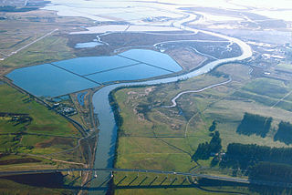
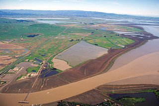
The Napa Sonoma Marsh is a wetland at the northern edge of San Pablo Bay, which is a northern arm of the San Francisco Bay in California, United States. This marsh has an area of 48,000 acres (190 km2), of which 13,000 acres (53 km2) are abandoned salt evaporation ponds. The United States Government has designated 13,000 acres (53 km2) in the Napa Sonoma Marsh as the San Pablo Bay National Wildlife Refuge.
The Van Hoosear Wildflower Preserve is a private nature reserve on Carriger Creek in southern Sonoma County, California, United States. Van Hoosear was created to preserve an area known for displays of native wildflowers and to allow animal migration and ecological connection between Sonoma Mountain and the floor of the Sonoma Valley. This 163-acre (66 ha) preserve has been established with an endowment fund to allow perpetual management; access to the preserve is controlled by the Sonoma Ecology Center.
Tomales High School is located in the town of Tomales, California, United States. It is the comprehensive high school of the Shoreline Unified School District. It serves the western Marin and Sonoma County communities, stretching from the towns of Point Reyes Station and Inverness along Tomales Bay, running north past the fishing port of Bodega Bay to the mouth of the Russian River, a distance of nearly 50 miles (80 km), and widening 13 miles (21 km) east from the west coast. Tomales High School draws its students from approximately 450 square miles (1,200 km2). Tomales High School was recognized as a California Distinguished School in 2011.
The Bennett Valley AVA is an American Viticultural Area located in Sonoma County, California. The boundaries of this appellation lie completely within the North Coast AVA, almost completely within the Sonoma Valley AVA and overlaps into some areas of the Sonoma Coast AVA and Sonoma Mountain AVA. The region was granted AVA status on December 23, 2003 following the petition of Matanzas Creek Winery. The AVA is surrounded to the south, east and west by the Sonoma Mountains and to the north by the city of Santa Rosa, California. The region receives a moderating effect on its climate from Pacific Ocean through the cool coastal fogs and breeze that creep into the area from the southwest through Crane Canyon between Sonoma Mountain and Taylor Mountain. Barbera, Cabernet Sauvignon, Cabernet Franc, Chardonnay, Grenache, Merlot, Pinot noir, Sauvignon blanc and Syrah are the leading grape varieties planted.
The Sonoma Mountain AVA is an American Viticultural Area in Sonoma County, California, United States. It is centered on the Sonoma Mountain landform in the Sonoma Mountains. The appellation includes the town of Glen Ellen, California and is nearly surrounded by the Sonoma Valley AVA. The area is known for the diverse micro-climates that occur on exposed hillsides and shaded drainages, and as such is home to production for a wide range of varieties including Cabernet Sauvignon, Chardonnay, Pinot noir, Sauvignon blanc, Semillon, and Zinfandel.

The Sonoma Valley AVA is an American Viticultural Area in Sonoma County, California which centers on the Sonoma Valley in the southern portion of the county. The name 'Sonoma' means 'Valley of the Moon' in the local Native American dialect. The appellation is bordered by two mountain ranges: the Mayacamas Mountains to the east and the Sonoma Mountains to the west.

The Dry Creek Rancheria is the land base (reservation) of the Dry Creek Rancheria Band of Pomo Indians. The reservation consists today of approximately 75 acres (300,000 m2) near the Russian River, in Sonoma County, approximately 75 miles (121 km) north of San Francisco, California. It is situated about 3 miles southeast of Geyserville.
Gundlach Bundschu Winery is a historic winery and an outdoor concert venue located in Sonoma County. It is California's oldest continuously family-owned winery, and is the second oldest winery after Buena Vista Winery. It is still owned and operated by the founder's heirs and today led by the sixth generation, Jeff Bundschu. The winery's 320-acre (130 ha) organic estate vineyard, named Rhinefarm by Bavarian-born Jacob Gundlach in 1858, is located within the Sonoma Valley AVA of Sonoma County, at the crossroads of the Sonoma Valley, Los Carneros AVA and Napa Valley AVA, along the Mayacamas Mountains. They specialize in estate-driven, organically farmed Bordeaux reds and cool climate varietal wines.
Sonoma International Film Festival (SIFF) is a 501 (c)(3) non-profit arts organization, founded in 1997, headquartered in Sonoma, California.

SOMO Village is a mixed-use redevelopment of a former Agilent campus in Rohnert Park, California. SOMO Village spans 200 acres in the foothills of Sonoma Mountain in Rohnert Park, California.
Socrates Mountain is a summit in Pendleton County, West Virginia, in the United States. With an elevation of 3,386 feet (1,032 m), Socrates Mountain is the 219th highest summit in the state of West Virginia.

Little Island is a partially submerged marsh island in the Napa Slough, branching off from the Napa River upstream of San Pablo Bay. It is almost entirely in Napa County, California, although part of its southern tip is in Solano County; it is managed as part of the Napa-Sonoma Marshes Wildlife Area. Its coordinates are 38°10′48″N122°21′05″W, and the United States Geological Survey measured its elevation as 3 ft (0.91 m) in 1981.

Island No. 1 is a partially submerged island in the Napa River, upstream of San Pablo Bay. It is in Napa and Solano County, California, and parts of it are managed as part of the Napa-Sonoma Marshes Wildlife Area. Its coordinates are 38°08′35″N122°20′40″W, and the United States Geological Survey measured its elevation as 3 ft (0.91 m) in 1981. It, along with Island No. 2, Green Island and Tubbs Island, are labeled on a 1902 USGS map of the area.

Knight Island is a mostly-submerged island in the Napa River, upstream of San Pablo Bay. It is in Solano County, California, and managed as part of the Napa-Sonoma Marshes Wildlife Area. Its coordinates are 38°08′09″N122°17′58″W, and the United States Geological Survey measured its elevation as 3 ft (0.91 m) in 1981.