External links
| | This Italian location article is a stub. You can help Wikipedia by expanding it. |
| | This trail or long-distance path-related article is a stub. You can help Wikipedia by expanding it. |
The Sorgenti di Firenze Trekking (SOFT, Florence Springs Walking) is a system of hiking trails with twenty-two secondary trails that are connected to it in Tuscany.
In the valley of the Mugello, you can walk for days along the Apennines Florentine.
In the course of the first ring, walkers can be housed in "places step" where there are public shelters in villas, farmhouses, former country schools, monasteries, camping or travel companies. The stopping place is almost always in small villages or in places attractive, accessible by car.
The twenty-two secondary routes offer the possibility of a days-on-end of hiking, each highlighting a particular theme of environmental, historical and artistic routes.
| | This Italian location article is a stub. You can help Wikipedia by expanding it. |
| | This trail or long-distance path-related article is a stub. You can help Wikipedia by expanding it. |

The Lycian Way is a marked long-distance hiking trail in southwestern Turkey around part of the coast of ancient Lycia. It is approximately 520 km (320 mi) in length and stretches from Hisarönü (Ovacık), near Fethiye, to Aşağı Karaman in Konyaaltı, about 20 km (12 mi) from Antalya. It is waymarked with red and white stripes of the GR footpath convention.

Hiking is a long, vigorous walk, usually on trails or footpaths in the countryside. Walking for pleasure developed in Europe during the eighteenth century. Religious pilgrimages have existed much longer but they involve walking long distances for a spiritual purpose associated with specific religions.
The Pacific Crest Trail (PCT), officially designated as the Pacific Crest National Scenic Trail, is a long-distance hiking and equestrian trail closely aligned with the highest portion of the Cascade and Sierra Nevada mountain ranges, which lie 100 to 150 miles east of the U.S. Pacific coast. The trail's southern terminus is next to the Mexico–United States border, just south of Campo, California, and its northern terminus is on the Canada–US border, upon which it continues unofficially to the Windy Joe Trail within Manning Park in British Columbia; it passes through the states of California, Oregon, and Washington.

Landmannalaugar is a location in Iceland's Fjallabak Nature Reserve in the Highlands. It is on the edge of the Laugahraun lava field. This lava field was formed by an eruption in approximately 1477. It is largely known for its natural geothermal hot springs and surrounding landscape.
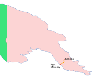
The Kokoda Track or Trail is a single-file foot thoroughfare that runs 96 kilometres (60 mi) overland – 60 kilometres (37 mi) in a straight line – through the Owen Stanley Range in Papua New Guinea (PNG). The track was the location of the 1942 World War II battle between Japanese and Allied – primarily Australian – forces in what was then the Australian territory of Papua.

Laugavegur is a hiking trail in South Iceland. It is the most popular trail in Iceland, with an estimated 75,000-100,000 people hiking it every year. In 2012, National Geographic listed it as one of the twenty best trails in the world.

The Oregon Coast Trail (OCT) is a long-distance hiking route along the Pacific coast of the U.S. state of Oregon in the United States. It follows the coast of Oregon from the mouth of the Columbia River to the California border south of Brookings.
The Colorado Trail is a long-distance trail running for 486 miles (782 km) from the mouth of Waterton Canyon southwest of Denver to Durango in Colorado, United States. Its highest point is 13,271 feet (4,045 m) above sea level, and most of the trail is above 10,000 feet (3,000 m). Despite its high elevation, the trail often dips below the alpine timberline to provide refuge from the exposed, storm-prone regions above.
Trekking poles are a common hiking accessory that function to assist walkers with their rhythm, to provide stability, and reduce strain on joints on rough terrain.

Helambu is a region of highland villages in Nepal, about 80 km from Kathmandu. It is the home of the Hyolmo people. The word Hyolmo derives from the word Helambu. The Helambu region begins at the Lauribina La pass and descends to the Melamchi valley. Helambu is famous for its sweet apples. and artistic Buddhist monasteries and it is a Buddhist pilgrimage site.

John Harvey Butchart was a mathematics professor who was well known for his hiking exploits in and around the Grand Canyon in Arizona, United States. Beginning in 1945, Butchart explored the Grand Canyon's backcountry on foot. He wrote extensively about his adventures and influenced generations of canyoneers.

The Lares trek is a two- or three-day high-altitude hike in Cusco, Peru, starting near the village Lares, approximately 40 mi (64 km) north of Cusco and 35 mi (56 km) east of Machu Picchu. The Lares Valley lies in the east of the Urubamba mountain range, traversing part of the Sacred Valley. Reaching the start of the trek requires a bus or van trip of approximately five hours from the village of Lares. The trek route transverses typical Peruvian Andean mountain areas.

Outdoor recreation or outdoor activity refers to recreation done outside, most commonly in natural settings. The activities that encompass outdoor recreation vary depending on the physical environment they are being carried out in. These activities can include fishing, hunting, backpacking, walking and horseback riding — and can be completed individually or collectively. Outdoor recreation is a broad concept that encompasses a varying range of activities and landscapes.

A long-distance trail is a longer recreational trail mainly through rural areas used for hiking, backpacking, cycling, horse riding or cross-country skiing. They exist on all continents except Antarctica.

The Inca Trail to Machu Picchu is a hiking trail in Peru that terminates at Machu Picchu. It consists of three overlapping trails: Mollepata, Classic, and One Day. Mollepata is the longest of the three routes with the highest mountain pass and intersects with the Classic route before crossing Warmiwañusqa. Located in the Andes mountain range, the trail passes through several types of Andean environments including cloud forest and alpine tundra. Settlements, tunnels, and many Incan ruins are located along the trail before ending the terminus at the Sun Gate on Machu Picchu mountain. The two longer routes require an ascent to beyond 4,200 metres (13,800 ft) above sea level, which can result in altitude sickness.

The Triple Crown of Hiking refers to the three major U.S. long-distance hiking trails:

The Great Himalaya Trail is a route across the Himalayas from east to west. The original concept was to establish a single long distance trekking trail from the east end to the west end of Nepal that includes a total of roughly 1,700 kilometres (1,100 mi) of path. There is a proposed trail of more than 4,500 kilometres (2,800 mi) stretching the length of the Greater Himalaya range from Nanga Parbat in Pakistan to Namche Barwa in Tibet thus passing through, India, Nepal, Bhutan and Tibet. Although an actual continuous route is currently only a concept, if completed it would be the longest and highest alpine hiking track in the world.

The Annapurna Circuit is a trek within the mountain ranges of central Nepal. The total length of the route varies between 160–230 km, depending on where motor transportation is used and where the trek is ended. This trek crosses two different river valleys and encircles the Annapurna Massif. The path reaches its highest point at Thorung La pass, reaching the edge of the Tibetan plateau. Most trekkers hike the route anticlockwise, as this way the daily altitude gain is slower, and crossing the high Thorong La pass is easier and safer.

The Arctic Circle Trail is a hiking trail in Greenland. The route covers 165 kilometres (103 mi) from the interior settlement of Kangerlussuaq to Sisimiut on the coast.