
Aoraki / Mount Cook is the highest mountain in New Zealand. Its height, as of 2014, is listed as 3,724 metres. It sits in the Southern Alps, the mountain range that runs the length of the South Island. A popular tourist destination, it is also a favourite challenge for mountain climbers. Aoraki / Mount Cook consists of three summits: from south to north, the Low Peak, the Middle Peak and the High Peak. The summits lie slightly south and east of the main divide of the Southern Alps, with the Tasman Glacier to the east and the Hooker Glacier to the southwest. Mount Cook is ranked 10th in the world by topographic isolation.

Riverton, officially Riverton / Aparima, is a small New Zealand town 30 kilometres (19 mi) west of Invercargill, on the south-eastern shorelines of the Jacobs River Estuary. The estuary is formed by the Aparima and Pourakino rivers, leading through a narrow outflow channel into Foveaux Strait. Accessible via State Highway 99 on the Southern Scenic Route, the main part of the town is on flat land and the northern end of Oreti Beach. South Riverton is built on the hills between the eastern shore of the estuary and Taramea Bay.
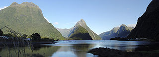
Milford Sound is a fiord in the south west of New Zealand's South Island within Fiordland National Park, Piopiotahi Marine Reserve, and the Te Wahipounamu World Heritage site. It has been judged the world's top travel destination in an international survey and is acclaimed as New Zealand's most famous tourist destination. Rudyard Kipling called it the eighth Wonder of the World. The fiord is most commonly accessed via road by tour coach, with the road terminating at a small village also called Milford Sound.
Ngāi Tahu, or Kāi Tahu, is the principal Māori iwi (tribe) of the South Island. Its takiwā is the largest in New Zealand, and extends from the White Bluffs / Te Parinui o Whiti, Mount Mahanga and Kahurangi Point in the north to Stewart Island / Rakiura in the south. The takiwā comprises 18 rūnanga corresponding to traditional settlements. According to the 2018 census an estimated 74,082 people affiliated with the Kāi Tahu iwi.
Lake McKerrow lies at the northern end of Fiordland, in the southwest of New Zealand's South Island. The lake runs from southeast to northwest, is 15 kilometres (9 mi) in length, and covers 28 km2 (11 sq mi).

Cape Campbell, Te Rae-o-te-kōhaka in the Māori language, is in Marlborough, New Zealand, on the northeastern coast of the South Island. It lies at the southern end of Clifford Bay, 15 kilometres (9 mi) northeast of Ward, and 42 kilometres (26 mi) southeast of Blenheim. Cape Campbell lies close to the salt works at Lake Grassmere.
Waitaha, an early Māori iwi, inhabited the South Island of New Zealand. They were largely absorbed via marriage and conquest – first by the Ngāti Māmoe and then by Ngāi Tahu – from the 16th century onward. Today those of Waitaha descent are represented by the Ngāi Tahu iwi. Like Ngāi Tahu today, Waitaha was itself a collection of various ancient iwi. Kāti Rākai was said to be one of Waitaha's hapū.
Tākitimu was a waka (canoe) with whakapapa throughout the Pacific particularly with Samoa, the Cook Islands, and New Zealand in ancient times. In several Māori traditions, the Tākitimu was one of the great Māori migration ships that brought Polynesian migrants to New Zealand from Hawaiki. The canoe was said to have been captained by Tamatea.

Lyttelton Harbour / Whakaraupō is a major inlet on the northwest side of Banks Peninsula, on the coast of Canterbury, New Zealand; the other major inlet is Akaroa Harbour, which enters from the southern side of the peninsula. Whakaraupō enters from the northern coast of the peninsula, heading in a predominantly westerly direction for approximately 15 km (9.3 mi) from its mouth to the aptly-named Head of the Bay near Teddington. The harbour sits in an eroded caldera of the ancient Banks Peninsula Volcano, the steep sides of which form the Port Hills on its northern shore.

The Ōnawe Peninsula is a volcanic plug inside Akaroa Harbour, on Banks Peninsula in Canterbury, New Zealand. It is the site of a former pā. It is part of the Banks Peninsula Volcano.

The Jacobs River or Makawhio River is located some 30 km (19 mi) south of Fox Glacier in South Westland, New Zealand. From its headwaters near Fettes Peak below the Hooker Range it flows in a westerly direction to enter the Tasman Sea near Hunts Beach. Its tributaries include Jumbo Creek and Pavo Creek. Just upstream from the bridge is Borat Flat.
The Otago region of New Zealand is one of the more isolated places of the inhabited earth. Its high latitude, elevation and distance from larger foreign and domestic population centres have defined Otago at each stage of its history.
Uruaokapuarangi was one of the great ocean-going, voyaging canoes that was used in the migrations that settled the South Island according to Māori tradition.
Port Pegasus, officially Port Pegasus / Pikihatiti, is at the southern end of Stewart Island in New Zealand. From the 1890s to the 1950s, Port Pegasus was the site of a small fishing community. There was also a small tin-mining boom in the area in the 1890s. Today, there is no settlement at Port Pegasus, but the location is frequented by tourists, fishermen, hunters, and divers.
Mount Watkin/Hikaroroa is a 616-metre peak located north-west of Waikouaiti, Otago, New Zealand. It is on the east side of the North Branch of the Waikouaiti River.
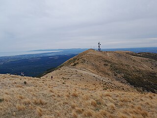
Mount Grey is a 934-metre (3,065 ft) mountain 15 kilometres west of Amberley in New Zealand. It is named after Sir George Grey who was governor of New Zealand when English surveyors climbed it in 1849. In Te Reo Māori, the mountain is called Maukatere, 'floating mountain', from where the spirits of the dead leave on the long journey to Cape Reinga.

The Ngāi Tahu Claims Settlement Act 1998 is an act of Parliament passed in New Zealand relating to Ngāi Tahu, the principal Māori iwi (tribe) of Te Waipounamu the South Island. It was negotiated in part by Henare Rakiihia Tau. The documents in relation to the Ngāi Tahu land settlement claim are held at Tūranga, the main public library in Ōtautahi Christchurch.
Whareakeake is a beach 25 kilometres (16 mi) northeast of Dunedin in the South Island of New Zealand, as well as the valley above and behind the beach. Located to the west of Aramoana and included as a section of the Otago Heads, Whareakeake was a place of habitation for Māori people from early times until the Sealers' War skirmish of 1817 from which it derived its colonial name. It is now a surfing beach renowned for its right-hand point break.

Coopers Lagoon / Muriwai is a small coastal waituna-type lagoon in the Canterbury region of New Zealand, located approximately halfway between the mouth of the Rakaia River and the outlet of the much larger Lake Ellesmere / Te Waihora. While the present-day lagoon is separated from the nearby Canterbury Bight by approximately 100 metres (330 ft), the water of the lagoon is considered brackish and early survey maps show that, until recently, the lagoon was connected to the ocean by a small channel. The lagoon, along with the surrounding wetlands, has historically been an important mahinga kai for local Māori.
The Greenstone River / Hokonui, also known as the Big Hohonu River, is a river on the West Coast of New Zealand's South Island. It rises in the Hohonu Range, an outlying range of the Southern Alps / Kā Tiritiri o te Moana, roughly 30 kilometres (19 mi) southeast of Greymouth. The river flows northwest for its entire length, eventually joining the same river valley as the larger Taramakau River near the town of Kumara. From here, the two rivers flow roughly parallel for around 5 kilometres (3.1 mi) before the Greenstone / Hokonui joins the Taramakau just shy of the latter's mouth in the Tasman Sea. The area surrounding the river was historically home to gold mining operations, following the discovery of payable amounts of gold in 1864. The township of Greenstone was established on the river in the wake of this discovery, with other industries including a sawmill soon being established.

