
Suriname or Surinam, officially known as the Republic of Suriname, is a country on the northeastern Atlantic coast of South America. It is bordered by the Atlantic Ocean to the north, French Guiana to the east, Guyana to the west and Brazil to the south. At just under 165,000 square kilometers, it is the smallest sovereign state in South America. Suriname has a population of approximately 575,990, most of whom live on the country's north coast, in and around the capital and largest city, Paramaribo.

The Republic of Suriname has a number of forms of transport. Transportation emissions are an increasing part of Suriname's contributions to climate change, as part of the Nationally Determined Contributions for the Paris Agreement, Suriname has committed to emissions controls for vehicles and increased public transit investment.
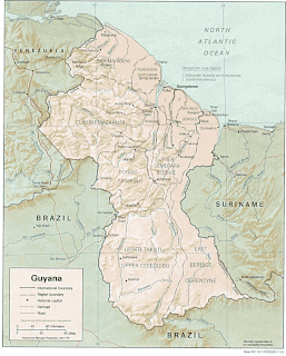
The Geography of Guyana comprises the physical characteristics of the country in Northern South America and part of Caribbean South America, bordering the North Atlantic Ocean, between Suriname and Venezuela, with a land area of approximately 214,969 square kilometres. The country is situated between 1 and 9 north latitude and between 56 and 62 west longitude. With a 459 km (285 mi)-long Atlantic coastline on the northeast, Guyana is bounded by Venezuela on the west, Brazil on the west and south, and Suriname on the east. The land comprises three main geographical zones: the coastal plain, the white sand belt and the interior highlands.

Paramaribo is the capital and largest city of Suriname, located on the banks of the Suriname River in the Paramaribo District. Paramaribo has a population of roughly 241,000 people, almost half of Suriname's population. The historic inner city of Paramaribo has been a UNESCO World Heritage Site since 2002.

A drainage basin is any area of land where precipitation collects and drains off into a common outlet, such as into a river, bay, or other body of water. The drainage basin includes all the surface water from rain runoff, snowmelt, hail, sleet and nearby streams that run downslope towards the shared outlet, as well as the groundwater underneath the earth's surface. Drainage basins connect into other drainage basins at lower elevations in a hierarchical pattern, with smaller sub-drainage basins, which in turn drain into another common outlet.

Nickerie is a district of Suriname, on the north-west coast. Nickerie's capital city is Nieuw-Nickerie. Another town is Wageningen. The district borders the Atlantic Ocean to the north, the Surinamese district of Coronie to the east, the Surinamese district of Sipaliwini to the south and Guyana to the west.
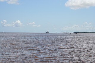
Corriverton is the most easterly town in Guyana. It lies at the mouth of the Corentyne River, opposite Nieuw Nickerie, Suriname, to which it is linked by ferry from South Drain.
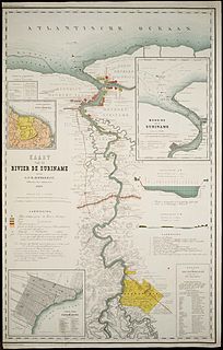
The Suriname River is 480 km long and flows through the country Suriname. Its sources are located in the Guiana Highlands on the border between the Wilhelmina Mountains and the Eilerts de Haan Mountains. The river flows below the reservoir along Brokopondo, Berg en Dal, the migrant communities Klaaskreek and Nieuw-Lombé, Jodensavanne, Carolina, Ornamibo and Domburg, before reaching the capital Paramaribo on the left bank and Meerzorg on the right bank. At Nieuw-Amsterdam it is joined by the Commewijne and immediately thereafter at the sandspit Braamspunt it flows into the Atlantic Ocean.

The Coppename is a river in Suriname in the district of Sipaliwini, forming part of the boundary between the districts of Coronie and Saramacca.
Moleson Creek is a community on the Corentyne River in the East Berbice-Corentyne region of Guyana, and home to the Guyana-Suriname ferry stelling. It is north of Orealla Mission, 10 km (6.2 mi) south of Corriverton, and approximately 90 km (56 mi) from New Amsterdam.
Westelijke Polders is a resort in Suriname, located in the Nickerie District. Its population at the 2012 census was 8,616. Its Dutch place name reflects Suriname's colonial past. Its western boundary is the Courantyne River, between Suriname and Guyana.

Kabalebo is a resort in Suriname, located in the Sipaliwini District. Its population at the 2012 census was 2,291.
The (northern) East-West Link is a road in Suriname between Albina in the eastern part of the country to Nieuw Nickerie in the western part, via the capital city of Paramaribo. The southern East-West Link connects Paramaribo with Apoera via Bitagron. Construction of the road link started in the 1960s.

South Drain, also Zuiddrain, is a town in western Suriname. Since the pavement of 32 kilometres (20 mi) road section to Nieuw Nickerie, it is the final destination of the northern East-West Link. The European Union funded the reconstruction, which started in 2007, with 13.2 million euro. The section was opened on 30 April 2010. There is a jeep trail between South Drain and Apoera, connecting the Northern East-West Link with the Southern East-West Link. Contrary to earlier plans, the pavement of this road is not imminent.
Transvaal is a historical geographic term associated with land north of the Vaal River in South Africa. A number of states and administrative divisions have carried the name Transvaal.
The Berbice Bridge is a pontoon bridge over the Berbice River near New Amsterdam in Guyana. The bridge is tolled and was opened on 23 December 2008.
Dutch Guiana may refer to:
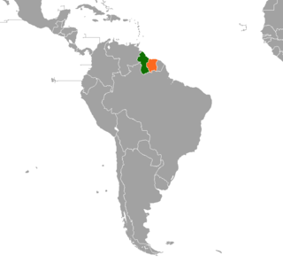
Guyana – Suriname relations refer to the bilateral relations between Guyana and Suriname. Suriname has an embassy in Georgetown. Guyana has an embassy in Paramaribo. The Courantyne River makes up most of the border between the two countries.

The COVID-19 pandemic in Suriname is part of the worldwide pandemic of coronavirus disease 2019 caused by severe acute respiratory syndrome coronavirus 2. The virus was confirmed to have reached Suriname on 13 March 2020. The case was a person who travelled from the Netherlands the previous week. On 3 April 2020, one person died. On 3 May 2020, all nine cases had recovered. On 18 May, an eleventh case was identified.