This page is based on this
Wikipedia article Text is available under the
CC BY-SA 4.0 license; additional terms may apply.
Images, videos and audio are available under their respective licenses.

The Peace River is a 1,923-kilometre-long (1,195 mi) river in Canada that originates in the Rocky Mountains of northern British Columbia and flows to the northeast through northern Alberta. The Peace River joins the Athabasca River in the Peace-Athabasca Delta to form the Slave River, a tributary of the Mackenzie River. The Finlay River, the main headwater of the Peace River, is regarded as the ultimate source of the Mackenzie River. The combined Finlay–Peace–Slave–Mackenzie river system is the 13th longest river system in the world.

Peace River, originally named Peace River Crossing, and known as Rivière-la-Paix in French, is a town in northwestern Alberta, Canada, situated along the banks of the Peace River, at its confluence with the Smoky River, the Heart River and Pat's Creek. It is located 486 kilometres (302 mi) northwest of Edmonton, and 198 kilometres (123 mi) northeast of Grande Prairie, along Highway 2. It was known as the Village of Peace River Crossing between 1914 and 1916.

Exshaw is a hamlet in Alberta, Canada within Municipal District (M.D.) of Bighorn No. 8. Located approximately 90 kilometres (56 mi) west of downtown Calgary and 15 kilometres (9.3 mi) east of Canmore, Exshaw is situated within the Bow River valley north of the Bow River.

Heart Mountain is a mountain located in the Bow River valley just south of Exshaw, Alberta. The peak was named in 1957 for the heart shaped layer of limestone near the top.

Alberta Provincial Highway No. 2, commonly referred to as Highway 2 or the Queen Elizabeth II Highway, is a major highway in Alberta, Canada that stretches from the Canada–United States border through Calgary and Edmonton to Grande Prairie. Running primarily north to south for approximately 1,273 kilometres (791 mi), it is the longest and busiest highway in the province carrying nearly 170,000 vehicles per day in central Calgary. Between Edmonton and Fort Macleod, the highway forms a portion of Alberta's Export Highway and the CANAMEX Corridor. More than half of Alberta's 4 million residents live in the Calgary–Edmonton Corridor created by Highway 2.

Bonnie Doon is a neighbourhood in south-central Edmonton, Alberta, Canada. The western part of Bonnie Doon was a part of the City of Strathcona, starting in 1907 and became a part of Edmonton when Strathcona and Edmonton merged in 1912. The rest of the land in the neighbourhood was annexed by Edmonton the following year.

Alberta Provincial Highway No. 10, commonly referred to as Highway 10, is a 22 km (14 mi) highway in southern Alberta, Canada that forms a part of Hoo Doo Trail. It is located wholly within the Town of Drumheller as a result of the former City of Drumheller's amalgamation with the Municipal District of Badlands No. 7 on January 1, 1998. It begins at Highway 9 in the heart of Drumheller and extends southeast along the Red Deer River where it passes through Rosedale, then crosses Highway 56 and travels through East Coulee. It ends by splitting off into Highways 570, 564, and 569.

Nampa is a village in Northern Alberta located 27 km south of the Town of Peace River, along Highway 2. Heart River crosses the Highway 2 just north of community. Canadian National Railway owned railway traverses the village.

The Hay River is a large river in northern Alberta and southern Northwest Territories, Canada.

The Smoky River is a river in western Alberta, Canada. It is a major tributary of the Peace River. The descriptive name refers to the presence of "smouldering beds of coal in the riverbank" noted by the Cree Indians.

Beaver River is a large river in east-central Alberta and central Saskatchewan, Canada. It flows east through Alberta and Saskatchewan and then turns sharply north to flow into Lac Île-à-la-Crosse on the Churchill River which flows into Hudson Bay. The Alberta part is in the Cold Lake oil sands.

The Lesser Slave River is a river in central Alberta, Canada. It is a major tributary of the Athabasca River.

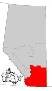
Southern Alberta is a region located in the Canadian province of Alberta. In 2004, the region's population was approximately 272,017. The primary cities are Lethbridge and Medicine Hat. The region is known mostly for agricultural production, but other sectors, such as alternative energy, film production and tourism, are emerging.

Central Alberta is a region located in the Canadian province of Alberta.

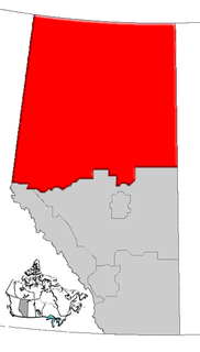
Northern Alberta is a region located in the Canadian province of Alberta.

The Smoky Group is a stratigraphical unit of Late Cretaceous age in the Western Canadian Sedimentary Basin.

The Heart River is a river in northern Alberta, Canada. It is a major tributary of the Peace River.
Heart River may refer to:


