South Shore (Lake Superior)

Last updated

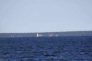
The South Shore of Lake Superior stretches from Superior, Wisconsin, United States, at the southwestern end of the lake along the Upper Peninsula of Michigan to Sault Ste Marie, Michigan, United States, in the east.

Lake Superior largest of the Great Lakes of North America

Lake Superior, the largest of the Great Lakes of North America, is also the world's largest freshwater lake by surface area, and the third largest freshwater lake by volume. The lake is shared by the Canadian province of Ontario to the north, the U.S. state of Minnesota to the west, and Wisconsin and the Upper Peninsula of Michigan to the south. The farthest north and west of the Great Lakes chain, Superior has the highest elevation of all five great lakes and drains into the St. Mary's River.

Superior, Wisconsin City in Wisconsin, United States

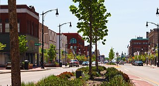
Superior is a city in, and the county seat of, Douglas County in the state of Wisconsin. The population was 27,244 at the 2010 census. Located at the junction of U.S. Highway 2 and U.S. Highway 53, it is immediately north of and adjacent to both the Village of Superior and the Town of Superior. Its neighborhoods include Billings Park, North End, South Superior, Central Park, East End, Allouez, and Itasca. Billings Park, South Superior, East End, and North End each have small business districts.

Upper Peninsula of Michigan Northern major peninsula of the U.S. state of Michigan

The Upper Peninsula (UP), also known as Upper Michigan, is the northern of the two major peninsulas that make up the U.S. state of Michigan. The peninsula is bounded on the north by Lake Superior, on the east by the St. Marys River, on the southeast by Lake Michigan and Lake Huron, and on the southwest by Wisconsin. Upper Peninsula counties also include nearby islands such as Grand, Drummond, Mackinac, and Bois Blanc, and more distant Isle Royale.

US Highway 2 (US 2), Wisconsin Highway 13, M-28, M-26, and US 41 are the main highways on or near this shoreline.

U.S. Route 2 highway in the United States

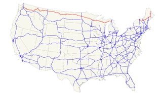
U.S. Route 2 or U.S. Highway 2 (US 2) is an east–west U.S. Highway spanning 2,571 miles (4,138 km) across the northern continental United States. US 2 consists of two segments connected by various roadways in southern Canada. Unlike some routes, which are disconnected into segments because of encroaching Interstate Highways, the two portions of US 2 were designed to be separate in the original 1926 highway plan.

State Trunk Highway 13 is a Wisconsin state highway running north–south across northwest and central Wisconsin. WIS 13 serves as a major north–south route connecting the communities of Wisconsin Dells, Wisconsin Rapids, Marshfield and Ashland. Highway 13 is part of the Lake Superior Circle Tour from its northern/western terminus to Ashland at is eastern junction with U.S. Highway 2. The road also provides access to the Apostle Islands National Lakeshore off the Lake Superior shoreline at Bayfield. The highway is two-lane surface road with the exception of various urban multilane road sections.

M-28 is an east–west state trunkline highway that traverses nearly all of the Upper Peninsula in the U.S. state of Michigan, from Wakefield to near Sault Ste. Marie in Bruce Township. Along with US Highway 2 (US 2), M-28 forms a pair of primary highways linking the Upper Peninsula from end to end, providing a major access route for traffic from Michigan and Canada along the southern shore of Lake Superior. M-28 is the longest state trunkline in Michigan numbered with the "M-" prefix at 290.373 miles (467.310 km). The entire highway is listed on the National Highway System, while three sections of M-28 are part of the Lake Superior Circle Tour. M-28 also carries two memorial highway designations along its route.

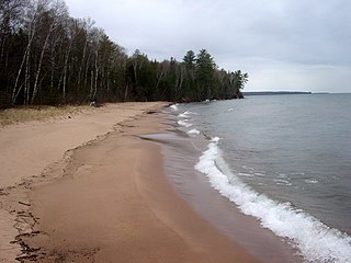
Scenic areas of Lake Superior's South Shore include:

Apostle Islands National Lakeshore protected area in Wisconsin

The Apostle Islands National Lakeshore is a U.S. national lakeshore consisting of 21 islands and shoreline encompassing 69,372 acres (28,074 ha) on the northern tip of Wisconsin on the shore of Lake Superior. It is known for its collection of historic lighthouses, sandstone sea caves, a few old-growth remnant forests, and natural animal habitats. It is featured on the America the Beautiful Quarters series.

Porcupine Mountains mountain in United States of America

The Porcupine Mountains, or Porkies, are a group of small mountains spanning the northwestern Upper Peninsula of Michigan in Ontonagon and Gogebic counties, near the shore of Lake Superior. The Porcupine Mountains were named by the native Ojibwa people, supposedly because their silhouette had the shape of a crouching porcupine. They are home to the most extensive stand of old growth northern hardwood forest in North America west of the Adirondack Mountains, spanning at least 31,000 acres (13,000 ha). In these virgin forests, sugar maple, American basswood, eastern hemlock, and yellow birch are the most abundant tree species. The area is part of the Porcupine Mountains Wilderness State Park.

Keweenaw Peninsula northernmost portion of Michigans Upper Peninsula

The Keweenaw Peninsula is the northernmost part of Michigan's Upper Peninsula. It projects into Lake Superior and was the site of the first copper boom in the United States. As of the 2000 census, its population was roughly 43,200. Its major industries are now logging and tourism, as well as jobs related to Michigan Technological University and Finlandia University.

See also

Related Research Articles

Lake Michigan one of the Great Lakes of North America

Lake Michigan is one of the five Great Lakes of North America and the only one located entirely within the United States. The other four Great Lakes are shared by the U.S. and Canada. It is the second-largest of the Great Lakes by volume and the third-largest by surface area, after Lake Superior and Lake Huron. To the east, its basin is conjoined with that of Lake Huron through the wide Straits of Mackinac, giving it the same surface elevation as its easterly counterpart; the two are technically a single lake.

Pictured Rocks National Lakeshore

Pictured Rocks National Lakeshore is a U.S. National Lakeshore on the shore of Lake Superior in the Upper Peninsula of Michigan, United States. It extends for 42 miles (67 km) along the shore and covers 73,236 acres. The park has extensive views of the hilly shoreline between Munising and Grand Marais in Alger County, Michigan, with picturesque rock formations, waterfalls, and sand dunes.

Lake Superior Lowland

In the U.S. state of Wisconsin, the Lake Superior Lowland, also known as the Superior Coastal Plain, is a geographical region located in the far northern part of the state bordering Lake Superior. It covers about 1,250 square miles (3,200 km2), and does not extend beyond 20 miles (32 km) from the Lake Superior shore.

M-209 was a state trunkline highway in the lower peninsula of the US state of Michigan. It was located in Leelanau County in the Sleeping Bear Dunes National Lakeshore. Until it was decommissioned, it was Michigan's shortest state highway. M-209 started at M-109 and went 0.543 miles (0.874 km) or just 956 yards (874 m) to Glen Haven. In 1996, M-209's designation was "abandoned", and the road was turned over to the jurisdiction of the Leelanau County Road Commission.

Michigan Island island in the United States of America

Michigan Island is one of the Apostle Islands located in western Lake Superior, off the Bayfield Peninsula, in northern Wisconsin. This island has no human inhabitants, and is managed by the National Park Service as part of the Apostle Islands National Lakeshore. It is centered at approximately 46.87° N 90.49° W and has a maximum elevation of 758' above sea level. Along its shores, it rises about 48 feet above Lake Superior's official elevation of 602'. The Michigan Island Light, which has two towers, is located on the island.

Ottawa National Forest national forest in Michigan, United States

The Ottawa National Forest is a national forest that covers 993,010 acres (401,860 ha) in the Upper Peninsula of the U.S. state of Michigan. It includes much of Gogebic and Ontonagon counties, as well as slices of Iron, Houghton, Baraga, and Marquette counties. The forest is under the jurisdiction of the U.S. Forest Service.

Red Cliff, Wisconsin Unincorporated community in Wisconsin, United States

Red Cliff, also known as Miskwaabikaang, is an unincorporated community in the town of Russell, Bayfield County, Wisconsin, United States. Red Cliff is the administrative center of the Red Cliff Band of Lake Superior Chippewa. The reservation population is 924, primarily Native American.

U.S. Route 12 (US 12) is a part of the United States Numbered Highway System that runs from Aberdeen, Washington, to Detroit, Michigan. In the U.S. state of Indiana, it is part of the state road system. US 12 enters the state concurrent with US 20 and US 41 in Whiting. The 45.16 miles (72.68 km) of US 12 that lie within Indiana serve as a major conduit. Some of the highway is listed on the National Highway System. Various sections are rural two-lane highway, urbanized four-lane undivided highway and one-way streets. The easternmost community along the highway is Michiana Shores at the Michigan state line.

M-64 (Michigan highway) highway in Michigan, United States

M-64 is a north–south state trunkline highway in the Upper Peninsula of the US state of Michigan. It runs for approximately 63 34 miles (102.6 km) through the western part of the state in land that is part of the Ottawa National Forest. The highway connects with County Trunk Highway B (CTH-B) at the state line near Presque Isle, Wisconsin. As it passes through dense forests, M-64 runs along lakes Gogebic and Superior. The northern end is at a junction with US Highway 45 (US 45) in Ontonagon.

<i>Escanaba in da Moonlight</i> 2001 film by Jeff Daniels

Escanaba in da Moonlight is a 2001 American comedy film written, directed, and starring Jeff Daniels. It is a comedy about hunting and hunting traditions and is set in the Escanaba, Michigan area. The film is known for its spectacular usage of upper peninsula language and slang. The movie is the film adaptation of the play of the same name, which premiered at Jeff Daniels' Purple Rose Theatre in Chelsea, Michigan.

Glen Haven, Michigan Unincorporated community in Michigan, United States

Glen Haven is a restored port village on the shore of Lake Michigan on the Leelanau Peninsula within the now Sleeping Bear Dunes National Lakeshore. Attractions include the Lake Michigan beach, a restored General Store and Blacksmith Shop. The unincorporated community is located in Glen Arbor Township.

Geography of Michigan

Michigan consists of two peninsulas that lie between east longitude, and are separated by the Straits of Mackinac, and some nearby islands. With the exception of two small areas that are drained by the Mississippi River by way of the Wisconsin River in the Upper Peninsula and by way of the Kankakee-Illinois River in the Lower Peninsula, Michigan is drained by the Great Lakes-St. Lawrence watershed and is the only state with the majority of its land thus drained.

The Great Lakes Circle Tour is a designated scenic road system connecting all of the Great Lakes and the St. Lawrence River. It consists of routes for circumnavigating the lakes, either individually or collectively.

Western Great Lakes forests Ecoregion (WWF)

The Western Great Lakes forests is a terrestrial ecoregion as defined by the World Wildlife Fund. It is within the Temperate Broadleaf and Mixed Forests ecozone of North America, in the United States' states of Michigan, Wisconsin and Minnesota, and the Canadian provinces of Ontario and Manitoba.

References