
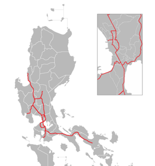
The South Luzon Expressway (SLEX), signed as E2 of the Philippine expressway network and R-3 of the Metro Manila arterial road network, is a limited-access toll expressway that connects Metro Manila to the provinces in the Calabarzon region on the island of Luzon in the Philippines. The expressway has a length of 46.9 km, traveling from its northern terminus at the Magallanes Interchange in Makati to its southern terminus at Santo Tomas, Batangas, connecting it to the Southern Tagalog Arterial Road. A portion of the expressway from the Magallanes Interchange to the Calamba Exit is part of Asian Highway 26 of the Asian highway network.
State Road 417 (SR 417), also known as the Central Florida GreeneWay, Seminole County Expressway, Eastern Beltway and Orlando East Bypass, is a tolled limited-access state highway forming the eastern beltway around the city of Orlando, Florida, United States. It is owned and maintained by the Central Florida Expressway Authority (CFX) and Florida's Turnpike Enterprise. The CFX section was posthumously named after former Orlando Orange County Expressway Authority chairman Jim Greene.

District of Columbia Route 295 (DC 295), also known as the Anacostia Freeway as well as the Kenilworth Avenue Freeway north of East Capitol Street, is a freeway in the District of Columbia, and currently the only signed numbered route in the District that is not an Interstate Highway or U.S. Highway. Also, DC 295 is one of the few city-level signed route numbers in the United States, along with Charlotte Route 4. The south end is at the junction of Interstate 295 (I-295), I-695, and the southern end of the 11th Street Bridges; its north end is at the border with Maryland where it continues as Maryland Route 201 (MD 201) and then the Baltimore–Washington Parkway.

Interstate 86 (I-86) is an Interstate Highway that extends for 223.39 miles (359.51 km) through northwestern Pennsylvania and the Southern Tier region of New York, in the United States. The highway has two segments: the longer of the two begins at an interchange with I-90 east of Erie, Pennsylvania, and ends just beyond the Chemung-Tioga county line at the Pennsylvania border, while the second extends from I-81 east of Binghamton to New York State Route 79 (NY 79) in Windsor. When projects to upgrade the existing NY 17 to Interstate Highway standards are completed, I-86 will extend from I-90 near Erie to the New York State Thruway (I-87) in Woodbury. The portion in Erie County, Pennsylvania, is known as the Hopkins-Bowser Highway and is signed as such at each end. In New York, the current and future alignment of I-86 is known as the Southern Tier Expressway west of I-81 in Binghamton and the Quickway east of I-81.

New York State Route 878 (NY 878) is a state highway on Long Island and in New York City. The route exists in two sections, which both form the Nassau Expressway. NY 878's western terminus is the Belt Parkway and Conduit Avenue (NY 27) in Ozone Park, within southern Queens. Its southern terminus is immediately before the Village of Atlantic Beach, at the Atlantic Beach Bridge in Lawrence, within southwestern Nassau County. NY 878 is discontinuous between Farmers Boulevard in Queens and the town of Inwood in Nassau County. The two sections are connected to each other by Rockaway Boulevard and Rockaway Turnpike.

Interstate 540 (I-540) and North Carolina Highway 540 (NC 540) are part of a partially completed beltway around the city of Raleigh in the US state of North Carolina, forming the Raleigh Outer Loop. When complete, the route will completely encircle the city, meeting its parent route of I-40 in two locations.

A controlled-access highway is a type of highway that has been designed for high-speed vehicular traffic, with all traffic flow—ingress and egress—regulated. Common English terms are freeway, motorway and expressway. Other similar terms include throughway and parkway. Some of these may be limited-access highways, although this term can also refer to a class of highways with somewhat less isolation from other traffic.
The Mon–Fayette Expressway is a partially-completed tolled freeway that is planned to eventually link Interstate 68 near Morgantown, West Virginia with Interstate 376 near Monroeville, Pennsylvania. The ultimate goal of the highway is to provide a high speed north–south connection between Morgantown and the eastern side of Pittsburgh while revitalizing economically distressed Monongahela River Valley towns in Fayette and Washington counties, serving as an alternative to Interstate 79 to the west, as well as relieving the PA 51 alignment from Pittsburgh to Uniontown.
An airport expressway is an expressway connecting to the airport as a road for vehicles going to the airport.
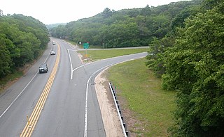
A two-lane expressway or two-lane freeway is an expressway or freeway with only one lane in each direction, and usually no median barrier. It may be built that way because of constraints, or may be intended for expansion once traffic volumes rise. The term super two is often used by roadgeeks for this type of road, but traffic engineers use that term for a high-quality surface road. Most of these roads are not tolled.

The Metro Manila Skyway, officially the Metro Manila Skyway System (MMSS) or simply the Skyway, is an elevated highway which is the main expressway in Metro Manila, Philippines. It connects the North and South Luzon Expressways with access to Ninoy Aquino International Airport via the NAIA Expressway (NAIAX). It is the first fully grade-separated highway in the Philippines and one of the longest elevated highways in the world, with a total length of approximately 39.2 kilometers (24.4 mi).

Interstate 94 (I-94) generally runs north–south through the northeastern portion of the US state of Illinois, in Lake and Cook counties. It is signed east–west in Illinois in accordance with its general alignment across the country, with west signage aligned with northbound travel and vice versa. I-94 in Illinois is 61.53 miles (99.02 km) long.

Circumferential Road 5 (C-5), informally known as the C-5 Road, is a network of roads and bridges that all together form the fifth beltway of Metro Manila in the Philippines. Spanning some 42.3 kilometers (26.3 mi), it connects the cities of Las Piñas, Makati, Parañaque, Pasay, Pasig, Quezon City, Taguig, and Valenzuela.

The Shanghai Ring Expressway (Chinese: 上海绕城高速公路; pinyin: Shànghǎi Ràochéng Gāosù Gōnglù), designated G1503, formerly designated as A30 and G1501, and also known as the Shanghai Suburb Ring Expressway (Chinese: 上海郊环高速公路; pinyin: Shànghǎi Jiāohuán Gāosù Gōnglù), is a 209.22-kilometre-long ring expressway (130.00 mi) that encircles Shanghai, a direct-controlled municipality in the People's Republic of China. It is entirely in Shanghai, except for a small section in the nearby province of Jiangsu at its northwest end.

Radial Road 3 (R-3), informally known as the R-3 Road, is a network of roads and bridges that all together form the third arterial road of Metro Manila in the Philippines. Spanning some 96 kilometers (60 mi), it connects the cities and municipalities of Batangas, Biñan, Cabuyao, Calamba, Ibaan, Lipa, Makati, Malvar, Muntinlupa, Parañaque, Pasay, San Jose, San Pedro, Santa Rosa, Santo Tomas, Taguig, and Tanauan in Batangas, Laguna, and Metro Manila.
There are 21 routes assigned to the "G" zone of the California Route Marker Program, which designates county routes in California. The "G" zone includes county highways in Monterey, San Benito, San Luis Obispo, Santa Clara, and Santa Cruz counties.
Northern Peripheral Road or NH 248-BB, commonly known as Dwarka Expressway is a 27.6 km (17.1 mi) long, under construction, 8-lane, elevated grade separated expressway connecting Dwarka in Delhi to Kherki Daula Toll Plaza, Gurgaon in Haryana. The expressway will take off from km 20 of NH 48 at Shiv Murti in Mahipalpur in Delhi and terminate at km 40 of NH 48 near Kherki Daula Toll Plaza in Gurgaon in Haryana. The NPR has been planned as an alternate road link between Delhi and Gurgaon, and is expected to ease the traffic situation on the Delhi-Gurgaon Expressway. The expressway was initially planned to be 18 km (11 mi) long and was expected to open by 2012 but land acquisition issues delayed the project.
The Philippine expressway network, also known as the High Standard Highway Network, is a controlled-access highway network managed by the Department of Public Works and Highways (DPWH) which consists of all expressways and regional high standard highways in the Philippines.

The Yokohama–Yokosuka Road is a toll road that links the city of Yokosuka, Kanagawa on the south end of the Miura Peninsula to Yokohama. It is numbered E16 under the "2016 Proposal for Realization of Expressway Numbering."