
Broadway is a road in the U.S. state of New York. Broadway runs from State Street at Bowling Green for 13 mi (21 km) through the borough of Manhattan and 2 mi (3.2 km) through the Bronx, exiting north from the city to run an additional 18 mi (29 km) through the municipalities of Yonkers, Hastings-On-Hudson, Dobbs Ferry, Irvington, and Tarrytown, and terminating north of Sleepy Hollow in Westchester County.

Interstate 35 (I-35) is a major Interstate Highway in the central United States. As with most interstates that end in a five, it is a major cross-country, north-south route stretching from Laredo, Texas, at the Mexican-American border to Duluth, Minnesota, at Minnesota Highway 61 and 26th Avenue East. The highway splits into Interstate 35E and Interstate 35W in two separate places, the Dallas–Fort Worth metroplex in Texas and at the Minnesota twin cities of Minneapolis–Saint Paul.

Traffic lights, also known as traffic signals, traffic lamps, traffic semaphore, signal lights, stop lights, robots, and traffic control signals, are signalling devices positioned at road intersections, pedestrian crossings, and other locations to control flows of traffic.

The Kansas City metropolitan area is a 14 county metropolitan area anchored by Kansas City, Missouri and straddling the border between the U.S. states of Missouri and Kansas. With a population of 2,104,509, it ranks as the second largest metropolitan area centered in Missouri. Alongside Kansas City, the area includes a number of other cities and suburbs, the largest being Overland Park, Kansas; Kansas City, Kansas; Olathe, Kansas; and Independence, Missouri; each over 100,000 in population. The Mid-America Regional Council (MARC) serves as the Council of Governments and the Metropolitan Planning Organization for the area.
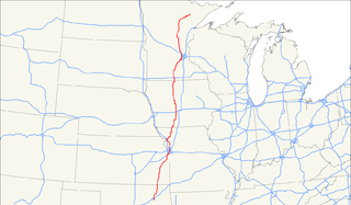
U.S. Route 169 currently runs for 966 miles (1,555 km) from the city of Virginia, Minnesota to Tulsa, Oklahoma at Memorial Drive.

A pedestrian scramble, also known as scramble intersection and scramble corner (Canada), 'X' Crossing (UK), diagonal crossing (US), exclusive pedestrian interval, or Barnes Dance, is a type of traffic signal movement that temporarily stops all vehicular traffic, thereby allowing pedestrians to cross an intersection in every direction, including diagonally, at the same time.

A jughandle is a type of ramp or slip road that changes the way traffic turns left at an at-grade intersection. Instead of a standard left turn being made from the left lane, left-turning traffic uses a ramp on the right side of the road. In a standard forward jughandle or near-side jughandle, the ramp leaves before the intersection, and left-turning traffic turns left off it rather than the through road. Right turns are also made using the jughandle.

Route 13 is a highway in Missouri which runs almost the entire north–south length of the state. Its northern terminus is at U.S. Route 69/136 in Bethany. Its southern terminus is at the Arkansas state line in downtown Blue Eye, Missouri–Arkansas where it continues as Highway 21. It is one of the original state highways of Missouri.
Route 210 is a highway in western Missouri with an eastern terminus at Route 10 southwest of Richmond and a western terminus just west of Interstate 35/U.S. Route 71, at the intersection of Ozark Street in North Kansas City. The roadway continues as Armour Road through downtown North Kansas City to intersect with Route 9. After I-35, 210 immediately intersects Missouri Route 1 and continues east. It intersects Walker Road in front of NKC Hospital and the Cerner world headquarters before an interchange with Chouteau Trafficway. It becomes a limited access freeway as it exits North Kansas City and into Kansas City proper. There are interchanges with North Brighton Avenue and Northeast Searcy Creek Parkway before it intersects I-435. Here, it reverts to a four-lane road with stoplights. It has intersections with the frontage road,Great Midwest Drive, and Eldon Road before becoming a two-lane road and going onto the river bottoms. It goes straight east, intersecting several roads, before curving northeast to intersect with Route 291.
Route 269 was a short highway in the Kansas City, Missouri area. Its total length was about two miles (3 km) and it is known as Chouteau Trafficway for its entire length. The northern terminus was at Interstate 35 in Kansas City; its southern terminus was at Front Street in Kansas City. The route had an interchange with Route 210 in North Kansas City. Chouteau Trafficway is a very narrow road for the amount of traffic it handles, so in the summer of 2011, all buildings located on Chouteau between NE Parvin Road and NE Winn Road were taken by eminent domain and razed in order to widen Route 269 into a four-lane boulevard. The route was relinquished to Kansas City in 2012 as part of the widening. However, the road is still signed.
Route 283 is a short highway in the Kansas City, Missouri regional area. Its northern terminus is at Interstate 29/U.S. Route 71 in Kansas City; its southern terminus is at Route 9 at the northern city limit of North Kansas City. It is known locally as North Oak Trafficway.
K-10 is a 38-mile (61 km) state highway in the U.S. state of Kansas. It was originally designated in 1929. It is mostly a controlled-access freeway, linking Lawrence to Lenexa. It provides an important toll-free alternate route to Interstate 70. Several scenes for the TV-movie The Day After were filmed on the highway at De Soto in 1982 portraying a mass exodus evacuating the Kansas City area on I-70.
U.S. Route 66, the historic east–west US highway between Chicago, Illinois and Santa Monica, California, passed through one brief segment in the southeastern corner of Kansas. It entered the state south of Baxter Springs and continued north until it crossed the Brush Creek, from where it turned east and left the state in Galena. After the decertification of the highway in 1985, this road segment was numbered as US-69 (alternate) from Quapaw, Oklahoma north to Riverton, Kansas and as K-66 from Riverton east to Route 66 in Missouri.

The Metro Area Express (MAX) is express bus service with bus rapid transit characteristics run by the Kansas City Area Transportation Authority in Kansas City, Missouri, United States. The first service opened on Main Street on July 2005. The second service on Troost Avenue opened on January 1, 2011. MAX was an instant success, with ridership on the first MAX line increasing more than 50%. The Federal Transit Administration holds it up as a model BRT line. MAX has little mileage of dedicated lanes, and lacks off-board fare collection and platform boarding.

Kansas City Public Schools or KCPS is a provisionally accredited school district headquartered at 2901 Troost Avenue in Kansas City, Missouri, USA. The district, which lost accreditation in 2011, regained provisional accreditation from the state in 2014. In November 2016, the district announced it had gotten a high enough score on state accountability measures for the State Board of Education to consider full accreditation. However, the state's education commissioner told KCPS she wanted to see sustained progress. The earliest the district is likely to regain full accreditation is 2018.
A total of fourteen special routes of U.S. Route 71 exist.
Volker is a historic neighborhood in Kansas City, MO that lies just northwest of the Westport historic and entertainment district. The 39th Street West District and the Old Westport Shopping Center lie within the Volker neighborhood. The boundaries of the Volker Neighborhood are 31st Street on the north and Westport Road/43rd Street on the south. The western boundary is State Line Road. On the east, the boundaries are Roanoke Road on the north side of 39th and Southwest Trafficway south of 39th.
39th Street is a major west/east main street that runs in Kansas City, Missouri from State Line Road to Topping Avenue. It was originally named Rosedale Avenue as it led to the town of Rosedale. It connects Westport and Kansas City, Kansas. The University of Kansas Hospital is at the starting point and the ending point is in the Leeds Industrial District.
Valentine is a historic neighborhood in Kansas City, Missouri. It is just north of the Westport entertainment district, bounded by Broadway on the east, Southwest Trafficway on the west, 31st Street on the north, and 40th Street on the south.
The US 69 Missouri River Bridge is a girder bridge carrying U.S. Route 69 (US 69) over the Missouri River. It connects Interstate 635 (I-635) in Riverside, Missouri with the 7th Street Trafficway and Fairfax District in Kansas City, Kansas. Construction began in the fall of 2014. The bridge opened to automobile traffic in October 2016 and was formally opened to all traffic on March 16, 2017. In addition to automobiles, the bridge also carries bicycle and pedestrian traffic. It replaced the now-demolished Fairfax and Platte Purchase bridges. The bridge was constructed by the Missouri Department of Transportation at cost of $79 million. Construction costs were split with the Kansas Department of Transportation.


