Ifni was a Spanish province on the Atlantic coast of Morocco, south of Agadir and across from the Canary Islands. It had a total area of 1,502 km2 (580 sq mi), and a population of 51,517 in 1964. The main industry was fishing. The present-day Moroccan province in the same area is called Sidi Ifni, with its capital in the city of the same name, but encompassing a much larger territory.

Cape Juby is a cape on the coast of southern Morocco, near the border with Western Sahara, directly east of the Canary Islands.

The plazas de soberanía are a series of Spanish overseas minor territories scattered along the Mediterranean coast bordering Morocco in Africa, or that are closer to Africa than Europe. This term is used for those territories that have been a part of Spain since the formation of the modern country (1492–1556), as opposed to African territories acquired by Spain during the 19th and early 20th centuries in the Scramble for Africa.
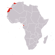
Spanish Sahara, officially the Spanish Possessions in the Sahara from 1884 to 1958, then Province of the Sahara between 1958 and 1976, was the name used for the modern territory of Western Sahara when it was occupied and ruled by Spain between 1884 and 1976. It had been one of the most recent acquisitions, as well as one of the last remaining holdings, of the Spanish Empire, which had once extended from the Americas to the Spanish East Indies.

Cape Juby is the name of the former southern part of the spanish protectorate of Morocco (1912–1956). Its on the coast of southern Morocco, near its border with Western Sahara, directly east of the Canary Islands.

The Spanish protectorate in Morocco was established on 27 November 1912 by a treaty between France and Spain that converted the Spanish sphere of influence in Morocco into a formal protectorate.

Sidi Ifni is a city located on the west coast of Morocco, on the shores of the Atlantic Ocean, with a population of 20,051 people. The economic base of the city is fishing. It is located in Guelmim-Oued Noun region and Sidi Ifni Province. Its inhabitants are the Shilha from the Ait Baamrane ethnic group. In 2000, an important fishing port was completed, which serves as a base for fish exports.
Spanish West Africa was a grouping of Spanish colonies along the Atlantic coast of northwest Africa. It was formed in 1946 by joining the southern zone of the Spanish protectorate in Morocco with the colonies of Ifni, Saguia el-Hamra and Río de Oro into a single administrative unit. Following the Ifni War (1957–58), Spain ceded the Cape Juby Strip to Morocco by the Treaty of Angra de Cintra, and created separate provinces for Ifni and the Sahara in 1958.
Greater Morocco is a label historically used by some Moroccan nationalist political leaders protesting against Spanish, Portuguese, Algerian and French rule, to refer to wider territories historically associated with the Moroccan sultan. Current usage most frequently occurs in a critical context, accusing Morocco, largely in discussing the disputed Western Sahara, of irredentist claims on neighboring territories.
The Army of Africa, also known as the Moroccan Army Corps, was a field army of the Spanish Army that garrisoned the Spanish protectorate in Morocco from 1912 until Morocco's independence in 1956.
Spanish North Africa may refer to:
Ceuta and Melilla may refer to:

The African Union covers almost the entirety of continental Africa and several off-shore islands. Consequently, it is wildly diverse, including the world's largest hot desert, huge jungles and savannas, and the world's longest river.

MoroccoandSpain maintain extensive diplomatic, commercial, and military ties. The Morocco–Spain border separates the plazas de soberanía on the Mediterranean coast from the Moroccan mainland. Morocco's foreign policy has focused on Western partners, including neighboring Spain. Relations have, however, been historically tense and conflictive.
The Morocco–Spain land border consists of three non-contiguous lines totalling 18.5 km around the Spanish territories of Ceuta, Peñón de Vélez de la Gomera and Melilla. Spanish islets such as the Chafarinas or the Alhucemas are located off the Moroccan coast.
The European enclaves in North Africa were towns, fortifications and trading posts on the Mediterranean and Atlantic coasts of western North Africa, obtained by various European powers in the period before they had the military capacity to occupy the interior. The earliest of these were established in the 11th century CE by the Italian Kingdom of Sicily and Maritime republics; Spain and Portugal were the main European powers involved; both France and, briefly, England also had a presence. Most of these enclaves had been evacuated by the late 18th century, and today only the Spanish possessions of Ceuta, Melilla, and the Plazas de soberanía remain.

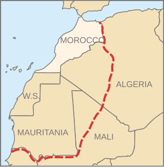
The Morocco–Western Sahara border is 444 kilometres (276 mi) in length and runs from Atlantic Ocean in the west, to the tripoint with Algeria in the east. The border has existed purely in a de jure sense since Morocco's annexation of Western Sahara in 1976–1979.

The Mauritania–Western Sahara border is 1,564 kilometres (972 mi) in length and runs from the tripoint with Algeria in the north-east to the Atlantic Ocean in the south-west.