
Vilas County is a county in the state of Wisconsin, United States. As of the 2020 census, the population was 23,047. Its county seat is Eagle River. The county partly overlaps the reservation of the Lac du Flambeau Band of Lake Superior Chippewa.

Eagle River is a city in Vilas County, Wisconsin, United States. The population was 1,628 at the 2020 census. It is the county seat of Vilas County. Because of the many lakes in the area, the city is a popular vacation and retirement destination. The area contains many condominiums, seasonal vacation homes, and hunting cabins.
Kettle Moraine is a large moraine in the state of Wisconsin, United States. It stretches from Walworth County in the south to Kewaunee County in the north. It has also been referred to as the Kettle Range and, in geological texts, as the Kettle Interlobate Moraine.
There are 116 lakes named Mud Lake in the U.S. state of Wisconsin. Mud Lake is the most common lake name in the state. Because of the way GNIS is organized some of the names listed below may be for the same lake.

Lake Minocqua is a freshwater natural drainage lake in northern Oneida County, Wisconsin. It is 1360 acres (5.5 km²) in area, with an average depth of 23 feet (7 m) and a maximum depth of 60 feet (18.3 m).

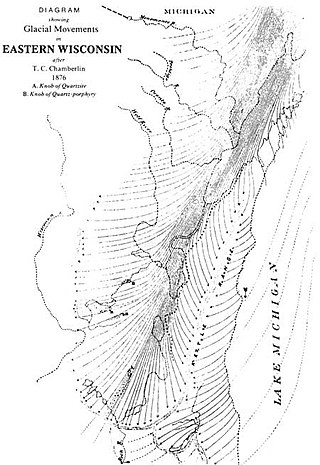
Wisconsin, a state in the Midwestern United States, has a vast and diverse geography famous for its landforms created by glaciers during the Wisconsin glaciation 17,000 years ago. The state can be generally divided into five geographic regions—Lake Superior Lowland, Northern Highland, Central Plain, Eastern Ridges & Lowlands, and Western Upland. The southwestern part of the state, which was not covered by glaciers during the most recent ice age, is known as the Driftless Area. The Wisconsin glaciation formed the Wisconsin Dells, Devil's Lake, and the Baraboo Range. A number of areas are protected in the state, including Devil's Lake State Park, the Apostle Islands National Lakeshore, and the Chequamegon–Nicolet National Forest.
Dell Creek is a warm freshwater stream that lies in northeastern Sauk County and southern Juneau County in central Wisconsin. Dell Creek was named from the dells which occur along its course. Dell Creek is a warm water sport fishery for the lower 1.5 miles and a Class II trout stream for the upper 10.5 miles of its length. The creek is classified as an exceptional resource water. Much of Dell Creek's length in Sauk County is publicly owned.
Lost Lake is located in the town of St. Germain, in Vilas County, Wisconsin, United States. It is 544 acres (2.20 km2) in size and has a maximum depth of 22 feet (6.7 m). Visitors have access to the lake from a public boat landing. Fish include Musky, Panfish, Largemouth Bass, Northern Pike and Walleye.

The Tomahawk River is a river in the U.S. state of Wisconsin.

Trout Lake is in Vilas County, Wisconsin, near the towns of Boulder Junction and Arbor Vitae, Wisconsin. With a surface area of 6.208 sq mi (16.079 km2) and a volume of 0.058 cu mi (0.240 km3), Trout Lake is one of the largest lakes in Vilas County. It has 16.1 mi (25.9 km) of shoreline, a large portion of which is undeveloped. There are also seven islands within the lake: Miller Island, Zimmerman Island, Haunted Island, Easter Island, Fisk Island, Chocolate Drop Island, and an unnamed island. It is a dimictic oligotrophic lake that supports a large number of sport fish, which has made it a popular angling destination.
White Birch Village is a vacation resort located in Boulder Junction, Wisconsin.

The Turtle-Flambeau Flowage is a 12,942 acres (52.37 km2) lake in Iron County, Wisconsin. It has a maximum depth of 15 meters and is the seventh largest lake in the state of Wisconsin by surface area. The flowage is home to unique wetland patterns and plant species as well as several species of sport and game fish, including Musky, Panfish, Largemouth Bass, Smallmouth Bass, Northern Pike, Walleye and Sturgeon. The lake's water clarity is low, but can vary in different locations in the lake. Fishing, camping, boating, and hunting are popular activities on the flowage, and Ojibwe people traditionally harvest fish and game on the lake. Environmental concerns on the flowage include mercury contamination, algal blooms, and several types of invasive species.

There are a variety of schema for dividing Wisconsin into regions.
Crystal Lake is one of at least 22 lakes of that name in the state of Wisconsin. It has a surface area of about 93 acres, and is located just south of Big Muskellunge Lake, in Vilas County in the Northern Highland region of Wisconsin. The nearest community is Sayner, about 5 miles to the east. Visitors have access to the lake from a public boat landing, public beaches and the Northern Highland-American Legion State Forest. Fish include panfish, largemouth bass, and trout.

The Jersey City Flowage is an artificial lake on the Tomahawk River, located about one mile above the confluence with the Wisconsin River in Tomahawk, Wisconsin. The dam and the flow are controlled by the Wisconsin Valley Improvement Company. The dam was originally built in 1910 to provide power for a tannery.Jersey City Flowage is a 423 acre lake located in Lincoln County. It has a maximum depth of 20 feet.

The Turtle River is a river in Vilas County and Iron County in the state of Wisconsin in the United States. Its source is South Turtle Lake near Winchester. It flows into the Turtle-Flambeau Flowage.Little Turtle River Flowage is a 30 acre lake located in Iron County. It has a maximum depth of 4 feet.

The Southern Unit of the Kettle Moraine State Forest includes more than 22,000 acres of land throughout southern Wisconsin and spans several state parks and natural areas. The area also features varied environments from restored prairie, forests, and lakes, along with providing a multitude of recreational opportunities such as hiking, birdwatching, fishing, camping, and hunting. The Kettle Moraine Scenic Drive also extends within this region as well as through a larger portion of the state.
Fence Lake is a 3,483 acre lake in Vilas County, Wisconsin. The communities of Marlands and Lac du Flambeau border the lake. The fish present in the lake are Muskellunge, Panfish, Largemouth Bass, Smallmouth Bass, Northern Pike, Trout and Walleye.

Flambeau Lake is a 1,166 acre lake in Vilas County, Wisconsin, USA. The community of Lac du Flambeau completely surrounds the lake. Fish present in the lake are muskellunge, largemouth bass, smallmouth bass, northern pike and walleye. There is one boat ramp on the northeast shore, accessible from Highway 47. It has a maximum depth of 78 feet. Visitors have access to the lake from a public boat landing. Fish include Musky, Panfish, Largemouth Bass, Smallmouth Bass, Northern Pike and Walleye.
Squirrel Lake is a 1,309 acres (530 ha) lake in Vilas County and Oneida County, Wisconsin. It has a maximum depth of 46 feet. Several species of fish inhabit the lake and fishing is accessible via a public boat launch. Writer Winifred Dunn spent time during her youth on an island at Squirrel Lake. Minocqua, Wisconsin and the community of Bo-Di-Lac border the lake. The max depth is 46 feet (14 m).
