
Systems engineering is an interdisciplinary field of engineering and engineering management that focuses on how to design and manage complex systems over their Life cycles. At its core, systems engineering utilizes systems thinking principles to organize this body of knowledge. The individual outcome of such efforts, an engineered system, can be defined as a combination of components that work in synergy to collectively perform a useful function.
A simulation is an approximate imitation of the operation of a process or system; the act of simulating first requires a model is developed. This model is a well-defined description of the simulated subject, and represents its key characteristics, such as its behaviour, functions and abstract or physical properties. The model represents the system itself, whereas the simulation represents its operation over time.

Transportation planning is the process of defining future policies, goals, investments, and designs to prepare for future needs to move people and goods to destinations. As practiced today, it is a collaborative process that incorporates the input of many stakeholders including various government agencies, the public and private businesses. Transportation planners apply a multi-modal and/or comprehensive approach to analyzing the wide range of alternatives and impacts on the transportation system to influence beneficial outcomes.
Software development is the process of conceiving, specifying, designing, programming, documenting, testing, and bug fixing involved in creating and maintaining applications, frameworks, or other software components. Software development is a process of writing and maintaining the source code, but in a broader sense, it includes all that is involved between the conception of the desired software through to the final manifestation of the software, sometimes in a planned and structured process. Therefore, software development may include research, new development, prototyping, modification, reuse, re-engineering, maintenance, or any other activities that result in software products.

IDEF, initially abbreviation of ICAM Definition, renamed in 1999 as Integration DEFinition, refers to a family of modeling languages in the field of systems and software engineering. They cover a wide range of uses, from functional modeling to data, simulation, object-oriented analysis/design and knowledge acquisition. These "definition languages" were developed under funding from U.S. Air Force and although still most commonly used by them, as well as other military and United States Department of Defense (DoD) agencies, are in the public domain.
Software prototyping is the activity of creating prototypes of software applications, i.e., incomplete versions of the software program being developed. It is an activity that can occur in software development and is comparable to prototyping as known from other fields, such as mechanical engineering or manufacturing.
Demand management is a planning methodology used to forecast, plan for and manage the demand for products and services. This can be at macro-levels as in economics and at micro-levels within individual organizations. For example, at macro-levels, a government may influence interest rates in order to regulate financial demand. At the micro-level, a cellular service provider may provide free night and weekend use in order to reduce demand during peak hours.
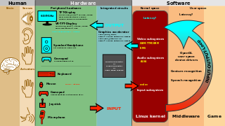
User interface design (UI) or user interface engineering is the design of user interfaces for machines and software, such as computers, home appliances, mobile devices, and other electronic devices, with the focus on maximizing usability and the user experience. The goal of user interface design is to make the user's interaction as simple and efficient as possible, in terms of accomplishing user goals.
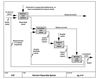
IDEF0, a compound acronym, is a function modeling methodology for describing manufacturing functions, which offers a functional modeling language for the analysis, development, reengineering, and integration of information systems; business processes; or software engineering analysis.
Geovisualization or geovisualisation, refers to a set of tools and techniques supporting the analysis of geospatial data through the use of interactive visualization.

Spatial analysis or spatial statistics includes any of the formal techniques which study entities using their topological, geometric, or geographic properties. Spatial analysis includes a variety of techniques, many still in their early development, using different analytic approaches and applied in fields as diverse as astronomy, with its studies of the placement of galaxies in the cosmos, to chip fabrication engineering, with its use of "place and route" algorithms to build complex wiring structures. In a more restricted sense, spatial analysis is the technique applied to structures at the human scale, most notably in the analysis of geographic data.
Participatory planning is an urban planning paradigm that emphasizes involving the entire community in the strategic and management processes of urban planning; or, community-level planning processes, urban or rural. It is often considered as part of community development. Participatory planning aims to harmonize views among all of its participants as well as prevent conflict between opposing parties. In addition, marginalized groups have an opportunity to participate in the planning process.
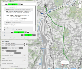
A journey planner, trip planner, or route planner is a specialised search engine used to find an optimal means of travelling between two or more given locations, sometimes using more than one transport mode. Searches may be optimised on different criteria, for example fastest, shortest, fewest changes, cheapest. They may be constrained for example to leave or arrive at a certain time, to avoid certain waypoints, etc. A single journey may use a sequence of several modes of transport, meaning that the system may know about public transport services as well as transport networks for private transportation. Trip planning or Journey planning is sometimes distinguished from route planning, where route planning is typically thought of as using private modes of transportation such as driving, walking, or cycling, normally using a single mode at a time. Trip or Journey planning by contrast would make use of at least one public transport mode which operates according to published schedules; given that public transport services only depart at specific times, an algorithm must therefore not only find a path to a destination, but seek to optimise it so as to minimise the waiting time incurred for each leg.
A public participation geographic information system (PPGIS) is meant to bring the academic practices of GIS and mapping to the local level in order to promote knowledge production by local and non-governmental groups. The idea behind PPGIS is empowerment and inclusion of marginalized populations, who have little voice in the public arena, through geographic technology education and participation. PPGIS uses and produces digital maps, satellite imagery, sketch maps, and many other spatial and visual tools, to change geographic involvement and awareness on a local level. The term was coined in 1996 at the meetings of the National Center for Geographic Information and Analysis (NCGIA).

AnyLogic is a multimethod simulation modeling tool developed by The AnyLogic Company. It supports agent-based, discrete event, and system dynamics simulation methodologies. AnyLogic is a cross-platform simulation software as far as it works on Windows, macOS and Linux.
UrbanSim is an open source urban simulation system designed by Paul Waddell of the University of California, Berkeley and developed with numerous collaborators to support metropolitan land use, transportation, and environmental planning. It has been distributed on the web since 1998, with regular revisions and updates, from www.urbansim.org. Synthicity Inc coordinates the development of UrbanSim and provides professional services to support its application. The development of UrbanSim has been funded by several grants from the National Science Foundation, the U.S. Environmental Protection Agency, the Federal Highway Administration, as well as support from states, metropolitan planning agencies and research councils in Europe and South Africa. Reviews of UrbanSim and comparison to other urban modeling platforms may be found in references.
VGE is related to such technologies as GIS( 3-D GIS ), RS, geovisualization, GeoComputation, virtual reality, network and communication, agents, geo-cognition and so on.
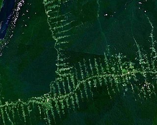
Land change models (LCMs) describe, project, and explain changes in and the dynamics of land use and land-cover. LCMs are a means of understanding ways that humans are changing the Earth's surface in the past, present, in forecasting land change into the future.
