Look up spearhead in Wiktionary, the free dictionary.
A spearhead is the sharpened point (head) of a spear, similar to an arrowhead. It is often a separate piece called a projectile point.
Contents
Spearhead may also refer to:
A spearhead is the sharpened point (head) of a spear, similar to an arrowhead. It is often a separate piece called a projectile point.
Spearhead may also refer to:
Whistler may refer to:
Whistler is a resort municipality in the southern Pacific Ranges of the Coast Mountains in the unceded territories of Squamish, British Columbia. Approximately 125 km (78 mi) north of Vancouver and 36 km (22 mi) south of Pemberton, it is incorporated as the Resort Municipality of Whistler (RMOW). It has a permanent population of approximately 13,982 (2021), as well as a larger but rotating population of seasonal workers.
Sentinel may refer to:
A hunter is a person who hunts.
Black is a color corresponding to the absence of light.
A monarch is a ruler in a system (monarchy) where succession is hereditary.
Liberator or The Liberators or variation, may refer to:
Blood is a biological fluid found in animals.
Sunrise is the instant at which the upper edge of the Sun appears above the horizon in the east.
A snake is an elongated, legless, predatory reptile.
The Castle may refer to:

Blackcomb Peak is a mountain located east of Whistler, British Columbia that forms the boundary between the Whistler Blackcomb ski resort and Garibaldi Provincial Park. Like Whistler Mountain, it is located on the edge of Garibaldi Provincial Park and the ski lifts are often used to access the park, particularly for the Spearhead Traverse.
Beast most often refers to:

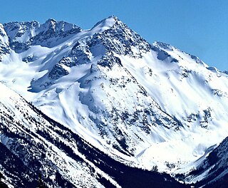
The Spearhead is a 2,457 m (8,061 ft) peak in the Garibaldi Ranges of British Columbia, Canada, and is one of the main summits of the Blackcomb Mountain portion of the Whistler Blackcomb ski resort, located at the apex of the Blackcomb and Spearhead Glaciers, which is named for it. It also is the namesake of the Spearhead Range, which is the short range flanking the north side of Fitzsimmons Creek and ending on its northwest end at Blackcomb Mountain. The mountain's name was officially adopted on August 27, 1965, by the Geographical Names Board of Canada.
The Spearhead Range is a short subrange of the Garibaldi Ranges of southwestern British Columbia, Canada, adjacent to the resort town of Whistler, British Columbia and ending at its northwestern apex in Blackcomb Mountain, one of two mountains forming the Whistler Blackcomb ski resort. Other notable summits are Tremor Mountain, The Spearhead, Mount Macbeth, Decker Mountain, Mount Trorey, and Shatter, Shudder, Quiver and other similarly named peaks and glaciers. The range was named by Don and Phyllis Munday as the range's peaks resembled spearheads rising from the alpine fog. To the north of the range is Lone Goat Pass, formed by Wedge Creek and Lone Goat Creek, which is fed by the Spearhead Glacier, the largest glacier in the range. The valley of Fitzsimmons Creek is on the range's south side, and is the location of the Whistler Sliding Centre, which was built for the 2010 Winter Olympics.
The Spearhead Glacier is the largest glacier on the Spearhead Range, located on the opposite, northeast side of that range from the resort town of Whistler, British Columbia, Canada, and is serviced in part by the lift system of the Whistler Blackcomb ski resort. The glacier's apex is at the peak known as The Spearhead, which also lies at the head of the Blackcomb Glacier.
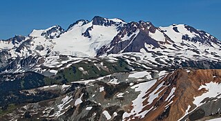
Overlord Mountain is a 2,625-metre (8,612-foot) glacier-clad peak located in the Garibaldi Ranges of the Coast Mountains, in Garibaldi Provincial Park of southwestern British Columbia, Canada. It is the highest point of the Fitzsimmons Range, which is a subset of the Garibaldi Ranges, and can be readily seen from the Whistler Blackcomb ski area. It is situated 15 km (9 mi) southeast of Whistler, and its nearest higher peak is Mount Macbeth, 3 km (2 mi) to the north-northeast. The Benvolio Glacier rests below the south aspect of the summit, the Fitzsimmons Glacier on the east aspect, and the expansive Overlord Glacier spans the northern and western aspects of the mountain. Precipitation runoff from the peak and meltwater from its glaciers drains into tributaries of the Cheakamus River. The first ascent of the mountain was made in 1923 by Phyllis Munday and Don Munday via the Benvolio Glacier. The mountain's descriptive name was recommended by the Garibaldi Park Board and officially adopted on September 2, 1930, by the Geographical Names Board of Canada.
Mount Macbeth is a 2,639-metre (8,658-foot) glacier-clad peak located in the Garibaldi Ranges of the Coast Mountains, in Garibaldi Provincial Park of southwestern British Columbia, Canada. It is part of the Spearhead Range, which is a subset of the Garibaldi Ranges. It is situated 14 km (9 mi) southeast of Whistler, and 2 km (1 mi) south of Tremor Mountain, which is the highest point in the Spearhead Range. The Naden Glacier spreads out below the eastern aspect of the summit, the Macbeth Glacier lies below the south aspect, and the Curtain Glacier descends the northern slope. Precipitation runoff from the peak and meltwater from its glaciers drains into Fitzsimmons Creek which is a tributary of the Cheakamus River. Macbeth is most often climbed as part of the Spearhead Traverse. The first ascent of the mountain was made in 1969 by P. Starr, E. Bass, B. Ellis, and P. Macec via the northeast ridge. The peak was named in 1964 by an Alpine Club of Canada climbing party, to commemorate the 400th anniversary of William Shakespeare's birth. The mountain's name was officially adopted on August 27, 1965, by the Geographical Names Board of Canada.

Decker Mountain is a 2,421-metre (7,943-foot) flat-topped peak located in the Garibaldi Ranges of the Coast Mountains, in Garibaldi Provincial Park of southwestern British Columbia, Canada. It is part of the Spearhead Range, which is a subset of the Garibaldi Ranges. It is situated 9 km (6 mi) southeast of Whistler, and 3.9 km (2 mi) west-northwest of Tremor Mountain, which is the highest point in the Spearhead Range. Precipitation runoff from the south side of the peak drains into Fitzsimmons Creek which is a tributary of the Cheakamus River, and meltwater from the Decker Glacier on the northeastern slope drains to Wedge Creek.

Tremor Mountain is a prominent 2,691-metre (8,829-foot) summit located in the Garibaldi Ranges of the Coast Mountains, in Garibaldi Provincial Park of southwestern British Columbia, Canada. It is the highest point of the Spearhead Range, which is a subset of the Garibaldi Ranges. It is situated 13 km (8 mi) southeast of Whistler, and 8.7 km (5 mi) south of Wedge Mountain, its nearest higher peak. Precipitation runoff from the south side of the peak as well as meltwater from the Platform Glacier drains into Fitzsimmons Creek which is a tributary of the Cheakamus River. Meltwater from the Tremor Glacier on the northwestern slope drains to Wedge Creek, and meltwater from the Shudder Glacier on the northeast slope drains into Billygoat Creek, a tributary of the Lillooet River. Tremor Mountain is often climbed as part of the Spearhead Traverse. The first ascent of the mountain was made in 1928 by A.J. Campbell Garibaldi survey party. The mountain's name origin refers to unexplained earth tremors when the first ascent party was on the summit. The mountain's name was officially adopted on September 6, 1951, by the Geographical Names Board of Canada.