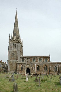
Chesterfield is a large market town and borough in Derbyshire, England. It lies 24 miles (39 km) north of Derby and 11 miles (18 km) south of Sheffield at the confluence of the rivers Rother and Hipper. Including Whittington, Brimington and Staveley it had a population of about 103,800 in 2011, making it the second largest town in the ceremonial county after Derby. Archaeologists trace it back to a Roman fort built in the 1st century AD, but soon abandoned. Later an Anglo-Saxon village developed. The name derives from the Old English ceaster and feld. It has a street market of some 250 stalls three days a week. The town sits on a coalfield, which was economically important until the 1980s. Little visual evidence of mining remains. The best-known landmark is the Church of St Mary and All Saints with its crooked spire, originally built in the 14th century.

Evesham is a market town and parish in the Wychavon district of Worcestershire, southern England with a population of 23,576, according to the 2011 census. It is located roughly equidistant between Worcester, Cheltenham and Stratford-upon-Avon. It lies within the Vale of Evesham, an area comprising the flood plain of the River Avon, which has been renowned for market gardening. The town centre, situated within a meander of the river, is regularly subject to flooding. The 2007 floods were the most severe in recorded history.

Nuneaton is a town in northern Warwickshire, England. The population in 2011 was 86,552, making it the largest town in Warwickshire.

Wantage is a historic market town and civil parish in the ceremonial county of Oxfordshire, England. Historically part of Berkshire, it has been administered as part of the Vale of White Horse district of Oxfordshire since 1974. The town is on Letcombe Brook, about 8 miles (13 km) south-west of Abingdon, 24 miles (39 km) north-west of Reading, 15 miles (24 km) south-west of Oxford and 14 miles (23 km) north north-west of Newbury.

Chippenham is a large historic market town in northwest Wiltshire, England. It lies 20 miles (32 km) east of Bristol, 86 miles (138 km) west of London and 4 miles (6 km) west of The Cotswolds AONB. The town was established on a crossing of the River Avon and some form of settlement is believed to have existed there since before Roman times. It was a royal vill, and probably a royal hunting lodge, under Alfred the Great. The town continued to grow when the Great Western Railway arrived in 1841; it is now a major commuter town.

Louth is a market town and civil parish in the East Lindsey district of Lincolnshire, England. Louth is the principal town and centre for a large rural area of eastern Lincolnshire. Visitor attractions include St. James' Church, Hubbard's Hills, the market, many independent retailers and Lincolnshire's last remaining cattle market.

Almondsbury is a large village near junction 16 of the M5 motorway, in South Gloucestershire, England, and a civil parish which also includes the villages of Hortham, Gaunt's Earthcott, Over, Easter Compton, Compton Greenfield, and Hallen.
Sutton-in-Ashfield is a market town in the Ashfield district of Nottinghamshire, England, with a population of around 45,804. It is situated four miles west of Mansfield, two miles from the Derbyshire border and twelve miles north of Nottingham.
Saint Mary's College, is the name of several colleges and schools:

Stradbroke is a village in the English county of Suffolk. It is in the Mid Suffolk district and part of the East of England region of England. The Census of 2011 gave Stradbroke a population of 1,408, following an estimate of 1,330 in 2005.

Sir Leonard George Holden Huxley was an Australian physicist.

Donington is a large village and civil parish in the South Holland district of Lincolnshire, England. It is situated 8 miles (13 km) north from the market town of Spalding on the A152, and is bypassed by the A52. Donington also conveniently sits between the A16 and A17. The parish includes the hamlet of Northorpe, and
falls within the drainage area of the Black Sluice Internal Drainage Board. Donington is the birthplace of the explorer Matthew Flinders.

Bitterne is an eastern suburb and ward of Southampton, England.

Berinsfield is a village and civil parish in South Oxfordshire, about 7 miles (11 km) southeast of Oxford.

Summertown in North Oxford is a suburb of Oxford, England.
Middleton Cheney is a village and civil parish in South Northamptonshire, England. The village is about 3 miles (5 km) east of Banbury in Oxfordshire and about 6 miles (10 km) west-northwest of Brackley. The A422 road between Banbury and Brackley used to pass through Middleton Cheney, but now bypasses it to the south.

Goldington is an electoral ward within the town of Bedford, Bedfordshire, England. It encompasses much of the historic village and parish of Goldington that was merged with Bedford in 1934, although some parts of the old village are within the neighbouring Newnham ward. It also includes two modern estates that are part of Renhold Parish.
William Gordon Wheeler was an English prelate and the Bishop Emeritus of the Roman Catholic Diocese of Leeds, England. Wheeler had served as the seventh Roman Catholic Bishop of Leeds, being succeeded by David Konstant. Before that, Wheeler served as Coadjutor Bishop of the Diocese of Middlesbrough and as Titular Bishop of Theudalis.