
A tumulus is a mound of earth and stones raised over a grave or graves. Tumuli are also known as barrows, burial mounds or kurgans, and may be found throughout much of the world. A cairn, which is a mound of stones built for various purposes, may also originally have been a tumulus.
A feature in archaeology and especially excavation is a collection of one or more contexts representing some human non-portable activity that generally has a vertical characteristic to it in relation to site stratigraphy. Examples of features are pits, walls, and ditches. General horizontal elements in the stratigraphic sequence, such as layers, dumps, or surfaces are not referred to as features. Examples of surfaces include yards, roads, and floors. Features are distinguished from artifacts in that they cannot be separated from their location without changing their form.

In archaeology a section is a view in part of the archaeological sequence showing it in the vertical plane, as a cross section, and thereby illustrating its profile and stratigraphy. This may make it easier to view and interpret as it developed over time.
Urban archaeology is a sub discipline of archaeology specialising in the material past of towns and cities where long-term human habitation has often left a rich record of the past.

The Chestnuts Long Barrow, also known as Stony or Long Warren, is a chambered long barrow located near to the village of Addington in the southeastern English county of Kent. Constructed circa 4000 BCE, during the Early Neolithic period of British prehistory, today it survives only in a ruined state.

The Harris matrix is a tool used to depict the temporal succession of archaeological contexts and thus the sequence of depositions and surfaces on a 'dry land' archaeological site, otherwise called a 'stratigraphic sequence'. The matrix reflects the relative position and stratigraphic contacts of observable stratigraphic units, or contexts. The Matrix was developed in 1973 in Winchester, England, by Dr. Edward C. Harris.

Ringinglow is a village in the western section of Sheffield, England. It is on the western border of Ecclesall Ward, and although it is within the boundary of Sheffield, it is self-contained, being entirely surrounded by open countryside. The village now falls within the Fulwood ward of the City.

In archaeological excavation, a plan is a drawn record of features and artifacts in the horizontal plane.

Chanctonbury Ring is a prehistoric hill fort atop Chanctonbury Hill on the South Downs, on the border of the civil parishes of Washington and Wiston in the English county of West Sussex. A ridgeway, now part of the South Downs Way, runs along the hill. It forms part of an ensemble of associated historical features created over a span of more than 2,000 years, including round barrows dating from the Bronze Age to the Saxon periods and dykes dating from the Iron Age and Roman periods.

A spoil tip is a pile built of accumulated spoil – the overburden or other waste rock removed during coal and ore mining. These waste materials are typically composed of shale, as well as smaller quantities of carboniferous sandstone and various other residues. Spoil tips are not formed of slag, but in some areas they are referred to as slag heaps.
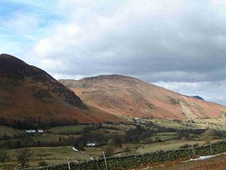
Barrow is small fell in the English Lake District in the county of Cumbria which reaches a height of 455 metres (1,494 feet). It is situated in the quiet and picturesque Newlands Valley just 4 kilometres south-west of the town of Keswick. Although modest in height, Barrow commands a fine all-round view, with the vales of Keswick and Newlands being well seen. The name of the fell originates from the Anglo Saxon language meaning a hill or long ridge.

In archaeology, a phase refers to the logical reduction of contexts recorded during excavation to near contemporary archaeological horizons that represent a distinct "phase" of previous land use. These often but not always will be a representation of a former land surface or occupation level and all associated features that were created into or from this point in time. A simplified description of phase would be that" a phase is a view of a given archaeological site as it would have been at time X".

Single context recording was initially developed by Ed Harris and Patrick Ottaway in 1976, from a suggestion by Lawrence Keene. It was further developed by the Department of Urban Archaeology from where it was then exported, in the mid-1980s by Pete Clarke to the Scottish Urban Archaeological Trust and Nick Pearson to the York Archaeological Trust. It has become a popular system of recording and planning being used in many countries in Europe and in Lebanon, it is especially suited to the complexities of deep, typically urban, archaeology. Each excavated context is given a unique "context number" and is recorded by type on a context sheet and perhaps being drawn on a plan and/or a section. Depending on time constraints and importance contexts may also be photographed, but in this case a grouping of contexts and their associations are the purpose of the photography. Finds from each context are bagged and labelled with their context number and site code for later cross reference work carried out post excavation. The height above sea level of pertinent points on a context, such as the top and bottom of a wall are taken and added to plans sections and context sheets. Heights are recorded with a dumpy level or total station by relation to the site temporary benchmark. Samples of deposits from contexts are sometimes also taken, for later environmental analysis or for scientific dating.

The Bull Ring is a Class II henge that was built in the late Neolithic period near Dove Holes in Derbyshire, England.
Archaeological Illustration is a form of technical illustration that records material derived from an archaeological context graphically.

Towosahgy State Historic Site (23MI2), also known as "Beckwith's Fort," is a large Mississippian earthwork mound site with a Woodland period Baytown culture component located in Mississippi County, Missouri. It is believed to have been inhabited from c. 400-1350. The site is maintained by the Missouri Department of Natural Resources as a state historic site. The name Towosahgy is an Osage word which means "old town." It is not known if members of the historic Osage, who dominated a large area of present-day Missouri at the beginning of encounter with European colonizers, occupied the site. The site includes the Beckwith's Fort Archeological Site, added to the National Register of Historic Places in 1969.
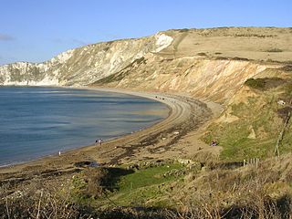
Flower’s Barrow is an Iron Age hillfort, built over 2500 years ago, above Worbarrow Bay in Dorset on the south coast of England.
This page is a glossary of archaeology, the study of the human past from material remains.

